Mohni

Mohni

Vorlage:Infobox Insel/Wartung/Höhe fehlt

Mohni
Leuchtturm auf Mohni
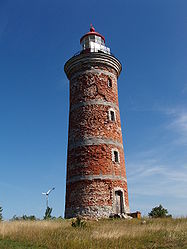
Gewässer Finnischer Meerbusen
Geographische Lage 59° 41′ 2″ N, 25° 47′ 44″ O59.68388888888925.795555555556Koordinaten: 59° 41′ 2″ N, 25° 47′ 44″ O
Mohni (Estland)
Mohni
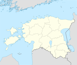
Fläche 0,63 km²

Mohni (deutsch und schwedisch Ekholm) ist eine unbewohnte Insel in der Ostsee vor der Nordküste Estlands im Finnischen Meerbusen. Sie gehört verwaltungsmäßig zur Gemeinde Loksa.

Der Name stammt vermutlich von gotländischen Mönchen, die sich im Mittelalter auf der Insel angesiedelt hatten. Später war die Insel beliebtes Ziel von Fischern und Alkoholschmugglern nach Skandinavien. Anfang des 19. Jahrhunderts wurde ein 27,4 m hoher Leuchtturm errichtet, der 1871 renoviert wurde.

Die Fläche von Mohni beträgt 63 Hektar. Etwa die Hälfte der Insel ist bewaldet. Sie ist Ausflugsziel von Touristen. Vom Kunstmuseum im 4 km entfernten Viinistu aus gibt es einen unregelmäßigen Schiffsverkehr. Mohni ist heute Teil des Nationalparks Lahemaa.

Auf Mohni lebte und arbeitete zeitweise die estnische Dichterin Kristiina Ehin.

Weblinks

 Commons: Mohni – Sammlung von Bildern, Videos und Audiodateien

Wikimedia Foundation.

Игры ⚽ Нужно сделать НИР?

Schlagen Sie auch in anderen Wörterbüchern nach:

  • Mohni — is an island belonging to the country of Estonia. See also List of islands of Estonia …   Wikipedia

  • Mohni — Sp Mòhnis Ap Mohni L s. Baltijos j., Estija …   Pasaulio vietovardžiai. Internetinė duomenų bazė

  • Mohni road — is one of the oldest Roads of Lahore, Pakistan, and is adjacent to Bilal Gunj (a market famous for second hand parts of vehicles) and behind the shrine of Data Gunj Bakhsh. Mohni Road is also known for its lively life but typical badmash culture …   Wikipedia

  • Mohnia mohni — Scientific classification Kingdom: Animalia Phylum: Mollusca Class: Gastropod …   Wikipedia

  • Nawabshah — نوابشاہ   City   Nawab Shah …   Wikipedia

  • Saaremaa — This article is about the island. For the village in Võru County, see Saaremaa, Võru County. Saaremaa …   Wikipedia

  • Hiiumaa — Tahkuna peninsula is the most northern part of Hiiumaa Geography …   Wikipedia

  • Vormsi — Estonia s fourth largest island, Vormsi (German: Worms, Swedish: Ormsö), is located between Hiiumaa and the mainland with a total area of 93 square kilometers. It is part of a rural municipality Vormsi Parish. From mainland, Vormsi is separated… …   Wikipedia

  • Muhu — (German: Mohn/Moon; in Estonian also called Muhumaa), is an island in the Baltic Sea. With an area of 198 km² it is the third largest island belonging to Estonia, after Saaremaa and Hiiumaa. Together with neighbouring smaller islands of… …   Wikipedia

  • Osmussaar — Limestone cliff on the east coast of Osmussaar Geography Location …   Wikipedia

Share the article and excerpts

Direct link
Do a right-click on the link above
and select “Copy Link”