- Middletown (Rhode Island)
-
Middletown 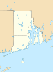

Middletown Lage in Rhode IslandBasisdaten Staat: Vereinigte Staaten Bundesstaat: Rhode Island County: Koordinaten: 41° 33′ N, 71° 17′ W41.545555555556-71.29138888888947Koordinaten: 41° 33′ N, 71° 17′ W Zeitzone: Eastern Standard Time (UTC−5) Einwohner: 17.334 (Stand: 2000) Bevölkerungsdichte: 515,9 Einwohner je km² Fläche: 38,7 km² (ca. 15 mi²)
davon 33,6 km² (ca. 13 mi²) LandHöhe: 47 m Postleitzahlen: 02840, 02842 Vorwahl: +1 401 FIPS: 44-45460 GNIS-ID: 1220063 Middletown ist eine kleine ländliche Stadt im Südosten des US-Bundesstaates Rhode Island auf der gleichnamigen Insel.
Der Name Middletown kommt von der geographischen Lage zwischen Newport und Portsmouth. Seit 1731 ist Middletown kein Teil mehr von Newport. Während des Amerikanischen Unabhängigkeitskriegs wurde das Städtchen 1776 von den Engländern geplündert.
Söhne und Töchter der Stadt
- Wilder Dwight Bancroft (1867-1953), Chemiker
- Mark Cameron (* 1952), Gewichtheber
Weblinks
Kategorien:- Ort in Rhode Island
- Newport County (Rhode Island)

Wikimedia Foundation.