- Marazion
-
50.116666666667-5.45Koordinaten: 50° 7′ N, 5° 27′ W
Marazion 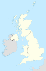

Marazion Lage von Marazion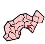 Lage im ehemaligen District Penwith
Basisdaten Status Civil Parish Region South West England Zerem. Grafschaft Cornwall Trad. Grafschaft Cornwall Verwaltungssitz Marazion Einwohner 1466 (2001) Postleitzahl TR17 0xx Telefonvorwahl 01736 Teilorte - Website - Marazion (kornisch: Marghasyow) ist eine Gemeinde und ein Ort im ehemaligen District Penwith der Grafschaft Cornwall in England. Der Ort liegt an der Mount's Bay, 2 km östlich von Penzance an der Great Western Railway. Bei Ebbe verbindet ein Damm die Insel St. Michael’s Mount mit Marazion.
Die Kirche von St Hilary, die 1853 bei einem Brand zerstört wurde, wurde originalgetreu nachgebaut. Mehr Interesse haben Archäologen aber an deren Kirchhof. Die dort beschrifteten Steine stammen teilweise aus dem vierten Jahrhundert, einer davon wurde zu Ehren des Kaisers Konstantin dem Großen hergestellt. Ein weiterer hat eine Beschriftung mit kornischen Zeichen, die jedoch nicht mehr entziffert werden können. Daneben befinden sich noch britische und römische Kreuze.
Weblinks
 Commons: Marazion – Sammlung von Bildern, Videos und Audiodateien
Gwinear-Gwithian | Hayle | Ludgvan | Madron | Marazion | Morvah | Paul | Penzance | Perranuthnoe | Sancreed | Sennen | St Buryan | St Erth | St Hilary | St Ives | St Just in Penwith | St Levan | St. Michael’s Mount | Towednack | Zennor
Wikimedia Foundation.
Schlagen Sie auch in anderen Wörterbüchern nach:
Marazion — For the Royal Navy warship, see HMS Marazion (1919). Coordinates: 50°07′31″N 5°28′33″W / 50.125278°N 5.475833°W / 50.125278; 5.475833 … Wikipedia
Marazion — Original name in latin Marazion Name in other language Marazion, Marghas Yow State code GB Continent/City Europe/London longitude 50.12556 latitude 5.47505 altitude 17 Population 1466 Date 2013 04 27 … Cities with a population over 1000 database
Marazion Marsh — Coordinates: 50°07′31″N 5°28′33″W / 50.1253°N 5.4758°W / 50.1253; 5.4758 … Wikipedia
HMS Marazion — was a Hunt class minesweeper (1916) launched by Fleming Ferguson, Paisley, Yard No 453, on 15 April 1919 and sold in March 1933 in Hong Kong. It acted as a submarine tender and was present at the sinking of HMS Poseidon in 1931.ee also*Marazion,… … Wikipedia
Disused railway stations (Plymouth to Penzance Line) — Plymouth to Penzance Legend … Wikipedia
Diocese of Truro — Location Ecclesiastical province Canterbury Archdeaconries Bodmin, Cornwall Coordinates … Wikipedia
Mount's Bay — from helicopter Mount s Bay This page is on the geographic … Wikipedia
St Michael's Mount — Infobox UK place static static image caption = St Michael s Mount country = England official name= St Michael s Mount cornish name = Carrack Looz en Cooz latitude= 50.1160 longitude= 5.4772 area total sq mi= 0.09 population density= area… … Wikipedia
Penzance — Infobox UK place official name=Penzance country=England region=South West England map type= Cornwall static static image caption= population=20,255 (2001)cite web url=http://www.statistics.gov.uk/downloads/census2001/ks ua ew part1.pdf format=pdf … Wikipedia
Oldest town in Britain — The Oldest town in Britain is a title claimed by a number of settlements in Great Britain. Contents 1 Thatcham 2 Abingdon 3 Colchester 4 Ipswich … Wikipedia
Marazion


18+
© Academic, 2000-2024
- Kontaktieren Sie uns: Unterstützung, Werbung
Wörterbücher Export, schritte mit PHP, Joomla, Drupal, WordPress, MODx.