- Manono
-
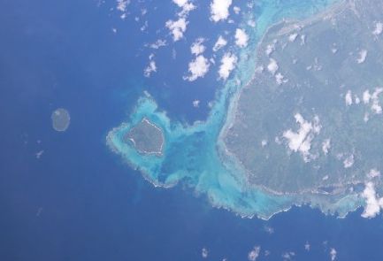
Manono NASA-Bild von Manono, rechts Upolu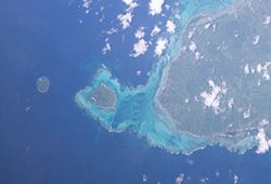
Gewässer Pazifischer Ozean Inselgruppe Samoainseln Geographische Lage 13° 51′ 4″ S, 172° 6′ 36″ W-13.851-172.11Koordinaten: 13° 51′ 4″ S, 172° 6′ 36″ W 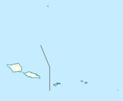

Länge 2,4 km Breite 1,5 km Fläche 2,9 km² Einwohner 889 (2006)
307 Einw./km²Hauptort Lepuiaʻi Faleoʻo, Grashütte auf Manono, 2009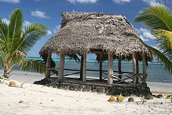
Manono ist eine Insel von Samoa, die zwischen den beiden Hauptinseln des Staates Samoa Savaiʻi und Upolu liegt.
Inhaltsverzeichnis
Geographie
Manono ist 2,4 km lang und maximal 1,5 km breit. Die gesamte Insel wird von einem Korallenriff umschlossen. Die nur 2,9 km² große Insel liegt ca. 3 km von der Westspitze Upolus entfernt und ist durch eine flache Wasserstraße von ihr getrennt. Manono ist sehr flach und hat nur eine leichte Erhebung in ihrer Mitte (den Krater eines erloschenen Vulkans), sie wird deswegen auch Flat Island genannt.
700 m nordwestlich von Manono liegt das kleine unbewohnte Eiland Nuʻulupa, 37 m hoch und mit einem Durchmesser von etwa 100 m.
Administrativ gehört die Insel zum Aiga-i-le-Tai Bezirk.
Bevölkerung
Die Insel hatte 889 Einwohner (2006 Zensus). Die wichtigsten Dörfer (Einwohner) von Manono sind Apai (111), Faleu (354), Lepuiaʻi (223) und Salua (201).[1] Es gibt keine Straßen auf der Insel, lediglich ein Fußweg verbindet die Dörfer miteinander.
Die Bewohner bauen Taro, Yams, Bananen und Kokosnüsse an. Von geringer Bedeutung ist der Tourismus.
Eine Sage erzählt, dass eine alte Frau von Hunden angefallen und getötet wurde, seitdem sind keine Hunde auf der Insel erlaubt.
Die Insel gehört mit ihren beiden Nachbarinseln Apolima und Nuʻulopa zum UNESCO-Welterbe.
Einzelnachweise
- ↑ 2006 Samoa Zensus: Population by region, faipule districts, village, age and sex, 2006. Government of Samoa. Retrieved 4 January, 2009
Weblinks
Inseln der SamoainselnSamoa: Aleipata-Inseln | Apolima | Manono | Savaiʻi | Upolu
Amerikanisch-Samoa: Aunuʻu | Ofu-Olosega | Rose-Atoll | Taʻū | Tutuila
Wikimedia Foundation.
Schlagen Sie auch in anderen Wörterbüchern nach:
Manono — may refer to: Manono Island, Samoa Manono, Democratic Republic of the Congo (Tanganyika Province) Manono, the Māori name given to plants of the Coprosma species Coprosma grandifolia, found in New Zealand. Manono, the Hawaiian name given to… … Wikipedia
Manono — Manōno, Insel bei der Insel Apolima (s.d.) … Kleines Konversations-Lexikon
Manono — Manonọ, eine der Samoainseln, gehört zu Samoa. … Universal-Lexikon
Manono — Cette page d’homonymie répertorie les différents sujets et articles partageant un même nom. Manono, localité et territoire de la République démocratique du Congo Manono, île des Samoa Catégorie : Homonymie … Wikipédia en Français
Manono Island — Manono Satellite image of Manono island with Upolu to the east and tiny Apolima island to the west (NASA photo) Geography … Wikipedia
Manono (Republique democratique du Congo) — Manono (République démocratique du Congo) Pour les articles homonymes, voir Manono. Territoire de Manono … Wikipédia en Français
Manono (République démocratique du Congo) — Pour les articles homonymes, voir Manono. Territoire de Manono … Wikipédia en Français
Manono (république démocratique du congo) — Pour les articles homonymes, voir Manono. Territoire de Manono … Wikipédia en Français
Manono Uta — is a village on the island of Upolu in Samoa. It is situated on the north west coast of the island in the political district of Aiga i le Tai.[1] The population is 1,358 (2006 Census).[2] See also Manono Island References ^ … Wikipedia
manono rūgštis — statusas T sritis chemija apibrėžtis Manozės oksidacijos produktas. formulė HOOC(CHOH)₅H atitikmenys: angl. mannonic acid rus. манноновая кислота … Chemijos terminų aiškinamasis žodynas
Manono


18+
© Academic, 2000-2024
- Kontaktieren Sie uns: Unterstützung, Werbung
Wörterbücher Export, schritte mit PHP, Joomla, Drupal, WordPress, MODx.