- Manitoulin District
-
Manitoulin District 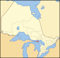
Lage des Manitoulin District in OntarioProvinz Ontario Verwaltungssitz Gore Bay Fläche 4796,0 km² Einwohner (2006) 13.090 Bevölkerungsdichte 2,7 Ew./km² Der Manitoulin District ist ein Verwaltungsbezirk im Zentrum der kanadischen Provinz Ontario. Hauptort ist Gore Bay. Die Einwohnerzahl beträgt 13.090 (2006), die Fläche 4796,0 km², was einer Bevölkerungsdichte von 2,7 Einwohnern je km² entspricht. Der Bezirk umfasst die Insel Manitoulin und weitere Inseln im Huronsee.
Gemeinden
- Assiginack
- Barrie Island
- Billings
- Burpee and Mills
- Central Manitoulin
- Cockburn Island
- Gordon
- Gore Bay
- Northeastern Manitoulin and The Islands
- Tehkummah
Weblinks

Einstufige Gemeinden: Brant | Brantford | Chatham-Kent | Greater Sudbury | Haldimand | Hamilton | Kawartha Lakes | Norfolk | Ottawa | Prince Edward | Toronto
Regionalgemeinden: Durham | Halton | Muskoka | Niagara | Oxford | Peel | Waterloo | York
Countys: Bruce | Dufferin | Elgin | Essex | Frontenac | Grey | Haliburton | Hastings | Huron | Lambton | Lanark | Leeds and Grenville | Lennox and Addington | Middlesex | Northumberland | Perth | Peterborough | Prescott and Russell | Renfrew | Simcoe | Stormont, Dundas and Glengarry | Wellington
Distrikte: Algoma | Cochrane | Kenora | Manitoulin | Nipissing | Parry Sound | Rainy River | Sudbury | Thunder Bay | Timiskaming
Wikimedia Foundation.
Schlagen Sie auch in anderen Wörterbüchern nach:
Manitoulin District — District Gore Bay … Wikipedia
Manitoulin District, Ontario — Manitoulin District is a district in Northeastern Ontario within the Canadian province of Ontario. It was created in 1888 from part of Algoma District. The district seat is Gore Bay.It comprises Manitoulin Island and a number of small islands… … Wikipedia
Manitoulin District municipal elections, 2010 — Elections were held in the organized municipalities in the Manitoulin District of Ontario on October 25, 2010 in conjunction with municipal elections across the province. Contents 1 Assiginack 2 Billings 3 Burpee and Mills … Wikipedia
Unorganized West Manitoulin District — Manitoulin, Unorganized West Part is an unorganized area in Manitoulin District in northeastern Ontario, Canada, encompassing the portion of Manitoulin Island which is not part of an organized municipality.[1] It comprises the geographic… … Wikipedia
List of secondary highways in Manitoulin District — This is a list of secondary highways in Manitoulin District, which serve the isolated and sparsely populated areas in the Manitoulin District of Ontario. Contents 1 Highway 540 2 Highway 540A 3 Highway 540B … Wikipedia
Unorganized Mainland Manitoulin District — Unorganized Mainland Manitoulin is an unorganized area in the Canadian province of Ontario, encompassing the small mainland portion of the Manitoulin District which is not part of the municipality of Killarney.[1] It comprises the geographic… … Wikipedia
Manitoulin Island — Manitoulin Satellite image of Manitoulin Island. Geography Location … Wikipedia
Manitoulin Streams Improvement Association — is a not for profit group that rehabilitates streams, rivers and creeks on the largest freshwater island in the world Manitoulin Island, Ontario, Canada. They partner with the entire community, including farmers, fisherman, and local lake and… … Wikipedia
Manitoulin, Unorganized, Mainland, Ontario — Manitoulin, Unorganized, Mainland is an unorganized area in the Canadian province of Ontario, encompassing the small mainland portion of the Manitoulin District which is not part of the municipality of Killarney. [… … Wikipedia
District de Manitoulin — 45°46′N 82°12′W / 45.767, 82.2 … Wikipédia en Français
Manitoulin District

18+
© Academic, 2000-2024
- Kontaktieren Sie uns: Unterstützung, Werbung
Wörterbücher Export, schritte mit PHP, Joomla, Drupal, WordPress, MODx.