- Macclesfield (Borough)
-
Borough of Macclesfield 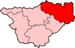
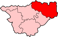
Lage in CheshireStatus Borough Region West Midlands Verw.grafschaft Cheshire Verwaltungssitz Macclesfield Fläche 524,97 km² (95.) Einwohner 151.600 (109.) ONS-Code 13UG Website - Gründung 1974 Auflösung 2009 Macclesfield war ein District mit dem Status eines Borough in der Grafschaft Cheshire in England. Verwaltungssitz war die Stadt Macclesfield, in der rund ein Drittel der Bevölkerung lebte. Weitere bedeutende Orte waren Alderley Edge, Bollington, Knutsford und Wilmslow.
Der Bezirk wurde am 1. April 1974 gebildet und entstand aus der Fusion des Municipal Borough Macclesfield, der Urban Districts Alderley Edge, Bollington, Knutsford und Wlmslow sowie des Rural District Bucklow. Am 1. April 2009 wurde er aufgrund einer Gebiets- und Verwaltungsreform aufgelöst und ging in der neuen Unitary Authority Cheshire East auf.
Chester | Congleton | Crewe and Nantwich | Ellesmere Port and Neston | Macclesfield | Vale Royal
Wikimedia Foundation.
Schlagen Sie auch in anderen Wörterbüchern nach:
Macclesfield (borough) — For the principal settlement of this borough, see Macclesfield. Infobox UK District name = Borough of Macclesfield status = Non metropolitan district, Borough region = North West England admincounty = Cheshire area = Ranked 95th 524.97 km²… … Wikipedia
Macclesfield Forest — is an area of woodland, predominantly conifer plantation, located around 5 km (3 miles) south east of Macclesfield in the civil parish of Macclesfield Forest and Wildboarclough, in Cheshire, England. The existing woodland is the last substantial… … Wikipedia
Macclesfield Forest and Wildboarclough — is a civil parish within the Borough of Macclesfield, Cheshire, England.cite web|last = Macclesfield Borough Council|title=Parish Clerks|publisher = Macclesfield Borough Council url=http://www.macclesfield.gov.uk/standardpage.asp?pageid=10538|acce… … Wikipedia
Macclesfield (disambiguation) — Macclesfield is a market town in Cheshire, England. It may also refer to: * Macclesfield (UK Parliament constituency) mdash; a constituency represented in the British House of Commons * Macclesfield (borough) mdash; a local government district… … Wikipedia
Macclesfield — infobox UK place country = England map type=Cheshire static static image caption=Macclesfield Town Hall official name= Macclesfield latitude= 53.2581 longitude= 2.1274 population = 50,688 shire district= Macclesfield shire county= Cheshire region … Wikipedia
Macclesfield railway station — Infobox UK station name = Macclesfield code = MAC manager = Virgin Trains locale = Macclesfield borough = Macclesfield usage0405 = 0.713 usage0506 = 0.915 usage0607 = 1.086 platforms = 3 start = 1 July 1873Macclesfield railway station is a main… … Wikipedia
Macclesfield Council election, 2007 — Elections to Macclesfield Council were held on 3 May, 2007. One third of the council was up for election and the Conservative Party kept overall control of the council with a majority of 16 seats. Overall turnout was 35.9%.After the election, the … Wikipedia
Macclesfield Council election, 2006 — Elections to Macclesfield Council were held on 4 May, 2006. One third of the council was up for election. In addition there was a by election for the High Legh ward on the same day, where Charles Oulton (Conservative) was elected unopposed. The… … Wikipedia
Macclesfield Rural District — was a rural district of Cheshire, England from 1894 to 1974. All of it is now part of the borough of Macclesfield.Macclesfield as a Municipal Borough and Bollington as an urban district formed an enclave which was surrounded by Macclesfield… … Wikipedia
Macclesfield — Macclesfield … Wikipédia en Français
Macclesfield (Borough)
18+
© Academic, 2000-2024
- Kontaktieren Sie uns: Unterstützung, Werbung
Wörterbücher Export, schritte mit PHP, Joomla, Drupal, WordPress, MODx.