Lower Falls

Lower Falls
Lower Falls

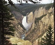
Die Lower Falls sind Wasserfälle des Yellowstone River im US-Bundesstaat Wyoming. Sie befinden sich östlich der Ortschaft Canyon Village, am südlichen Ende des Grand Canyon of the Yellowstone im Yellowstone-Nationalpark. Mit einer Fallhöhe von 94 m sind sie die höchsten Fälle des Parkes und knapp doppelt so hoch wie die Niagarafälle.

Die Lower Falls können von vier Aussichtspunkten aus betrachtet werden: vom Inspiration Point, Grandview Point und Lookout Point östlich der Schlucht und vom Artist Point auf der westlichen Seite.

Der Name tauchte erstmals in einer Karte von 1869 auf. 1889 kursierte ein Plan, wonach ein Lift Besucher direkt zum Fuß der Lower Falls bringen sollte; der Plan wurde nie umgesetzt.

In ihrer Nähe befinden sich zwei weitere Fälle, die Upper Falls im Süden und die Crystal Falls im Westen.

Weblinks

 Commons: Yellowstone Falls – Sammlung von Bildern, Videos und Audiodateien
44.717994-110.496037

Wikimedia Foundation.

Игры ⚽ Нужно решить контрольную?

Schlagen Sie auch in anderen Wörterbüchern nach:

  • Lower Falls — The Lower Falls area is located just to the east of Canyon Village in Yellowstone National Park. A one way loop drive takes you to the brink of the Grand Canyon of the Yellowstone and offers four views, with the last stop at the trail that leads… …   Wikipedia

  • Lower Falls (District Electoral Area) — Lower Falls District Electoral Area Map showing Lower Falls wards within Belfast Population (2008 Estimate) District Belfast Ci …   Wikipedia

  • Newton Lower Falls, Massachusetts — Charles River Newton Lower Falls, Massachusetts is a village of Newton, Massachusetts, on the Charles River. The commercial area extends across the river into Wellesley, Massachusetts, where it is known as Wellesley Lower Falls, where a majority… …   Wikipedia

  • St. Mary's Episcopal Church (Newton Lower Falls, Massachusetts) — Infobox nrhp | name =St. Mary s Episcopal Church and Cemetery (St. Mary s Church and Cemetery) Newton Lower Falls Massachusetts nrhp type = |thumb caption = location= 258 Concord Street Newton Lower Falls, Massachusetts area = built =1814 added …   Wikipedia

  • Newton Lower Falls Historic District — U.S. National Register of Historic Places U.S. Historic district …   Wikipedia

  • Newton Lower Falls Branch — The Newton Lower Falls Branch was a branch of the Boston and Albany Railroad running a distance of approximately one mile from the Riverside Station (although not the current layout for the Green Line but the original station above the Charles… …   Wikipedia

  • West of Fifty Lower Falls (Hamilton, Ontario) — Infobox Waterfall name = West of Fifty Lower Falls image size = caption = West of Fifty Lower Falls location = Hamilton, Ontario latitude = longitude = coordinates = elevation = type = Twin Classic height = convert|5.5|m|ft|abbr=on width =… …   Wikipedia

  • Falls Road (Belfast) — Falls Road also refers to the Rochester, Lockport and Niagara Falls Railroad, the New York Central Railroad s line to Niagara Falls, New York. The Falls Road ( Bóthar na bhFál in Irish, meaning road of the hedgerows ) is the main road through… …   Wikipedia

  • Falls Curfew — Falls Road Curfew Teil von: The Troubles Politische Karte Irlands …   Deutsch Wikipedia

  • Falls Curfew — The Falls Curfew, also known as the Lower Falls Curfew or sometimes as the Rape of the Lower Falls , was a British Army operation on the Falls Road in Belfast, Northern Ireland between 3 July and 5 July 1970. The operation started with an arms… …   Wikipedia

Share the article and excerpts

Direct link
Do a right-click on the link above
and select “Copy Link”