Lofa County

Lofa County
Lofa
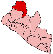
Basisdaten
Hauptstadt Voinjama
Fläche 11.637 km²
Einwohner 247.000 (kein Jahr angegeben)
Bevölkerungsdichte 21,2 Einwohner pro km²
ISO 3166-2 LR-LO

Lofa oder Loffa ist eine Verwaltungsregion (County) Liberias mit etwa 247.000 Einwohnern[1]. Ihre Hauptstadt ist Voinjama.

In der Flagge von Lofa[2] hält ein Arm über einen Fluss hinweg einen Baumstamm, was Einheit über die Wälder und den Fluss Lofa hinweg darstellen soll.

Geographie

Die Region liegt im äußersten Norden Liberias, angrenzend an Guinea und Sierra Leone. 2001 wurde das südwestlich angrenzende Gbarpolu County von Lofa abgespalten. In Lofa liegt der Mount Wuteve.

Benannt ist Lofa nach dem Fluss Lofa.

Geschichte

1999 und in den frühen 2000ern flohen zahlreiche Einwohner wegen des liberianischen Bürgerkrieges aus Lofa. 2004 hatte nach Berichten des Roten Kreuzes die Rückkehr der Flüchtlinge begonnen.

Quellen

  1. statoids.com
  2. Flags of the World

Wikimedia Foundation.

Игры ⚽ Нужен реферат?

Schlagen Sie auch in anderen Wörterbüchern nach:

  • Lofa County — Lofa is the northernmost Liberian county. It is the site of Mount Wuteve, the highest mountain in Liberia.Many people left the area as refugees in 1999 and the early 2000s as it became a main focus of fighting during the Liberian civil war. The… …   Wikipedia

  • Lofa — can refer to: * Lofa County, county in Liberia * Lofa River, river in Liberia * Lofa, a town in Sokoto State, Nigeria * Lofa Tatupu, NFL player …   Wikipedia

  • Lofa Defense Force — The Lofa Defense Force (LDF) was a rebel group that participated in the Liberian Civil War. It was a local group that crossed the northern border from Guinea to attack armed positions, mostly those of the United Liberation Movement of Liberia for …   Wikipedia

  • Lofa — Basisdaten Staat Liberia …   Deutsch Wikipedia

  • Lofa (Fluss) — Lofa Little Cape Mount River Vorlage:Infobox Fluss/KARTE fehlt DatenVorlage:Infobox …   Deutsch Wikipedia

  • District 2, Grand Bassa County — Location of District #2 in Grand Bassa County District #2 is one of six districts located in Grand Bassa County, Liberia …   Wikipedia

  • District 1, Grand Bassa County — Location of District #1 in Grand Bassa County District #1 is one of six districts located in Grand Bassa County, Liberia …   Wikipedia

  • District 3, Grand Bassa County — Location of District #3 in Grand Bassa County District #3 is one of six districts located in Grand Bassa County, Liberia. The city of Buchanan, capital of Grand Bassa County, is located in the district …   Wikipedia

  • District 4, Grand Bassa County — Location of District #4 in Grand Bassa County District #4 is one of six districts located in Grand Bassa County, Liberia …   Wikipedia

  • Gbarpolu County — Created in 2001, Gbarpolu is the youngest of Liberia s 15 counties. It is situated in the northwest of Liberia, occupies an area of approximately 1,263 square miles, and was estimated to have a population of 131,227 inhabitants before the Second… …   Wikipedia

Share the article and excerpts

Direct link
Do a right-click on the link above
and select “Copy Link”