- Little Kiska Island
-
Little Kiska Little Kiska, im Osten von Kiska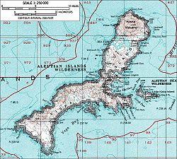
Gewässer Pazifischer Ozean Inselgruppe Aleuten Geographische Lage 51° 57′ 10″ N, 177° 39′ 14″ O51.952777777778177.6538888888992Koordinaten: 51° 57′ 10″ N, 177° 39′ 14″ O 

Höchste Erhebung 92 m Einwohner (unbewohnt) Karte der West-Aleuten, Little Kiska im Osten (8)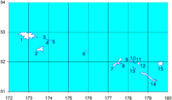
Little Kiska Island ist eine unbewohnte Insel der Rat Islands und gehört zu den Aleuten. Entdeckt wurde sie wie zahlreiche andere Inseln der Aleuten im Jahr 1741 vom russischen Forscher Vitus Bering.
Lage
Die Insel liegt gegenüber Kiska Island bzw. Kiska Harbor. Der höchste Punkt der Insel liegt 92 m über dem Meeresspiegel.
Bedeutung
Im Zweiten Weltkrieg wurde die Insel im Juni 1942 von den Japanern besetzt und im August 1943 zehn Tage vor der Befreiung durch die Alliierten geräumt.
Weblinks
Inseln der Rat IslandsAmchitka | Bird Rock | Davidof | Khvostof | Kiska | Little Kiska | Little Sitkin | Lopy | Pyramid | Rat | Segula | Semisopochnoi | Tanadak
Wikimedia Foundation.
Schlagen Sie auch in anderen Wörterbüchern nach:
Little Kiska Island — is an island off east coast of the island of Kiska in the Aleutian Islands in Alaska. It lies immediately east of Kiska Harbor. [Morison, p. 11.] NotesReferences*Morison, Samuel Eliot. History of United States Naval Operations in World War II,… … Wikipedia
Little Sitkin Island — Little Sitkin Little Sitkin aus dem All gesehen Höhe 1.188 … Deutsch Wikipedia
Kiska Island — Kiska Mount Kiska Gewässer Pazifischer Ozean Inselgruppe … Deutsch Wikipedia
Kiska Harbor — is an inlet on the east coast of the island of Kiska in the Aleutian Islands in Alaska. [ Merriam Webster s Geographical Dictionary, Third Edition , p. 597.] Kiska Harbor is bounded by North Head on the north and by South Head on the south.… … Wikipedia
Kiska — Infobox Islands name = Kiska image caption = A topographical map of Kiska image size = 250px locator map custom = native name = Qisxa native name link = Aleut language nickname = location = coordinates = coord|51|58|2|N|177|29|31|E|display=inline … Wikipedia
Amchitka Island — Die Standorte der drei Kernwaffentests Bild aus Film über den Test Long Shot Amchitka ist eine vulkanische, tektonisch instabile Ins … Deutsch Wikipedia
Tanadak Island (Rat Islands) — Vorlage:Infobox Insel/Wartung/Bild fehltVorlage:Infobox Insel/Wartung/Fläche fehltVorlage:Infobox Insel/Wartung/Höhe fehlt Tanadak Island Gewässer Pazifischer Ozean Inselgruppe Aleuten … Deutsch Wikipedia
Segula Island — Vorlage:Infobox Insel/Wartung/Fläche fehlt Segula Island Satellitenbild von Segula Island Gewässer Pazif … Deutsch Wikipedia
Rat Island (Alaska) — Rat Island NASA Bild von Rat Island Gewässer Pazifik Inselgruppe … Deutsch Wikipedia
Pyramid Island (Alaska) — Vorlage:Infobox Insel/Wartung/Fläche fehlt Pyramid Island NASA Bild von Khvostof und … Deutsch Wikipedia
Little Kiska Island


18+
© Academic, 2000-2024
- Kontaktieren Sie uns: Unterstützung, Werbung
Wörterbücher Export, schritte mit PHP, Joomla, Drupal, WordPress, MODx.