- Antipodes Island
-
Antipodes Island Eine Hütte für Schiffbrüchige im Norden der Insel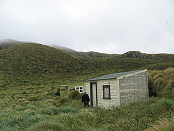
Gewässer Südpazifik Inselgruppe Antipoden-Inseln Geographische Lage 49° 41′ 16″ S, 178° 46′ 27″ O-49.687777777778178.77416666667366Koordinaten: 49° 41′ 16″ S, 178° 46′ 27″ O 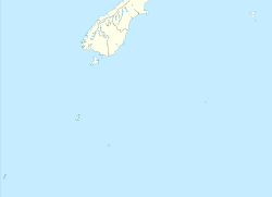

Länge 6,8 km Breite 5,7 km Fläche 20 km² Höchste Erhebung Mount Galloway
366 mEinwohner (unbewohnt) Die South Bay.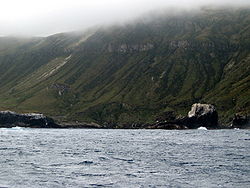
Hier gingen 1893 die Schiffbrüchigen der Spirit of the Dawn an Land und hier verunglückte auch die Totorore.Antipodes Island ist eine unbewohnte Vulkaninsel im südlichen Pazifischen Ozean. Sie ist die größte und Hauptinsel der zu Neuseeland gehörenden Antipoden-Inseln (engl. Antipodes Islands Group).
Geographie
Antipodes Island liegt etwa 770 km südöstlich der Südinsel Neuseelands. Die Insel ist 6,8 km lang, bis zu 5,7 km breit und weist eine Fläche von etwa 20 km² auf. Die Insel besteht aus mehreren Vulkanen vom Typ Schlackenkegel sowie Tuffkegel und erreicht im Mount Galloway eine Höhe von 366 m über dem Meer. Eine weitere nennenswerte Erhebung ist der Mount Waterhouse mit 358 m. Ihre Küste ist von steilen Kliffs aus Basalt geprägt; zahlreiche Klippen sind der Küste vorgelagert. Nördlich von Antipodes Island liegt das deutlich kleinere Bollons Island.
Geschichte
Die Inselgruppe und somit auch die Hauptinsel wurde 1800 von Henry Waterhouse, Kapitän der HMS Reliance, entdeckt. In der Folge sind zahlreiche Schiffe vor und an der Insel verunglückt: Am 4. September 1893 die The Spirit of Dawn, deren elf Überlebende drei Monate auf der Insel ausharren mussten. Unglücklicherweise war ihnen nicht bekannt, das im Nordosten der Insel eine Hütte mit Proviant eingerichtet worden war. Jene Hütte versorgte die Schiffbrüchigen der President Felix Faure im Jahre 1908. Das bislang letzte Unglück ereignete sich an 12. Juni 1999, als die Yacht Totorore sank und deren Segler den Tod fanden.
Weblinks
- Antipodes Island im Global Volcanism Program der Smithsonian Institution (englisch)
- Über die drei Schiffsunglücke (englisch)
- Topografische Karte der Insel
Kategorien:- Unbewohnte Insel
- Insel (Neuseeland)
- Insel (Australien und Ozeanien)
- Insel (Pazifischer Ozean)
- Schlacken- und Aschenkegel
- Antipoden-Inseln


Wikimedia Foundation.