- Liste der Countys in Illinois
-
Der US-amerikanische Bundesstaat Illinois ist in 102 Countys eingeteilt. Die offizielle Abkürzung von Illinois lautet IL, der FIPS-Code ist 17. Der FIPS-Code jedes einzelnen Countys beginnt also stets mit 17, an die die in der Tabelle jeweils genannte dreistellige Zahl angehängt wird.
Die in der Tabelle angegebenen Einwohnerzahlen basieren laut dem United States Census Bureau auf der Volkszählung im Jahr 2010.

County FIPS-Code [1] County Seat Gründung Ursprung Namensherkunft Einwohner
2010[2]Fläche[3] Karte Adams 001 Quincy 1825 Pike County John Quincy Adams
(1767–1848)
sechster Präsident der USA67.103 2.193 km² 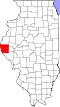
Alexander 003 Cairo 1819 State of Missouri William M. Alexander, Siedler und Abgeordneter der Illinois General Assembly 8.238 605 km² 
Bond 005 Greenville 1817 Crawford County, Edwards County und Madison County Shadrach Bond
(1773–1832)
erster Gouverneur von Illinois17.768 973 km² 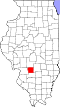
Boone 007 Belvidere 1837 Winnebago County Daniel Boone
(1734-1820)
Wegbereiter der Wilderness Road in Kentucky54.165 720 km² 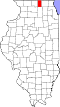
Brown 009 Mount Sterling 1839 Schuyler County Jacob Brown
(1775–1828)
Offizier im amerikanischen Unabhängigkeitskrieg6.937 782 km² 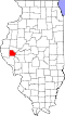
Bureau 011 Princeton 1837 Putnam County Pierre de Bureau
französischer Pelzhändler34.978 2.224 km² 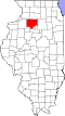
Calhoun 013 Hardin 1825 Pike County John C. Calhoun
(1782–1850),
siebenter Vizepräsident der USA5.089 650 km² 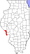
Carroll 015 Mount Carroll 1839 Jo Daviess County Charles Carroll
(1737–1832)
Mitunterzeichner der Unabhängigkeitserklärung15.387 1.137 km² 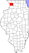
Cass 017 Virginia 1837 Morgan County Lewis Cass
(1782–1866)
zweiter Gouverneur des Michigan-Territoriums, vierzehnter Verteidigungsminister der USA13.642 962 km² 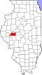
Champaign 019 Urbana 1833 Vermilion County Champaign County (Ohio) 201.081 2.552 km² 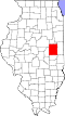
Christian 021 Taylorville 1839 Sangamon County Christian County (Kentucky) 34.800 1.815 km² 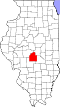
Clark 023 Marshall 1819 Crawford County George Rogers Clark (1752–1818), ranghöchster Offizier im Nordwestterritorium während des amerikanischen Unabhängigkeitskampfes 16.335 1.284 km² 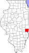
Clay 025 Louisville 1824 Wayne, Lawrence, Fayette, und Crawford County Henry Clay (1777–1852), Unterhändler Kentuckys bei den Verhandlungen, die zum Missouri-Kompromiss führten 13.815 1.201 km² 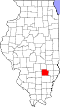
Clinton 027 Carlyle 1824 Washington, Bond, und Fayette County DeWitt Clinton (1769–1828), Gouverneur von New York, verantwortlich für den Bau des Eriekanals 37.762 1.214 km² 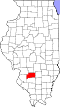
Coles 029 Charleston 1830 Clark und Edgar County Edward Coles (1786–1868), zweiter Gouverneur von Illinois, verantwortlich für das Verbot der Sklaverei in Illinois 53.873 1.301 km² 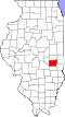
Cook 031 Chicago 1831 Putnam County Daniel Pope Cook (1794–1827), Politiker und erster Attorney General von Illinois 5.194.675 2.421 km² 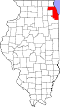
Crawford 033 Robinson 1816 Edwards County William Harris Crawford (1772–1834), neunter Verteidigungsminister der USA, siebenter Finanzminister der USA 19.817 1.135 km² 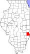
Cumberland 035 Toledo 1843 Coles County umstritten zwischen: Cumberland Road, dem Ort Cumberland (Maryland) oder dem Cumberland River in Kentucky 11.048 886 km² 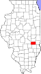
DeKalb 037 Sycamore 1837 Kane County Johann von Kalb (1721–1780), deutscher Offizier, kämpfte in der Kontinentalarmee an der Seite von La Fayette im Amerikanischen Unabhängigkeitskrieg 105.160 1.623 km² 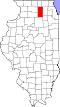
DeWitt 039 Clinton 1839 Macon und McLean County DeWitt Clinton (1769–1828), Gouverneur von New York, verantwortlich für den Bau des Eriekanals 16.561 1.018 km² 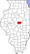
Douglas 041 Tuscola 1859 Coles County Stephen A. Douglas (1813–1861), bekannter Politiker der Demokraten und Widersacher von Abraham Lincoln 19.980 1.067 km² 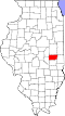
DuPage 043 Wheaton 1839 Cook County DuPage River 816.924 854 km² 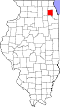
Edgar 045 Paris 1823 Clark County John Edgar 1750–1832, Delegierter von Illinois im Parlament des Nordwestterritoriums 18.576 1.596 km² 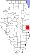
Edwards 047 Albion 1814 Gallatin County und Madison County Ninian Edwards (1775–1833), dritter Gouverneur von Illinois und einziger Gouverneur des Illinois-Territoriums 6.721 569 km² 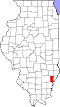
Effingham 049 Effingham 1831 Fayette und Crawford County Earl of Effingham, britischer Offizier, schied aus der Armee aus, um sich den amerikanischen Kolonien anzuschließen 34.242 1.225 km² 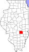
Fayette 051 Vandalia 1821 Bond, Wayne, Clark, Jefferson, und Crawford County Marie-Joseph Motier, Marquis de La Fayette (1757–1834), französischer Offizier im Amerikanischen Unabhängigkeitskrieg und der Französischen Revolution 22.140 1.834 km² 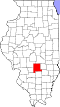
Ford 053 Paxton 1859 Kankakee County Thomas Ford (1800–1850), achter Gouverneur von Illinois 14.081 1.244 km² 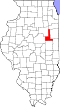
Franklin 055 Benton 1818 White County und Gallatin County Benjamin Franklin (1706–1790), Verleger, Schriftsteller, Staatsmann, Naturwissenschaftler und Erfinder, einer der Gründerväter der USA 39.561 1.055 km² 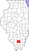
Fulton 057 Lewistown 1823 Pike County Robert Fulton (1765–1815), Ingenieur, entwickelte eines der ersten brauchbaren Dampfschiffe 37.069 2.216 km² 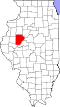
Gallatin 059 Shawneetown 1812 Randolph County Albert Gallatin (1761–1849), vierter und mit 13 Jahren Amtszeit am längsten amtierender Finanzminister der USA 5.589 829 km² 
Greene 061 Carrollton 1821 Madison County Nathanael Greene (1742–1786), General der Kontinentalarmee im Amerikanischen Unabhängigkeitskrieg 13.886 1.390 km² 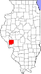
Grundy 063 Morris 1841 LaSalle County Felix Grundy (1777–1840), dreizehnter United States Attorney General 50.063 1.075 km² 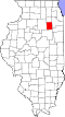
Hamilton 065 McLeansboro 1821 White County Alexander Hamilton (1755–1804), erster Finanzminister der USA 8.457 1.114 km² 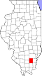
Hancock 067 Carthage 1825 Adams County John Hancock (1737–1793), erster Gouverneur von Massachusetts, Präsident des Kontinentalkongresses, Oberbefehlshaber der Kontinentalarmee 19.104 2.034 km² 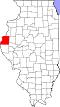
Hardin 069 Elizabethtown 1839 Pope County Hardin County (Kentucky) 4.320 457 km² 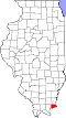
Henderson 071 Oquawka 1841 Warren County Henderson County (Kentucky) 7.331 970 km² 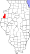
Henry 073 Cambridge 1825 Adams County Patrick Henry 50.486 2.107 km² 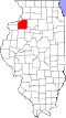
Iroquois 075 Watseka 1833 Vermilion County Indianerstamm der Irokesen 29.718 2.858km² 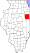
Jackson 077 Murphysboro 1816 Randolph County und Johnson County Andrew Jackson 60.218 1.506 km² 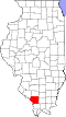
Jasper 079 Newton 1831 Clay und Crawford County William Jasper 9.698 1.266 km² 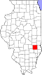
Jefferson 081 Mount Vernon 1819 Edwards und White County Thomas Jefferson 38.827 1.462 km² 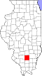
Jersey 083 Jerseyville 1839 Greene County Der Bundesstaat New Jersey, aus dem viele Siedler des Countys stammten 22.985 945 km² 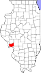
Jo Daviess 085 Galena 1827 Henry, Mercer, und Putnam County Joseph Hamilton Daviess 22.678 1.539 km² 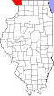
Johnson 087 Vienna 1812 Randolph County Richard Mentor Johnson 12.582 882 km² 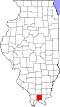
Kane 089 Geneva 1836 Cook County Elias Kane 515.269 1.332 km² 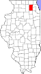
Kankakee 091 Kankakee 1853 Iroquois und Will County Kankakee River 113.449 1.732 km² 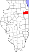
Kendall 093 Yorkville 1841 LaSalle und Kane County Amos Kendall 114.736 821 km² 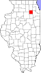
Knox 095 Galesburg 1825 Fulton County General Henry Knox 52.919 1.834 km² 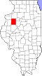
LaSalle County 099 Ottawa 1831 Putnam County Robert Cavelier de La Salle 113.924 2.905 km² 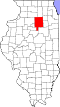
Lake 097 Waukegan 1839 McHenry County Seen auf dem Gebiet des County 703.462 1.146 km² 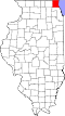
Lawrence 101 Lawrenceville 1821 Crawford und Edwards County James Lawrence 16.833 952 km² 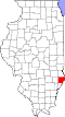
Lee 103 Dixon 1839 Ogle County Henry Lee 36.031 1.857 km² 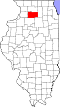
Livingston 105 Pontiac 1837 LaSalle und McLean County Edward Livingston 38.950 2.672 km² 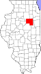
Logan 107 Lincoln 1839 Sangamon County John A. Logan 30.305 1.582 km² 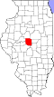
Macon 115 Decatur 1829 Shelby County Nathaniel Macon 110.768 1.486 km² 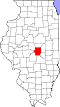
Macoupin 117 Carlinville 1829 Greene County das indianische Wort Macaupiana, was soviel bedeutet wie weiße Kartoffel 47.765 2.211 km² 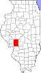
Madison 119 Edwardsville 1812 St. Clair County und Randolph County James Madison (1751–1836), vierter Präsident der USA 269.282 1.856 km² 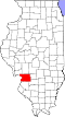
Marion 121 Salem 1823 Fayette und Jefferson County Francis Marion 39.437 1.465 km² 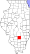
Marshall 123 Lacon 1839 Putnam County John Marshall (1755–1835), Vorsitzender Richter am Obersten Gericht der USA, vierter Außenminister der USA 12.640 988 km² 
Mason 125 Havana 1841 Tazewell und Menard County George Mason (1725–1792), Politiker aus Virginia 14.666 1.380 km² 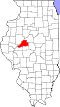
Massac 127 Metropolis 1843 Pope und Johnson County Fort Massac 16.429 612 km² 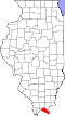
McDonough 109 Macomb 1826 Schuyler County Thomas Macdonough 32.612 1.509 km² 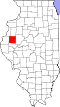
McHenry 111 Woodstock 1836 Cook County General William McHenry 398.760 1.545 km² 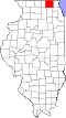
McLean 113 Bloomington 1830 Tazewell County John McLean 169.572 3.030 km² 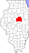
Menard 129 Petersburg 1839 Sangamon County Pierre Menard 12.705 804 km² 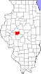
Mercer 131 Aledo 1825 Schuyler County Hugh Mercer 16.434 1.436 km² 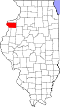
Monroe 133 Waterloo 1816 Randolph County und St. Clair County James Monroe (1758–1831), fünfter Präsident der USA 32.957 994 km² 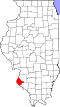
Montgomery 135 Hillsboro 1821 Bond und Madison County Richard Montgomery (1736–1775), General im Amerikanischen Unabhängigkeitskrieg 30.104 1.802 km² 
Morgan 137 Jacksonville 1823 Sangamon County Daniel Morgan 25.547 1.456 km² 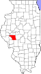
Moultrie 139 Sullivan 1843 Shelby und Macon County William Moultrie (1730–1805), Brigadegeneral im Amerikanischen Unabhängigkeitskrieg, Gouverneur von South Carolina 14.846 859 km² 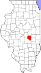
Ogle 141 Oregon 1836 Jo Daviess County Joseph Ogle 53.497 1.943 km² 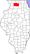
Peoria 143 Peoria 1825 Fulton County der Indianerstamm der Peoria 186.494 1.586 km² 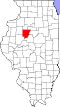
Perry 145 Pinckneyville 1827 Randolph und Jackson County Oliver Hazard Perry 22.350 1.129 km² 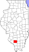
Piatt 147 Monticello 1841 DeWitt und Macon County John Piatt 16.729 1.126 km² 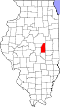
Pike 149 Pittsfield 1821 Madison, Bond, und Clark County Zebulon Pike 16.430 2.126 km² 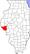
Pope 151 Golconda 1816 Gallatin und Johnson County Nathaniel Pope 4.470 949 km² 
Pulaski 153 Mound City 1843 Alexander und Johnson County Kazimierz Pułaski 6.161 514 km² 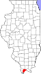
Putnam 155 Hennepin 1825 Peoria County Israel Putnam (1718–1790), General im Amerikanischen Unabhängigkeitskrieg 6.006 409 km² 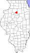
Randolph 157 Chester 1795 St. Clair County Edmund Randolph (1753–1813) Gouverneur von Virginia, Außenminister und United States Attorney General 33.476 1.481 km² 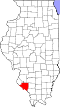
Richland 159 Olney 1841 Clay und Lawrence County Richland County (Ohio) 16.233 922 km² 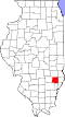
Rock Island 161 Rock Island 1831 Jo Daviess County Rock Island 147.546 1.092 km² 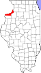
St. Clair 163 Belleville 1790 eines von zwei ursprünglichen Counties Arthur St. Clair 270.056 1.699 km² 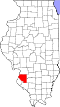
Saline 165 Harrisburg 1847 Gallatin County Salzvorkommen im County 24.913 981 km² 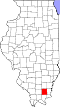
Sangamon 167 Springfield 1821 Madison und Bond County Sangamon River 197.465 2.223 km² 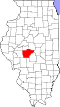
Schuyler 169 Rushville 1825 Pike und Fulton County Philip Schuyler 1.544 1.120 km² 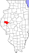
Scott 171 Winchester 1839 Morgan Count Familie Scott 5.355 642 km² 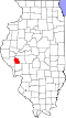
Shelby 173 Shelbyville 1827 Fayette County Isaac Shelby 22.363 1.942 km² 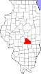
Stark 175 Toulon 1839 Knox und Putnam County John Stark 5.994 737 km² 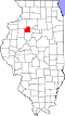
Stephenson 177 Freeport 1837 Jo Daviess und Winnebago County Benjamin Stephenson 47.711 1.444 km² 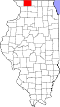
Tazewell 179 Pekin 1827 Sangamon County Littleton Waller Tazewell 135.394 1.661 km² 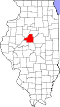
Union 181 Jonesboro 1818 Johnson County Union (Vereinigte Staaten) 17.808 1.065 km² 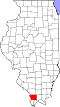
Vermilion 183 Danville 1826 Clark und Edgar County Vermilion River 81.625 2.302 km² 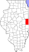
Wabash 185 Mount Carmel 1824 Edwards County Wabash River 11.847 522 km² 
Warren 187 Monmouth 1825 Schuyler County Joseph Warren 17.707 1.389 km² 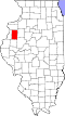
Washington 189 Nashville 1818 St. Clair County George Washington 14.716 1.440 km² 
Wayne 191 Fairfield 1819 Edwards County General Anthony Wayne 16.760 1.828 km² 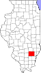
White 193 Carmi 1815 Gallatin County Isaac White 14.665 1.267 km² 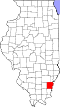
Whiteside 195 Morrison 1836 Jo Daviess und Henry County Samuel Whiteside 58.498 1.753 km² 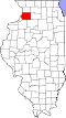
Will 197 Joliet 1836 Cook und Iroquois County Conrad Will 677.560 2.143 km² 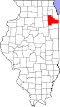
Williamson 199 Marion 1839 Franklin County Hugh Williamson 66.357 184 km² 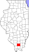
Winnebago 201 Rockford 1836 Jo Daviess County Winnebago (Volk) 295.266 1.315 km² 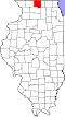
Woodford 203 Eureka 1841 Tazewell und McLean County William Woodford 38.664 1.352 km² 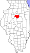
Einzelnachweise
- ↑ U.S. Census Bureau - State & County QuickFacts
- ↑ U.S. Census 2010
- ↑ U.S. Census Bureau - State & County QuickFacts Angaben in Quadratmeilen - Umrechnung in Quadratkilometer
Alabama | Alaska | Arizona | Arkansas | Colorado | Connecticut | Delaware | Florida | Georgia | Hawaii | Idaho | Illinois | Indiana | Iowa | Kalifornien | Kansas | Kentucky | Louisiana | Maine | Maryland | Massachusetts | Michigan | Minnesota | Mississippi | Missouri | Montana | Nebraska | Nevada | New Hampshire | New Jersey | New Mexico | New York | North Carolina | North Dakota | Ohio | Oklahoma | Oregon | Pennsylvania | Rhode Island | South Carolina | South Dakota | Tennessee | Texas | Utah | Vermont | Virginia | Washington | West Virginia | Wisconsin | Wyoming
Wikimedia Foundation.
Schlagen Sie auch in anderen Wörterbüchern nach:
Liste der Städte in Illinois — Die folgende Liste zeigt alle Kommunen und Siedlungen in Illinois. Sie enthält sowohl Citys, Towns und Villages als auch Census designated places (CDP). Die obere Tabelle enthält die Siedlungen, die bei der Volkszählung im Jahr 2010[1] mehr als… … Deutsch Wikipedia
Liste der Countys auf Hawaii — Counties Hawaiis Der US Bundesstaat Hawaii ist in 5 Countys unterteilt: Lage County Fläche Einwohner 1. Juli 2005 Verwaltungs sitz Einwohner 1. April 2000 Bereich … Deutsch Wikipedia
Liste der Countys in Lousiana — Parishes in Louisiana Der US Bundesstaat Louisiana in den Vereinigten Staaten ist in 64 Parishes unterteilt. Ihr Status entspricht dem der Countys in den anderen Bundesstaaten. Acadia … Deutsch Wikipedia
Liste der Countys in Iowa — Der US amerikanische Bundesstaat Iowa ist in 99 Countys eingeteilt. Die offizielle Abkürzung von Iowa ist IA, der FIPS Code ist 19. Der FIPS Code jedes einzelnen Countys beginnt also stets mit 19, an die die in der Tabelle für jedes County… … Deutsch Wikipedia
Liste der Countys in Nevada — Der US Bundesstaat Nevada ist in 17 Countys unterteilt. Die Hauptstadt Carson City ist eine unabhängige Stadt, zählt jedoch nach dem US Census Bureau als County. County Einwohner (1. Juli 2006) Verwaltungssitz Einwohner (1. Juli 2005) Carson City … Deutsch Wikipedia
Liste der Countys in Montana — LN FH LK SA MN MS … Deutsch Wikipedia
Liste der Countys in Kentucky — Boone Ken ton Camp bell Pend leton Bracken Robertson … Deutsch Wikipedia
Liste der Countys in Michigan — Keweenaw Houghton Ontonagon Gogebic Iron Baraga … Deutsch Wikipedia
Liste der Countys in Maryland — Garrett Allegany Washington Frederick Carroll Baltimore … Deutsch Wikipedia
Liste der Counties in North Carolina — Der US Bundesstaat North Carolina ist in 100 Countys unterteilt: Alamance County Alexander County Alleghany County Anson County Ashe County Avery County Beaufort County Bertie County … Deutsch Wikipedia
Liste der Countys in Illinois


18+
© Academic, 2000-2024
- Kontaktieren Sie uns: Unterstützung, Werbung
Wörterbücher Export, schritte mit PHP, Joomla, Drupal, WordPress, MODx.