Lincoln Highway

Lincoln Highway
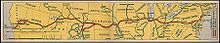
Karte des Lincoln Highways

Der Lincoln Highway, erdacht 1913 von Carl G. Fisher, war die erste Straße in den USA, die Ost- und Westküste verband. Er verlief vom Times Square, New York bis zum Lincoln Park, San Francisco und verband dabei ursprünglich 13 US-Bundesstaaten: New York, New Jersey, Pennsylvania, Ohio, Indiana, Illinois, Iowa, Nebraska, Colorado, Wyoming, Utah, Nevada und Kalifornien. Seine Länge betrug über 3389 Meilen (5454 Kilometer). 1928 wurde die Strecke so umgelegt, dass der Lincoln Highway nun auch die nördlichste Spitze West Virginias berührte. Heute führt der Highway daher durch 14 US-Bundesstaaten.

Literatur

  • Michael Wallis, Michael S. Williamson: The Lincoln Highway: Coast to Coast from Times Square to the Golden Gate. W. W. Norton, New York 2007, ISBN 0-39-305938-3

Siehe auch

Weblinks

 Commons: Lincoln Highway – Sammlung von Bildern, Videos und Audiodateien

Wikimedia Foundation.

Игры ⚽ Поможем написать реферат

Schlagen Sie auch in anderen Wörterbüchern nach:

  • Lincoln Highway — Lincoln Highway …   Wikipédia en Français

  • Lincoln Highway — For the Australian highway, see Lincoln Highway (Australia). Lincoln Highway …   Wikipedia

  • Lincoln Highway Motel — (Matteson,США) Категория отеля: 1 звездочный отель Адрес: 5200 West Lincoln Highway, Mat …   Каталог отелей

  • Lincoln Highway Bridge — bezeichnet mehrere gleichnamige, im NRHP gelistete, Objekte: Lincoln Highway Bridge (Iowa), ID Nr. 78001263 Lincoln Highway Bridge (Utah), ID Nr. 75001825 Diese Seite ist eine Begriffsklärung zur Unterscheidung mehrerer mit demse …   Deutsch Wikipedia

  • Lincoln Highway (Omaha) — Infobox nrhp name = Lincoln Highway (Omaha) caption = Official Lincoln Highway marker. location= Omaha, NE area = built = 1913 architecture= added = 2003 governing body = City of Omaha refnum=03000104 [… …   Wikipedia

  • Lincoln Highway (Australien) — Blick auf Whyalla am Lincoln Highway Der Lincoln Highway ist eine Fernverkehrsstraße in South Australia, Australien. Er verläuft über eine Länge von 330 Kilometern entlang der östlichen Küstenlinie der Eyre Halbinsel und verbindet die Städte Port …   Deutsch Wikipedia

  • Lincoln Highway (Australia) — Infobox Australian Road road name = Lincoln Highway route route route photo = caption = Formerly length = 327 direction = Northeast Southwest start = finish = est = through = Whyalla, Cowell, Arno Bay, Tumby Bay route = exits = : There is also a… …   Wikipedia

  • Route of the Lincoln Highway — The Lincoln Highway followed the following route:New YorkThe very short Lincoln Highway section in New York went west from Times Square on 42nd Street to the Weehawken Ferry. It was realigned down Broadway from which it turned right and passed… …   Wikipedia

  • 211th Street (Lincoln Highway) (Metra) — Infobox Station name=211th Street (Lincoln Highway) type=Metra regional rail image size= image caption= address=211th Street between Olympian Way Olympian Circle Matteson, IL coordinates= line=Rail color box|system=Metra|line=Metra Electric other …   Wikipedia

  • Lincoln Park (San Francisco) — Lincoln Park in San Francisco, California was dedicated to President Abraham Lincoln in 1909 and includes about convert|100|acre|km2|1 of the northwestern corner of the San Francisco Peninsula. It is part of the Golden Gate National Recreation… …   Wikipedia

Share the article and excerpts

Direct link
Do a right-click on the link above
and select “Copy Link”