Leeton Shire

Leeton Shire
Shire of Leeton
Australia-Map-NSW-LGA-Leeton.png
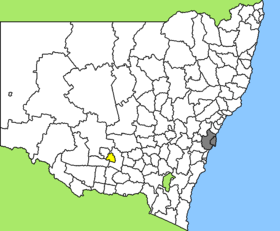
Lage des Leeton Shire in New South Wales
Gliederung
Staat: Australien Australien
Bundesstaat: Flag of New South Wales.svg New South Wales
Verwaltungssitz: Leeton
Daten und Zahlen
Fläche: 1.167 km²
Einwohner: 11.111 (2006) [1]
Bevölkerungsdichte: 9,5 Einwohner je km²
Wards: 3
-34.55146.4

Leeton Shire ist ein lokales Verwaltungsgebiet (LGA) im australischen Bundesstaat New South Wales. Das Gebiet ist 1.167 km² groß und hat etwa 11.700 Einwohner.

Leeton liegt im Süden des Staates am Murrumbidgee River etwa 370 km westlich der australischen Hauptstadt Canberra und 580 km westlich der Metropole Sydney. Das Gebiet umfasst 36 Ortsteile und Ortschaften, darunter Amesbury, Corbie Hill, Fivebough, Gogeldrie, Gralee, Leeton, Leeton North, Merungle Hill, Murrami, Parkview, Stanbridge, Stoney Point, Wamoon, Wattle Hill, Willimbong, Yanco und ein Teil von Whitton. Der Sitz des Shire Councils befindet sich in Leeton im Osten der LGA, wo etwa 6.800 Einwohner leben.

Verwaltung

Der Leeton Shire Council hat neun Mitglieder, die von den Bewohnern der drei Wards gewählt werden (je drei Councillor aus A, B und C Ward). Diese drei Bezirke sind unabhängig von den Ortschaften festgelegt. Aus dem Kreis der Councillor rekrutiert sich auch der Mayor (Bürgermeister) des Councils.

Weblinks

Einzelnachweise

  1. Australian Bureau of Statistics (25. Oktober 2007): Leeton (A) (Local Government Area) (Englisch). 2006 Census QuickStats. Abgerufen am 6. April 2010.

Wikimedia Foundation.

Игры ⚽ Нужна курсовая?

Schlagen Sie auch in anderen Wörterbüchern nach:

  • Leeton Shire Council — Infobox Australian Place | type = lga name = Leeton Shire caption = Location in NSW state=New South Wales region=Riverina area = 1167.12 area footnotes = [cite web|title = Leeton Regional Profile | url =… …   Wikipedia

  • Leeton (New South Wales) — Leeton Pine Avenue, Hauptgeschäftsstraße Staat …   Deutsch Wikipedia

  • Leeton, New South Wales — Infobox Australian Place | type = town name = Leeton state = nsw caption = Location of Leeton lga = Leeton Shire Council postcode = est = pop = 6,828 elevation= maxtemp = 23.0 mintemp = 10.3 rainfall = 432.0 county = Cooper stategov =… …   Wikipedia

  • Leeton (Australie) — 34° 33′ 12″ S 146° 24′ 00″ E / 34.5532, 146.4 …   Wikipédia en Français

  • Leeton High School — is a secondary school in the town of Leeton in South Western New South Wales, Australia. The school is one of three secondary schools in the Local Government Area of Leeton and it has a reputation of excellence in sport, academic and cultural.… …   Wikipedia

  • Leeton — /ˈlitn/ (say leetn) noun a town and shire in southern NSW, south east of Griffith; headquarters of the Murrumbidgee Irrigation Area and of the Rice Marketing Board for NSW. {named after Charles Alfred Lee, 1842–1926, NSW minister for public works …  

  • North Leeton, New South Wales — North Leeton is a suburb located in northern Leeton, New South Wales in Leeton Shire. It is the most rapidly growing area of Leeton with many housing estates such as Karri Estate and Nobel Park Estate being constructed to meet housing demands.… …   Wikipedia

  • Wakool Shire — Shire of Wakool New South Wales Location in New South Wales Population: 4,427(2009) …   Wikipedia

  • Narrandera Shire — New South Wales Location in New South Wales Population: 6 …   Wikipedia

  • Murrumbidgee Shire — New South Wales Murrumbidgee Shire office and chambers Populat …   Wikipedia

Share the article and excerpts

Direct link
Do a right-click on the link above
and select “Copy Link”