Lake Edward

Lake Edward
Eduardsee
Eduardsee (links) und Georgesee (rechts)
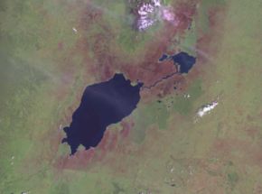
Geographische Lage: Demokratische Republik Kongo, Uganda (Ostafrika)
Zuflüsse: Rutshuru, Rwindi, Nyamugasani, Ishasha
Abflüsse: Semliki
Daten
Koordinaten 0° 21′ S, 29° 35′ O-0.3529.583333333333920Koordinaten: 0° 21′ S, 29° 35′ O
Eduardsee (Uganda)
DEC
Eduardsee
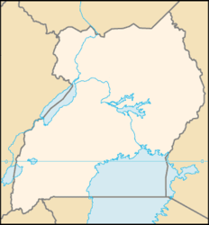
Höhe über Meeresspiegel 920 m
Fläche 2.325 km²dep1
Seelänge 77 km
Seebreite 40 km
Volumen 39 km³dep1
Maximale Tiefe 112 mdep1
Mittlere Tiefe 17 mdep1

Der Eduardsee (Edwardsee), der auch Rutanzigesee genannt wird, liegt in Ost-Afrika größtenteils in der Demokratischen Republik Kongo, der Nordosteil liegt in Uganda.

Östlich der großen Zentralafrikanischen Schwelle und westlich des Uganda-Hochlands liegt der See, der Teil des Ostafrikanischen Grabenbruchs ist, direkt südlich des Ruwenzori-Gebirges. Während der Eduardsee von vielen kleinen Bächen und Flüssen gespeist wird (dazu gehören der Rutshuru und Rwindi), ist sein einziger Abfluss der Semliki, der den See am Nordwestufer verlässt, um weiter nördlich in den Albertsee zu münden. Im Osten ist er durch den Fluss Kazinga mit dem Georgesee verbunden. Er hat eine maximale Länge von 65 km und eine maximale Breite von 38 km.


Henry Morton Stanley entdeckte den fischreichen See 1876 für die westliche Welt, besuchte ihn 1889 und nannte ihn nach Albert Edward, dem damaligen Prince of Wales (später König Edward VII.).

Als Idi Amin in Uganda regierte nannte man den See in diesem Land Idi-Amin-See oder Idi-Amin-Dada-See.

Die Verwaltung übernimmt im Kongo der Virunga-Nationalpark und in Uganda der Queen Elizabeth National Park.

Weblinks


Wikimedia Foundation.

Игры ⚽ Поможем сделать НИР

Schlagen Sie auch in anderen Wörterbüchern nach:

  • Lake Edward — Infobox lake lake name = Lake Edward image lake = Wfm lake edward lake george.jpg caption lake = NASA Landsat photo of Lake Edward and Lake George showing the Kazinga Channel between them image bathymetry = caption bathymetry = coords =… …   Wikipedia

  • Lake Edward — noun a lake in the Great Rift Valley between Congo and Uganda • Instance Hypernyms: ↑lake • Part Holonyms: ↑Congo, ↑Democratic Republic of the Congo, ↑Zaire, ↑Belgian Congo, ↑Uganda, ↑Republic of Uganda …   Useful english dictionary

  • Municipio de Lake Edward (condado de Crow Wing, Minnesota) — Municipio de Lake Edward Municipio de los Estados Unidos …   Wikipedia Español

  • Edward, Lake — Lake, eastern Africa. One of the great lakes of the western Great Rift Valley, it lies on the border of Democratic Republic of the Congo and Uganda and is 48 mi (77 km) long and 26 mi (42 km) wide. On the northeast it is connected to the smaller… …   Universalium

  • Lake George (Uganda) — Infobox lake lake name = Lake George image lake = Wfm lake edward lake george.jpg caption lake = NASA Landsat photo of Lake Edward (larger) and Lake George (smaller). image bathymetry = caption bathymetry = location = coords =… …   Wikipedia

  • lake — lake1 /layk/, n. 1. a body of fresh or salt water of considerable size, surrounded by land. 2. any similar body or pool of other liquid, as oil. 3. (go) jump in the lake, (used as an exclamation of dismissal or impatience.) [bef. 1000; ME lak(e) …   Universalium

  • Lake — /layk/, n. Simon, 1866 1945, U.S. engineer and naval architect. * * * I Relatively large body of slow moving or standing water that occupies an inland basin. Lakes are most abundant in high northern latitudes and in mountain regions, particularly …   Universalium

  • Lake Victoria — Infobox lake lake name = Lake Victoria image lake = Topography of Lake Victoria.png image bathymetry = caption bathymetry = coords = coord|1|S|33|E|type:waterbody|display=inline,title outflow = White Nile River catchment = 184,000 km² 238,900 km² …   Wikipedia

  • Lake Rutanzige — Eduardsee Eduardsee (links) und Georgesee (rechts) Geographische Lage: Demokratische R …   Deutsch Wikipedia

  • Lake Albert (Africa) — Infobox lake lake name = Lake Albert image lake = Lake Albert (Uganda) (NASA).jpg caption lake = 2002 NASA MODIS satellite picture. The dotted grey line is the border between Congo (DRC) (left) and Uganda (right). image bathymetry = caption… …   Wikipedia

Share the article and excerpts

Direct link
Do a right-click on the link above
and select “Copy Link”