Kyogle Council

Kyogle Council
Kyogle Council
Australia-Map-NSW-LGA-Kyogle.png
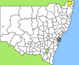
Lage des Kyogle Council in New South Wales
Gliederung
Staat: Australien Australien
Bundesstaat: Flag of New South Wales.svg New South Wales
Verwaltungssitz: Kyogle
Daten und Zahlen
Fläche: 3.589 km²
Einwohner: 9.256 (2006) [1]
Bevölkerungsdichte: 2,6 Einwohner je km²
-28.65152.85

Kyogle Council ist ein lokales Verwaltungsgebiet (LGA) im australischen Bundesstaat New South Wales. Das Gebiet ist 3.589 km² groß und hat etwa 9.300 Einwohner.

Kyogle liegt im äußersten Nordosten des Staates in der Region Richmond-Tweed etwa 750 km nördlich der Metropole Sydney und 130 km südlich von Brisbane. Das Gebiet umfasst 128 Ortsteile und Ortschaften, darunter Afterlee, Bonalbo, Old Bonalbo, Bottle Creek, Cawongla, Cedar Point, Dyraaba Creek, Eden Creek, Ettrick, Green Pigeon, Grevillia, Old Grevillia, Kyogle, Mallanganee, Mount Lion, Mummulgum, Rappville, Tabulam, Tooloom, Toonumbar, Wadeville, Wiangaree, Woolners Arm und Teile von Paddys Flat und Woodenbong. Der Verwaltungssitz des Councils befindet sich in der Stadt Kyogle im Osten der LGA, wo etwa 2.700 Einwohner leben.

Verwaltung

Der Council von Kyogle hat neun Mitglieder, die von den Bewohnern der drei Wards gewählt werden (je drei aus A, B und C Ward). Diese drei Bezirke sind unabhängig von den Ortschaften festgelegt. Aus dem Kreis der Councillor rekrutiert sich auch der Mayor (Bürgermeister) des Councils.

Weblinks

Einzelnachweise

  1. Australian Bureau of Statistics (25. Oktober 2007): Kyogle (A) (Local Government Area) (Englisch). 2006 Census QuickStats. Abgerufen am 6. April 2010.

Wikimedia Foundation.

Игры ⚽ Поможем сделать НИР

Schlagen Sie auch in anderen Wörterbüchern nach:

  • Kyogle Council — Infobox Australian Place | type = lga name=Kyogle Council caption = Location in New South Wales state=nsw region=Northern Rivers area=3589 area footnotes = cite web title=Kyogle Council publisher = Department of Local Government url =… …   Wikipedia

  • Kyogle, New South Wales — Kyogle is a town of approximately 4000 persons in the Northern Rivers region of northern New South Wales, Australia, in Kyogle Council. It was founded in the 1830 s as a lumber camp, and is located 758 km north of Sydney, 32 km north of Casino on …   Wikipedia

  • Marrickville Council — New South Wales Population: 78,271(2009) …   Wikipedia

  • Burwood Council — New South Wales Population: 33,803(2009) …   Wikipedia

  • Manly Council — New South Wales Population: 40 …   Wikipedia

  • North Sydney Council — New South Wales Population: 63,914(2009) …   Wikipedia

  • Clarence Valley Council — Clarence Valley New South Wales Location in New South Wales Population …   Wikipedia

  • Deniliquin Council — New South Wales Population: 7,693(2009) …   Wikipedia

  • Tweed Shire Council — Infobox Australian Place | type = lga name=Tweed Shire caption = Location in New South Wales state=nsw region=Northern Rivers area=1309 area footnotes= cite web title=Tweed Shire Council publisher = Department of Local Government url = http://www …   Wikipedia

  • Richmond Valley Council — Infobox Australian Place | type = lga name = Richmond Valley state = nsw caption = Location in New South Wales pop = formatnum:21313 pop footnotes = [census 2006 AUS|id=LGA16610|name=Richmond Valley (A) (Local Government… …   Wikipedia

Share the article and excerpts

Direct link
Do a right-click on the link above
and select “Copy Link”