- Kinlochbervie
-
Kinlochbervie Koordinaten 58° 28′ N, 5° 3′ W58.459166666667-5.0475Koordinaten: 58° 28′ N, 5° 3′ W 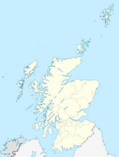

Kinlochbervie Verwaltung Post town LAIRG Postleitzahlenabschnitt IV27 Vorwahl 01971 Landesteil Scotland Unitary authority Highland Britisches Parlament Caithness, Sutherland and Easter Ross Schottisches Parlament Caithness, Sutherland and Ross Kinlochbervie ist ein Fischerei-Hafen mit ca. 500 Einwohnern im äußersten Nordwesten der Highlands in der extrem dünn besiedelten schottischen Grafschaft Sutherland. Der Hauptwirtschaftsfaktor ist die Fischerei. Die Fischversteigerungshalle am Hafen dient nicht nur den ortsansässigen Fischern als Umschlagplatz für den angelandeten Fisch. Für den Abtransport des Fisches in Kühltransportern hat Kinlochbervie daher vergleichsweise gute Straßenverbindungen, welche ansonsten in der Gegend vielfach nur einspurig ausgebaut sind.
Das zweite wirtschaftliche Standbein ist der Tourismus. In der Umgebung gibt es zahlreiche Pensionen (B&B) und Ferienhäuser.
Nördlich liegt der Strand von Sandwood Bay. Von einem gut ausgebautem Parkplatz ist er nach 7 km Fußmarsch erreichbar. Sandwood Bay zählt zu den größten Sandstränden von Sutherland. Nur durch einen schmalen Dünenstreifen vom Strand getrennt liegt der Süßwassersee Loch Sandwood. Das Gebiet um Sandwood Bay gehört der John Muir-Stiftung und bildet auf dieser Basis ein Naturreservat. Zwischen Sandwood Bay und Durness liegt Cape Wrath. Da Cape Wrath innerhalb eines militärischen Testbereiches liegt, sollten Wanderungen dorthin mit ortskundigen Personen abgestimmt werden. Die Strände von Oldshoremore und Polin sind jedoch schneller zu erreichen.
-

Kinlochbervie
-
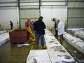
Fischauktion in Kinlochbervie
-

Sandwood Bay
Weblinks
 Commons: Kinlochbervie – Sammlung von Bildern, Videos und AudiodateienKategorie:
- Ort in der Unitary authority Highland
-


Wikimedia Foundation.