- Kettering (Borough)
-
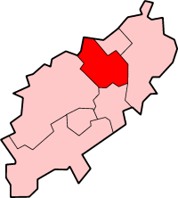
Borough of Kettering 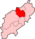
Lage in NorthamptonshireStatus Borough Region East Midlands Verw.grafschaft Northamptonshire Verwaltungssitz Kettering Fläche 233,49 km² (176.) Einwohner 89.500 (265.) ONS-Code 34UE Website www.kettering.gov.uk Kettering ist ein Verwaltungsbezirk mit dem Status eines Borough in der Grafschaft Northamptonshire in England. Verwaltungssitz ist die Stadt Kettering, in der etwas mehr als die Hälfte der Bevölkerung lebt. Weitere bedeutende Orte sind Barton Seagrave, Broughton, Burton Latimer, Geddington und Rothwell.
Corby | Daventry | East Northamptonshire | Kettering | Northampton | South Northamptonshire | Wellingborough
Wikimedia Foundation.
Schlagen Sie auch in anderen Wörterbüchern nach:
Kettering (borough) — Infobox UK district name = Borough of Kettering status = Borough region = East Midlands admincounty = Northamptonshire area = Ranked 176th 233.49 km² adminhq = Kettering onscode = 34UE population = Ranked English district rank|ONS=34UE English… … Wikipedia
Kettering Borough Council — is a local authority in Kettering Borough, composed of 45 local councillors and currently controlled by the Conservatives, who have controlled the Council since the 2003 local elections, where they gained control from Labour with a majority of 15 … Wikipedia
Kettering Borough Council elections, 2003 — Labour Majority of 1Ward by Ward Results =All Saints Ward (2 seats)= Election box begin title=Kettering Borough Council Elections 2003: All Saints WardElection box candidate with party link party = Conservative Party (UK) candidate = Greg… … Wikipedia
Kettering Borough Council elections, 2007 — Elections to Kettering Borough Council were held on 3rd May, 2007. The whole council was up for election with boundary changes since the last election in 2003 reducing the number of seats by nine. The Conservative Party retained overall control… … Wikipedia
Kettering Borough Council elections, 1999 — Elections to Kettering Borough Council were held on 6 May, 1999. The whole council was up for election and boundary changes had taken place since the last election in 1995. The Labour Party lost its overall majority, the council coming under no… … Wikipedia
Kettering local elections — Kettering Borough Council is elected every four years.Political control*1973 1983: No overall control *1983 1987: Conservative *1987 1995: No overall control *1995 1999: Labour *1999 2001: No overall control *2001 2003: Labour *2003 present:… … Wikipedia
Kettering (ville) — Pour les articles homonymes, voir Kettering. 52°23′50″N 0°43′13″O / … Wikipédia en Français
Kettering — ist die Bezeichnung mehrerer Orte in Australien: Kettering (Tasmanien), Gemeinde, deren Gebiet auch Bruny Island einschließt in Großbritannien: Kettering (Northamptonshire) Kettering (Borough), ein Bezirk mit Kettering als Hauptort in den USA:… … Deutsch Wikipedia
Kettering — Infobox UK place country = England official name = Kettering latitude = 52.39312 longitude = 0.72292 population = 51,063 [ [http://www.statistics.gov.uk/statbase/ssdataset.asp?vlnk=8271 More=Y 2001 urban areas headcounts] ] (2001) shire district … Wikipedia
Kettering (Angleterre) — Pour les articles homonymes, voir Kettering. 52°23′50″N 0°43′13″O / … Wikipédia en Français
Kettering (Borough)
18+
© Academic, 2000-2024
- Kontaktieren Sie uns: Unterstützung, Werbung
Wörterbücher Export, schritte mit PHP, Joomla, Drupal, WordPress, MODx.