Kempsey Shire

Kempsey Shire
Shire of Kempsey
Australia-Map-NSW-LGA-Kempsey.png
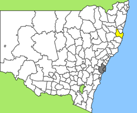
Lage des Kempsey Shire in New South Wales
Gliederung
Staat: Australien Australien
Bundesstaat: Flag of New South Wales.svg New South Wales
Verwaltungssitz: West Kempsey
Daten und Zahlen
Fläche: 3.380 km²
Einwohner: 27.387 (2006) [1]
Bevölkerungsdichte: 8,1 Einwohner je km²
-31.083333333333152.83333333333

Kempsey Shire ist ein lokales Verwaltungsgebiet (LGA) im australischen Bundesstaat New South Wales. Das Gebiet ist 2.301 km² groß und hat etwa 27.000 Einwohner.

Kempsey liegt im Osten des Staates an der Pazifikküste etwa 425 km nordöstlich der Metropole Sydney und 510 km südlich von Brisbane. Das Gebiet umfasst 114 Ortsteile und Ortschaften, darunter Arakoon, Bellbrook, Burnt Bridge, Clybucca, Comara, Crescent Head, Five Day Creek, Fredrickton, Gladstone, Grassy Head, Hat Head, Jerseyville, Kempsey, Kinchela, Millbank, Sherwood, Smithtown, Stuarts Point, Turners Flat und Willawarrin. Der Sitz des Shire Councils befindet sich im Stadtteil West Kempsey im Osten der LGA. Die Stadt Kempsey hat etwa 8.100 Einwohner.

Verwaltung

Der Kempsey Shire Council hat neun Mitglieder, die von den Bewohnern der LGA gewählt werden. Kempsey ist nicht in Bezirke untergliedert. Aus dem Kreis der Councillor rekrutiert sich auch der Mayor (Bürgermeister) des Councils.

Weblinks

Einzelnachweise

  1. Australian Bureau of Statistics (25. Oktober 2007): Kempsey (A) (Local Government Area) (Englisch). 2006 Census QuickStats. Abgerufen am 6. April 2010.

Wikimedia Foundation.

Игры ⚽ Поможем сделать НИР

Schlagen Sie auch in anderen Wörterbüchern nach:

  • Kempsey Shire Council — Infobox Australian Place | type = lga name = Kempsey Shire state = nsw caption = Location in New South Wales pop = 28,742 publisher = Australian Bureau of Statistics title=Regional Population Growth, Australia, 2004 05 url =… …   Wikipedia

  • Kempsey (New South Wales) — Kempsey Staat: Australien Bundesstaat …   Deutsch Wikipedia

  • Kempsey, New South Wales — Infobox Australian Place | type = town name = Kempsey state = nsw caption = lga = Kempsey Shire Council postcode = 2440 pop = 8,137 (City) Census 2006 AUS|id=UCL143000|name=Kempsey (Urban Centre/Locality)|accessdate = 2008 03 17|quick=on] 11,679… …   Wikipedia

  • Kempsey — /ˈkɛmpsi/ (say kempsee) noun a town and shire on the north coast of NSW, on the Macleay River. The Kempsey district is in territory traditionally inhabited by the Dhangadi people. European exploration dates from the 1820s. Kempsey began in 1836… …  

  • Wakool Shire — Shire of Wakool New South Wales Location in New South Wales Population: 4,427(2009) …   Wikipedia

  • Nambucca Shire — New South Wales Location in New South Wales Population: 19,186(200 …   Wikipedia

  • Nambucca Shire Council — Infobox Australian Place | type = lga name = Nambucca Shire state = nsw caption = Location in New South Wales pop = 18,755cite web publisher = Australian Bureau of Statistics title=Regional Population Growth, Australia, 2004 05 url =… …   Wikipedia

  • Muswellbrook Shire — New South Wales Location in New South Wales Population …   Wikipedia

  • Conargo Shire — New South Wales Location in New South Wales Population: 1,700(2009) …   Wikipedia

  • Cowra Shire — New South Wales Location in NSW Population: 12,945(2009) …   Wikipedia

Share the article and excerpts

Direct link
Do a right-click on the link above
and select “Copy Link”