- Kasama (Ibaraki)
-
Kasama-shi
笠間市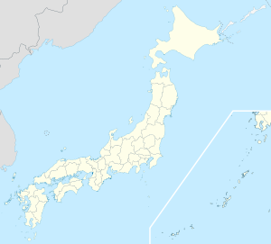

Geographische Lage in Japan Region: Kantō Präfektur: Ibaraki Koordinaten: 36° 21′ N, 140° 18′ O36.3453140.30436111111Koordinaten: 36° 20′ 43″ N, 140° 18′ 16″ O Basisdaten Fläche: 240,25 km² Einwohner: 78.965
(1. Juli 2011)Bevölkerungsdichte: 329 Einwohner je km² Gemeindeschlüssel: 08216-3 Rathaus Adresse: Kasama City Hall
3-2-1, Chūō
Kasama-shi
Ibaraki 309-1792Webadresse: http://www.city.kasama.lg.jp Lage Kasamas in der Präfektur Ibaraki 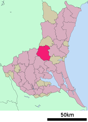
Kasama (jap. 笠間市, -shi) ist eine Stadt in der Präfektur Ibaraki in Japan.
Inhaltsverzeichnis
Geographie
Kasama liegt westlich von Mito und nördlich von Tsuchiura.
Geschichte
Kasama erhielt am 1. August 1958 das Stadtrecht.
Sehenswürdigkeiten
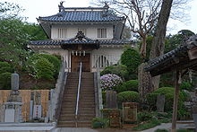
- Burg Kasama (笠間城, Kasama-jō)
Verkehr
- Zug:
- Straße:
- Jōban-Autobahn, nach Tokio und Iwaki
- Kitakantō-Autobahn
- Nationalstraße 50, nach Maebashi und Mito
Angrenzende Städte und Gemeinden
Weblinks
 Commons: Kasama – Sammlung von Bildern, Videos und Audiodateien
 Gemeinden und Landkreise in der Präfektur Ibaraki
Kreisfreie Städte (shi): Bandō | Chikusei | Hitachi | Hitachinaka | Hitachi-Ōmiya | Hitachi-Ōta | Hokota | Inashiki | Ishioka | Itako | Jōsō | Kamisu | Kasama | Kashima | Kasumigaura | Kitaibaraki | Koga | Moriya | Mito (Verwaltungssitz) | Naka | Namegata | Omitama | Ryūgasaki | Sakuragawa | Shimotsuma | Takahagi | Toride | Tsuchiura | Tsukuba | Tsukubamirai | Ushiku | Yūki
Higashiibaraki-gun: Ibaraki | Oarai | Shirosato | Inashiki-gun: Ami | Kawachi | Miho | Kitasouma-gun: Tone | Kuji-gun: Daigo | Naka-gun: Tōkai | Sashima-gun: Goka | Sakai | Yūki-gun: Yachiyo
Wikimedia Foundation.
Schlagen Sie auch in anderen Wörterbüchern nach:
Kasama, Ibaraki — nihongo|Kasama|笠間市|Kasama shi is a city located in Ibaraki, Japan.As of 2003, the city has an estimated population of 29,776 and the density of 226.24 persons per km². The total area is 131.61 square kilometres. Kasama officially achieved city… … Wikipedia
Kasama — The toponym Kasama may refer to:*Kasama, Ibaraki, Japan *Kasama, Zambia … Wikipedia
Kasama Domain — nihongo|Kasama Domain|笠間藩|Kasama han| was a Japanese domain of the Edo period, located in Hitachi Province (modern day Kasama, Ibaraki).List of lords*Matsudaira (Matsui) clan#Yasushige*Ogasawara clan (Fudai; 30,000 koku)#Yoshitsugu* Tenryō… … Wikipedia
Ibaraki Prefecture — Infobox Prefecture Japan Name = Ibaraki JapaneseName = 茨城県 Rōmaji = Ibaraki ken Symbol = Symbol of Ibaraki Prefecture.svg Capital = Mito Region = Kantō Island = Honshū TotalArea = 6,095.58 AreaRank = 23rd PCWater = 4.8 PopDate = October 1, 2000… … Wikipedia
Kita-Ibaraki — 北茨城市 Kita Ibaraki shi Geographische Lage in Japan … Deutsch Wikipedia
Prefectura de Ibaraki — Ibaraki 茨城県 Ibaraki ken Prefectura de Japón … Wikipedia Español
Nishiibaraki District, Ibaraki — Nishiibaraki (西茨城郡; gun), literally West Ibaraki, was a district located in Ibaraki, Japan. As of 2004, the district has an estimated population of 52,291. The total area was 108.64 km². There were two municipalities before the dissolution… … Wikipedia
Iwama, Ibaraki — nihongo|Iwama|岩間町|Iwama machi is a small town in Nishi ibaraki District, Ibaraki, Japan. On March 19, 2006, Iwama joined with Tomobe to merge with Kasama to form the new city of Kasama.GeographyIwama is located about 100 km northeast of Tokyo and … Wikipedia
Tomobe, Ibaraki — Tomobe (友部町; machi) was a town located in Nishiibaraki District, Ibaraki, Japan.As of 2003, the town had an estimated population of 35,657 and a density of 607.34 persons per km². The total area is 58.71 km².On March 19, 2006, Tomobe joined with… … Wikipedia
Präfektur Ibaraki — 茨城県 Präfektur Ibaraki Basisdaten Verwaltungssitz: Mito Region … Deutsch Wikipedia
Kasama (Ibaraki)


18+
© Academic, 2000-2024
- Kontaktieren Sie uns: Unterstützung, Werbung
Wörterbücher Export, schritte mit PHP, Joomla, Drupal, WordPress, MODx.