Kangaroo Island Council

Kangaroo Island Council
District Council of Kangaroo Island
Australia-Map-SA-LGA-KangarooIsland.png
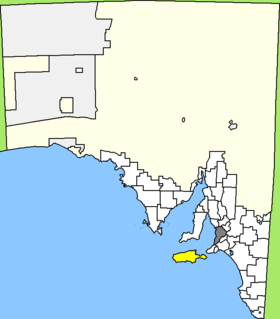
Lage des Kangaroo Island Council in South Australia
Gliederung
Staat: Australien Australien
Bundesstaat: Flag of South Australia.svg South Australia
Verwaltungssitz: Kingscote
Daten und Zahlen
Fläche: 4.400 km²
Einwohner: 4.259 (2006) [1]
Bevölkerungsdichte: 1 Einwohner je km²
-35.65137.63333333333

Der District Council of Kangaroo Island ist ein lokales Verwaltungsgebiet (LGA) im australischen Bundesstaat South Australia. Das Gebiet ist 4400 km² groß und hat etwa 4400 Einwohner.

Kangaroo Island ist eine Insel vor der südaustralischen Küste vor dem Gulf Saint Vincent und ist etwa 110 km von der Metropole Adelaide entfernt. Auf der Insel liegen 19 Ortsteile und Ortschaften: American Beach, American River, Antechamber Bay, Brownlow, Cygnet River, Emu Bay, Flinders Chase, Harriet, Island Beach, Karatta, Kingscote, MacGillivray, Nepean Bay, Parndana, Penneshaw, Sapphiretown, Stokes Bay, Vivonne Bay und Wisanger. Der Verwaltungssitz des Councils befindet sich in Kingscote an der Nordostküste der Insel.

Verwaltung

Der Council von Kangaroo Island hat zehn Mitglieder, die neun Councillor und der Vorsitzende und Mayor (Bürgermeister) des Councils werden von den Bewohnern der LGA gewählt. Kangaroo Island ist nicht in Bezirke untergliedert.

Weblinks

Einzelnachweise

  1. Australian Bureau of Statistics (25. Oktober 2007): Kangaroo Island (DC) (Local Government Area) (Englisch). 2006 Census QuickStats. Abgerufen am 6. April 2010.

Wikimedia Foundation.

Игры ⚽ Нужно сделать НИР?

Schlagen Sie auch in anderen Wörterbüchern nach:

  • Kangaroo Island Council — Infobox Australian Place | type = lga name = Kangaroo Island Council state = sa caption = Location of Kangaroo Island Council pop = 4,384 (2001 census) density = area = 4400.1 est = 1996 seat = Kingscote mayor = Jayne Bates region = Kangaroo… …   Wikipedia

  • Kangaroo Island — For other places with the same name, see Kangaroo Island (disambiguation). Kangaroo Island Native name: Karta (Island of the Dead) Map of Kangaroo Island …   Wikipedia

  • Kangaroo Island — Blick über den Ostteil der Insel von einem Sandberg an ihrer engsten Stelle Lage der Insel …   Deutsch Wikipedia

  • Island Beach, South Australia — Island Beach is a 4 km white sand swimming beach in Eastern Cove approximately 15 minutes from Penneshaw, South Australia, and approximately 45 minutes from Kingscote. Island Beach has a small permanent population, and many rental houses.John… …   Wikipedia

  • District Council of Yankalilla — South Australia Location of the District Council of Yankalilla Population …   Wikipedia

  • Council Grounds State Park — Coordinates: 45°11′7″N 89°44′35″W / 45.18528°N 89.74306°W / 45.18528; 89.74306 …   Wikipedia

  • District Council of Lower Eyre Peninsula — South Australia Location of the District Council of Lower Eyre Peninsula …   Wikipedia

  • District Council of Barunga West — South Australia Location of the District Council of Barunga West Population …   Wikipedia

  • District Council of Yorke Peninsula — South Australia Location of the District Council of Yorke Peninsula Population …   Wikipedia

  • District Council of Loxton Waikerie — South Australia Location of the District Council of Loxton Waikerie Population …   Wikipedia

Share the article and excerpts

Direct link
Do a right-click on the link above
and select “Copy Link”