- Kami-Amakusa
-
Kami-Amakusa-shi
上天草市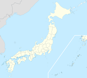

Geographische Lage in Japan Region: Kyūshū Präfektur: Kumamoto Koordinaten: 32° 35′ N, 130° 26′ O32.587444444444130.43044444444Koordinaten: 32° 35′ 15″ N, 130° 25′ 50″ O Basisdaten Fläche: 126,06 km² Einwohner: 29.379
(1. Juli 2011)Bevölkerungsdichte: 233 Einwohner je km² Gemeindeschlüssel: 43212-1 Symbole Baum: Kiefer Blume: Kirschblüte Vogel: Zosterops japonicus Rathaus Adresse: Kami-Amakusa City Hall
1514 Kami, Ōyano-machi
Kami-Amakusa-shi
Kumamoto 869-3692Webadresse: http://www.kamiamakusa-c.kumamoto-sgn.jp Lage Kami-Amakusas in der Präfektur Kumamoto 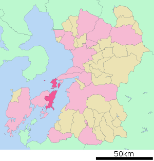
Kami-Amakusa (jap. 上天草市, -shi) ist eine japanische Stadt in der Präfektur Kumamoto auf den Amakusa-Inseln.
Inhaltsverzeichnis
Geschichte
Die Stadt wurde am 31. März 2004 durch die Zusammenlegung der Gemeinden Himedo (姫戸町, -machi), Matsushima (松島町, -machi), Ōyano (大矢野町, -machi) und Ryūgatake (龍ヶ岳町, -machi) des Landkreises Amakusa gegründet.
Verkehr
- Straße:
- Nationalstraße 266, 324
Söhne und Töchter der Stadt
- Amakusa Shirō (Der Führer des Shimabara-Aufstandes)
Angrenzende Städte und Gemeinden
Weblinks
 Commons: Kami-Amakusa – Sammlung von Bildern, Videos und Audiodateien
 Gemeinden und Landkreise in der Präfektur Kumamoto
Kreisfreie Städte (shi): Amakusa | Arao | Aso | Hitoyoshi | Kami-Amakusa | Kikuchi | Kōshi | Kumamoto (Verwaltungssitz) | Minamata | Tamana | Uki | Uto | Yamaga | Yatsushiro
Amakusa-gun: Reihoku | Ashikita-gun: Ashikita | Tsunagi | Aso-gun: Minamiaso | Minamioguni | Nishihara | Oguni | Takamori | Ubuyama | Kamimashiki-gun: Kashima | Kosa | Mashiki | Mifune | Yamato | Kikuchi-gun: Kikuyō | Ōzu | Kuma-gun: Asagiri | Itsuki | Kuma | Mizukami | Nishiki | Sagara | Taragi | Yamae | Yunomae | Shimomashiki-gun: Misato | Tamana-gun: Gyokutō | Nagasu | Nagomi | Nankan | Yatsushiro-gun: Hikawa
Wikimedia Foundation.
Schlagen Sie auch in anderen Wörterbüchern nach:
Kami-Amakusa, Kumamoto — nihongo|Kami Amakusa|上天草市|Kami amakusa shi is a city located in Kumamoto Prefecture, Japan. It was founded on March 31, 2004, by merging the three cities Himedo, Matsushima and Ryugatake.As of 2005, the city has an estimated population of 35,314… … Wikipedia
Amakusa (Kumamoto) — Amakusa shi 天草市 … Deutsch Wikipedia
Amakusa-Inseln — Die Amakusa Inseln (jap. 天草諸島, shōtō) sind eine zu Japan gehörende Inselgruppe. Sie liegen westlich vor der Präfektur Kumamoto und zwischen der Ariake See und der Yatsushiro See. Die größten Inseln sind: Kami shima ( … Deutsch Wikipedia
Amakusa District, Kumamoto — Amakusa (天草郡; gun) is a district located in Kumamoto Prefecture, Japan.Following the March 27, 2006 Amakusa merger the district consists of the single town of Reihoku. After the merger, the district has an estimated population of 9,105 and a… … Wikipedia
Amakusa Shirō — In this Japanese name, the family name is Amakusa . Statue of Amakusa Shirō at Hara Castle Amakusa Shirō (天草 四郎 … Wikipedia
Amakusa Shirō — Este artículo está titulado de acuerdo a la onomástica japonesa, en que el apellido precede al nombre. Estatua de Amakusa Shirō en el Castillo Hara. Amakusa Shirō (天草 四郎 … Wikipedia Español
Amakusa-shima — [ ʃima], die japanischen Inseln Shimo (571 km2) und Kami (225 km2) sowie etwa 70 Nebeninseln, in der Amakusasee südöstlich von Nagasaki; Steinkohlenbergbau und Anbau von Zitrusfrüchten; Teil des Unsen Amakusa Nationalparks mit regem… … Universal-Lexikon
Amakusa Islands — ▪ archipelago, Japan Japanese Amakusa shotō, archipelago off western Kyushu, Japan, in the Amakusa Sea. Administered by Kumamoto ken (prefecture), it includes about 100 islands, the largest of which are Kami (“Upper”) Island and Shimo… … Universalium
Islas Amakusa — Puesta de sol desde los Cinco Puentes de Amakusa, Kumamoto. Localización geográfica / administrativa … Wikipedia Español
Kamiamakusa — 上天草市 Kami Amakusa shi … Deutsch Wikipedia
- Straße:
Kami-Amakusa


18+
© Academic, 2000-2024
- Kontaktieren Sie uns: Unterstützung, Werbung
Wörterbücher Export, schritte mit PHP, Joomla, Drupal, WordPress, MODx.