- Kabacan
-
Municipality of Kabacan Lage von Kabacan in der Provinz Cotabato 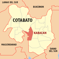
Basisdaten Bezirk: SOCCSKSARGEN Provinz: Cotabato Barangays: 24 Distrikt: 1. Distrikt von Cotabato PSGC: 124703000 Einkommensklasse: 1. Einkommensklasse Haushalte: 12.663 Zensus 1. Mai 2000Einwohnerzahl: 73.991 Zensus 1. August 2007Koordinaten: 7° 7′ N, 124° 49′ O7.1166666666667124.81666666667Koordinaten: 7° 7′ N, 124° 49′ O Postleitzahl: 9407 Bürgermeister: George B. Tan Geographische Lage auf den Philippinen 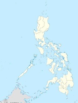

Kabacan Kabacan ist eine philippinische Stadtgemeinde in der Provinz Cotabato. Nach dem Zensus vom 1. Mai 2000 hat sie 61.998 Einwohner in 12.663 Haushalten.
Baranggays
Kabacan ist politisch in 24 Baranggays unterteilt.
- Aringay
- Bangilan
- Bannawag
- Buluan
- Cuyapon
- Dagupan
- Katidtuan
- Kayaga
- Kilagasan
- Magatos
- Malamote
- Malanduague
- Nanga-an
- Osias
- Paatan Lower
- Paatan Upper
- Pedtad
- Pisan
- Poblacion
- Salapungan
- Sanggadong
- Simbuhay
- Simone
- Tamped
Schlagen Sie auch in anderen Wörterbüchern nach:
Kabacan — Original name in latin Kabacan Name in other language Kabacan, Kabakan State code PH Continent/City Asia/Manila longitude 7.10667 latitude 124.82917 altitude 24 Population 31769 Date 2011 07 31 … Cities with a population over 1000 database
Kabacan, Cotabato — Kabacan is a 2nd class municipality in the province of Cotabato, Philippines. According to the 2000 census, it has a population of 61,998 people in 12,663 households.The town is predominantly composed of rice farms made possible by the influx of… … Wikipedia
Matalam, Cotabato — Matalam Municipality Municipality of Matalam, Cotabato Map of Cotabato showing the location of Matalam … Wikipedia
Battle of Mindanao — Infobox Military Conflict conflict=Battle of Mindanao caption=Reconquest of Mindanao Map partof=World War II, Pacific theater date=10 March – 15 August 1945 place=Mindanao Island, Philippines result=Allied victory combatant1= flagicon|United… … Wikipedia
Cotabato — This article is about a province in the Philippines. For the city of the same name surrounded by the province of Maguindanao, see Cotabato City. For other uses, see Cotabato (disambiguation). Cotabato Province … Wikipedia
Magpet, Cotabato — Magpet Municipality Municipality of Magpet, Cotabato Map of Cotabato showing the location of Mag … Wikipedia
Midsayap, Cotabato — Midsayap Municipality Municipality of Midsayap, Cotabato Map of Cotabato showing the locatio … Wikipedia
Sayre Highway — Infobox road marker state= highway name=Sayre Highway name notes= route= alternate name= maint= section= length km=192 length round=1 length ref= length notes= established= decommissioned= direction a=North terminus a=Puerto, Cagayan de Oro City … Wikipedia
PH-NCO — Lage der Provinz Cotabato Die Provinz Cotabato, zuvor unter dem Namen North Cotabato geführt, ist eine Provinz des Inselstaates der Philippinen und befindet sich im Zentrum der Insel Mindanao. Sie besitzt als eine der wenigen Provinzen des Landes … Deutsch Wikipedia
Rio Grande de Mindanao — Das Einzugsgebiet des Rio Grande de Mindanao DatenVorlage:In … Deutsch Wikipedia
Kabacan


18+
© Academic, 2000-2024
- Kontaktieren Sie uns: Unterstützung, Werbung
Wörterbücher Export, schritte mit PHP, Joomla, Drupal, WordPress, MODx.