- Amund Ringnes Island
-
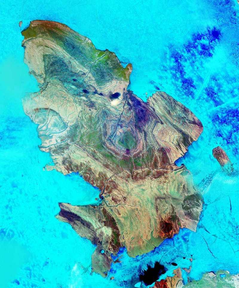
Amund Ringnes Island Satellitenbild von Amund Ringnes Island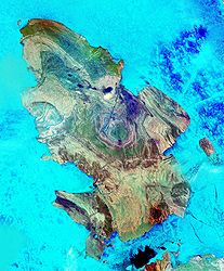
Gewässer Arktischer Ozean Inselgruppe Königin-Elisabeth-Inseln Geographische Lage 78° 16′ 26″ N, 96° 37′ 45″ W78.273888888889-96.629166666667265Koordinaten: 78° 16′ 26″ N, 96° 37′ 45″ W 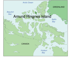
Fläche 5.255 km² Höchste Erhebung (unbenannt)
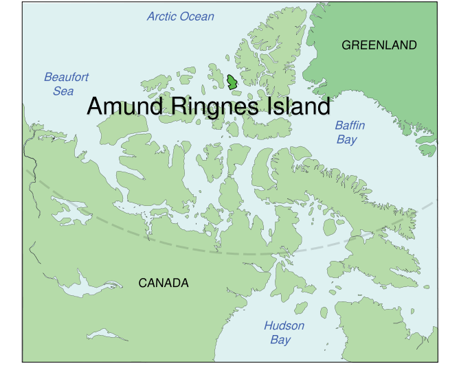
265 mEinwohner (unbewohnt) Amund Ringnes Island ist eine Insel im kanadischen Territorium Nunavut und gehört zu den Königin-Elisabeth-Inseln. Sie Insel liegt östlich von Ellef Ringnes Island, westlich von Axel Heiberg Island und nördlich von Cornwall Island. Sie hat eine Fläche von 5255 km² und erreicht eine Höhe von 265 m über dem Meer.
Die Insel wurde am 20. April 1900 von Gunnerius Ingvald Isachsen, einem Mitglied der von Otto Sverdrup geleiteten Zweiten Fram-Expedition (1898–1902), entdeckt und nach Amund Ringnes (1840–1907), einem Mitbegründer der norwegischen Brauerei Ringnes, die die Expedition mitfinanzierte, benannt.
1916 wurde die Insel von Vilhjalmur Stefansson vermessen, der auch Vorkommen von Kohle und Gips auf der Insel fand.
Hauptinseln der Königin-Elisabeth-InselnEllesmere Island
Parry-Inseln: Devon Island | Melville-Insel | Bathurst Island | Prinz-Patrick-Insel | Cornwallis Island | Mackenzie-King-Insel | Borden-Insel | Cornwall Island | Eglinton Island | Graham Island | Lougheed Island | Byam Martin Island | Île Vanier | Cameron Island | Meighen Island | Brock-Insel | North Kent Island | Emerald Isle | Alexander Island | Massey Island | Little Cornwallis Island | Coburg Island | Helena Island | Baillie-Hamilton Island | Griffith Island | Hoved Island | Lowther Island | Buckingham Island
Sverdrup-Inseln: Axel Heiberg Island | Ellef Ringnes Island | Amund Ringnes Island | King Christian Island | Stor Island
Wikimedia Foundation.
Schlagen Sie auch in anderen Wörterbüchern nach:
Amund Ringnes Island — [ aːmʊn rɪȖneɪs aɪlənd], unbewohnte Insel der Sverdrup Islands im Kanadisch Arktischen Archipel, 5 255 km2. 1900 entdeckt … Universal-Lexikon
Amund Ringnes Island — Infobox Islands name = Amund Ringnes Island image caption = Amund Ringnes Island from space image size = locator map custom = no native name = native name link = Inuktikut nickname = location = Northern Canada coordinates =… … Wikipedia
Amund Ringnes Island — Sp Ãmundo Ringneso salà Ap Amund Ringnes Island L Arkties vand., Sverdrupo ss., Kanada (Nunavutas) … Pasaulio vietovardžiai. Internetinė duomenų bazė
Amund-Ringnes-Insel — Die Amund Ringnes Insel Die Amund Ringnes Insel (engl. Amund Ringnes Island) gehört zu den Königin Elisabeth Inseln im Territorium Nunavut, Kanada. Sie liegt östlich der Ellef Ringnes Insel und westlich der Axel Heiberg Insel und hat eine Fläche… … Deutsch Wikipedia
Ellef Ringnes Island — Infobox Islands name = Ellef Ringnes Island image caption = Closeup of Ellef Ringnes Island and neighbouring islands image size = locator map custom = no native name = native name link = Inuktikut nickname = location = Northern Canada coordinates … Wikipedia
Ellef Ringnes Island — Satellitenbild Gewässer Arktischer Ozean Inselgruppe … Deutsch Wikipedia
Isla Amund Ringnes — (Amund Ringnes Island) Localización País … Wikipedia Español
Île Amund Ringnes — 77° 53′ 00″ N 95° 30′ 00″ W / 77.883333, 95.5 … Wikipédia en Français
Ringnes — is the largest brewer in Norway. It was founded in 1876 by brothers Amund and Ellef Ringnes (Amund was the brewer, Ellef the administrator and salesman) and financial director Axel Heiberg. The company s brewery in the Grünerløkka district of… … Wikipedia
Cornwall Island (Nunavut) — Cornwall Island Cornwall Island, Nunavut Geography Location Northern Canada Coordinates … Wikipedia
Amund Ringnes Island
18+
© Academic, 2000-2024
- Kontaktieren Sie uns: Unterstützung, Werbung
Wörterbücher Export, schritte mit PHP, Joomla, Drupal, WordPress, MODx.