- Amphoe Phanat Nikhom
-
Phanat Nikhom
พนัสนิคมProvinz: Chonburi Fläche: 450,9 km² Einwohner: 116.439 (2005) Bev.dichte: 258,2 E./km² PLZ: 20140 Geocode: 2006 Karte 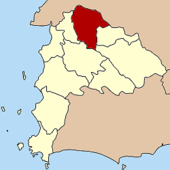
Amphoe Phanat Nikhom (Thai: อำเภอ พนัสนิคม) ist ein Landkreis (Amphoe - Verwaltungs-Distrikt) im Norden der Provinz Chonburi. Die Provinz Chonburi liegt in der Ostregion von Zentralthailand.
Inhaltsverzeichnis
Geographie
Die benachbarten Amphoe sind im Uhrzeigersinn von Osten aus: die Amphoe Ko Chan, Bo Thong, Ban Bueng und Phan Thong in der Provinz Chonburi sowie die Amphoe Ban Pho und Plaeng Yao in der Provinz Chachoengsao).
Geschichte
Die Gegend war bereits vor Jahrtausenden besiedelt, wie Ausgrabungen in Nong Nor und Khok Phanom Di gezeigt haben. Phanat Nikhom selbst ist eine alte Ansiedlung, die bis zurück zum Reich der Khmer datiert werden kann. Archäologen fanden Ruinen einer Stadtbefestigung im Landkreis. In der Rattanakosin-Periode gründete König Nang Klao (Rama III.) Im Jahr 1828 die Stadt (Mueang) Phanat Nikhom. Im Jahr 1904 wurde sie von König Chulalongkorn (Rama V.) zu einem Landkreis der Provinz Chonburi gemacht.
Archäologie
- Nong Nor – archäologischer Fundplatz in der Schwemmlandebene des Flusses Bang Pakong,
- Khok Phanom Di – archäologischer Fundplatz etwa 14 km nördlich von Nong Nor.
Verwaltung
Der Kreis ist in 20 Kommunen (Tambon) eingeteilt, die sich weiter in 185 Dörfer (Muban) unterteilen.
Phanat Nikhom selbst (Thai: เทศบาลเมืองบ้านบึง) hat einen Stadt-Status (Thesaban Mueang) und besteht aus dem gesamten Tambon Phanat Nikhom.
Es gibt weiterhin eine Kleinstadt (Thesaban Tambon) im Landkreis:
- Mon Nang (เทศบาลตำบลหมอนนาง), besteht aus dem gesamten Tambon Mon Nang.
Die untere Verwaltungsebene bilden 19 Tambon („Tambon Administrative Organizations“ - TAO, Thai: องค์การบริหารส่วนตำบล):
Nr. Name Thai Einw. 1. Phanat Nikhom พนัสนิคม 11.912 2. Na Phrathat หน้าพระธาตุ 4.840 3. Wat Luang วัดหลวง 2.781 4. Ban Soet บ้านเซิด 3.369 5. Na Roek นาเริก 8.821 6. Mon Nang หมอนนาง 13.614 7. Sa Si Liam สระสี่เหลี่ยม 6.772 8. Wat Bot วัดโบสถ์ 3.054 9. Kut Ngong กุฎโง้ง 5.283 10. Hua Thanon หัวถนน 4.890 11. Tha Kham ท่าข้าม 2.882 13. Nong Prue หนองปรือ 5.232 14. Nong Khayat หนองขยาด 4.028 15. Thung Khwang ทุ่งขวาง 4.158 16. Nong Hiang หนองเหียง 12.924 17. Na Wang Hin นาวังหิน 7.047 18. Ban Chang บ้านช้าง 5.936 20. Khok Phlo โคกเพลาะ 2.746 21. Rai Lak Thong ไร่หลักทอง 3.386 22. Na Matum นามะตูม 2.764 Fehlende Geocodes beziehen sich auf die Tambon, aus denen heute Ko Chan besteht.
Weblinks
Mueang Chonburi | Ban Bueng | Nong Yai | Bang Lamung | Phan Thong | Phanat Nikhom | Si Racha | Ko Sichang | Sattahip | Bo Thong | Ko Chan
Wikimedia Foundation.
Schlagen Sie auch in anderen Wörterbüchern nach:
Amphoe Phanat Nikhom — Admin ASC 2 Code Orig. name Amphoe Phanat Nikhom Country and Admin Code TH.46.1607837 TH … World countries Adminstrative division ASC I-II
Amphoe Phanat Nikhom — Infobox Amphoe name=Phanat Nikhom thai=พนัสนิคม province=Chonburi coordinates=coord|13|27|8|N|101|10|38|E|type:adm2nd region:TH area=450.9 population=116,439 population as of=2005 density=258.2 postal code=20140 geocode=2006Phanat Nikhom ( th.… … Wikipedia
Amphoe Phanat Nikhom — Phan Nikhom พนัสนิคม Localisation du district. Administration Pays Thaïlande … Wikipédia en Français
Phanat Nikhom — Original name in latin Phanat Nikhom Name in other language Amphoe Phanat Nikhom, Amphu Panas Nikom, Ban Phanat Nikhom, Bhanasnigom, Mueang Phanat Nikhom, Phanat Nikhom, Phanatikhom, phnasnikhm State code TH Continent/City Asia/Bangkok longitude… … Cities with a population over 1000 database
Amphoe Bo Thong — Bo Thong บ่อทอง Provinz: Chonburi Fläche: 781,6 km² Einwohner: 45.547 (2005) Bev.dichte: {{{Bevölkerungsdichte}}} E./km² PLZ … Deutsch Wikipedia
Amphoe Ko Chan — Ko Chan อำเภอเกาะจันทร์ Provinz: Chonburi Fläche: 248,8 km² Einwohner: 34.671 (2005) Bev.dichte: 139,4 E./km² PLZ: 20240 … Deutsch Wikipedia
Amphoe Phan Thong — Phan Thong พานทอง Provinz: Chonburi Fläche: 173,0 km² Einwohner: 44.859 (2000) Bev.dichte: 259 E./km² PLZ: 20160 … Deutsch Wikipedia
Amphoe Ban Pho — Ban Pho บ้านโพธิ์ Provinz: Chachoengsao Fläche: 217,593 km² Einwohner: 45.477 (2000) Bev.dichte: 209 E./km² PLZ: 24140 … Deutsch Wikipedia
Amphoe Ban Bueng — Ban Bueng บ้านบึง Provinz: Chonburi Fläche: 646,3 km² Einwohner: 93.401 (2005) Bev.dichte: 144,5 E./km² PLZ: 20170 … Deutsch Wikipedia
Amphoe Bo Thong — Infobox Amphoe name=Bo Thong thai=บ่อทอง province=Chonburi coordinates=coord|13|16|43|N|101|26|25|E|type:adm2nd region:TH area=781.6 population=45,547 population as of=2005 density=58.3 postal code=20270 geocode=2010Bo Thong ( th. บ่อทอง) is a… … Wikipedia
Amphoe Phanat Nikhom

18+
© Academic, 2000-2024
- Kontaktieren Sie uns: Unterstützung, Werbung
Wörterbücher Export, schritte mit PHP, Joomla, Drupal, WordPress, MODx.