- Isle of Mull
-
Isle of Mull Die typische Landschaft Mulls im Frühjahr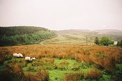
Gewässer Atlantischer Ozean Inselgruppe Innere Hebriden Geographische Lage 56° 26′ 56″ N, 5° 59′ 33″ W56.448888888889-5.9925966Koordinaten: 56° 26′ 56″ N, 5° 59′ 33″ W 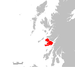
Fläche 875,35 km² Höchste Erhebung Ben More
966 mEinwohner 2.667 (2001)
3 Einw./km²Hauptort Tobermory Blick auf den Hauptort Tobermory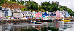
Isle of Mull (schottisch-gälisch: Eilean Muile oder
 Muile?/i; kurz auch Mull) ist eine Insel der Inneren Hebriden vor der Nordwestküste Schottlands, die zum Argyll & Bute Council gehört.
Inhaltsverzeichnis
Geographie
Die höchste Erhebung der Insel ist der 966 Meter hohe Ben More. Das Zentrum der Insel ist Tobermory mit etwa 990 Einwohnern (Schätzung 2004[1]). Insgesamt leben auf der Insel etwa 2700 Menschen.
Geologie
Die gesamte Insel ist das Resultat der langwährenden Erosion der letzten 30 bis 40 Millionen Jahre. Sie besteht größtenteils aus Basalt. Das Alumosilikat Mullit, ein wichtiger Rohstoff in der Keramikindustrie, wurde nach der Insel Mull benannt, da das Mineral 1924 hier erstmals entdeckt wurde.
Geschichte
Mikrolithen belegen, dass Mull seit ca. 6000 v. Chr. (Mesolithikum) besiedelt war. Während der Stein- oder Bronzezeit erbauten die Bewohner unter anderem das Steinfort Dun Ara, einen Steinkreis (Loch Blue Circle), vier Steinreihen und errichteten mehr als ein Dutzend Menhire. In der Eisenzeit entstanden zwei Brochs. Später folgten die Burgen Aros, Ardtornish, Calgary, Duart, Dunstaffnage, Dunollie, Glengorm, Mingary, Moy und Torosay (mit Gärten).
Im 14. Jahrhundert wurde Mull ein Teil der starken Lordship of the Isles. Nach dem Zusammenbruch der Lordship im Jahre 1493 wurde die Herrschaft der Insel durch den Clan der MacLean, die in Duart Castle residierten, übernommen. 1681 wurde er vom Clan der Campbells abgelöst. Während der Clearances im 18. und 19. Jahrhundert sank die Zahl der Bewohner von 10.000 auf unter 4.000.
Infrastruktur
Inzwischen ist Mull eine touristisch gut erschlossene Insel und eine Zwischenstation für zahlreiche Pilger, die über Mull nach Iona gelangen. Vom Fährhafen aus fahren Reisebusse über die Insel. Die Straßen sind meist einspurig.
Mull ist per Fähre von Oban, Lochaline und Ardnamurchan aus zu erreichen. Von Mull aus verkehren Ausflugsboote zu den kleinen Inseln Iona und Staffa. Von 1983 bis 2010 war die Miniatureisenbahn Isle of Mull Railway zwischen Craignure und Torosay Castle in Betrieb.
Hier geborene Persönlichkeiten
- Lachlan Macquarie, Gouverneur der britischen Kolonie New South Wales
Literatur
- A. de Watteville: The Isle of Mull, 1994
Weblinks
 Commons: Isle of Mull – Sammlung von Bildern, Videos und Audiodateien
Quellen
- ↑ General Register Office for Scotland: http://www.gro-scotland.gov.uk/statistics/publications-and-data/settlements-and-localities/mid-2004-population-estimates-for-settlements-in-scotland.html Mid-2004 Population Estimates for Settlements in Scotland
Schlagen Sie auch in anderen Wörterbüchern nach:
Isle of Mull — Mull redirects here. For other uses, see Mull (disambiguation). Isle of Mull Location OS grid reference … Wikipedia
Isle Of Mull — Original name in latin Isle Of Mull Name in other language State code GB Continent/City Europe/London longitude 56.44689 latitude 5.77126 altitude 376 Population 2667 Date 2012 04 12 … Cities with a population over 1000 database
Isle of Mull Railway — Streckenlänge: 2 km Spurweite: 260 mm Schottland: Isle of Mull Betriebsstellen Legende … Deutsch Wikipedia
Isle of Mull Hotel (Isle of Mull) — Isle of Mull Hotel country: United Kingdom, city: Isle of Mull (Craignure) Isle of Mull Hotel Location Situated on Craignure Bay on the Sound of Mull, the hotel has its own gardens that run down to the shore.Rooms The rooms are standardized and… … International hotels
Isle of Mull (United Kingdom) — Hotels: Isle of Mull Hotel (Craignure) … International hotels
Isle of Mull Railway — The Isle of Mull Railway is a 10¼ (260mm) gauge line, 1¼ miles long, from the ferry terminal at Craignure to Torosay Castle, on the Isle of Mull in the Scottish Inner Hebrides. Originally it was known as the Mull and West Highland Railway.This… … Wikipedia
MV Isle of Mull — Le MV Isle of Mull amarré à Craignure Type Ferry Histoire Lancement 8 décembre 1987 Mise en service … Wikipédia en Français
MV Isle of Mull — is one of the larger Caledonian MacBrayne ferries operating from Oban on the west of Scotland. HistoryMV Isle of Mull was designed for the route between Oban and Craignure on the Isle of Mull. After being launched on the Clyde in 1987, she… … Wikipedia
Mull Little Theatre — began as the Thursday Theatre, an entertainment for the paying guests of the Druimard Guest House on the Isle of Mull in the Inner Scottish Hebrides. Built from the shell of an old byre (cowshed) in 1963 by Barrie and Marianne Hesketh, it grew in … Wikipedia
Mull (disambiguation) — Mull may refer to: Contents 1 Places 2 People 3 Other uses 4 See also Places Isle of Mull, Scottish island in the Inner … Wikipedia
Isle of Mull


18+
© Academic, 2000-2024
- Kontaktieren Sie uns: Unterstützung, Werbung
Wörterbücher Export, schritte mit PHP, Joomla, Drupal, WordPress, MODx.