- Hope Bay
-
-63.383333333333-56.983333333333Koordinaten: 63° 23′ 0″ S, 56° 59′ 0″ W

Hope Bay Antarktis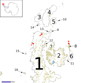 Karte der Antarktischen Halbinsel und der zugehörigen Inseln. A zeigt die Esperanza-Station an der Hope Bay
Die Hope Bay (Spanisch: Bahía Esperanza) an der Trinity Peninsula ist eine 5 Kilometer lange und 3 Kilometer weite Bucht; sie schneidet in die Spitze der Antarktischen Halbinsel ein und öffnet sich zum Antarctic Sound.
Die Bucht wurde am 15. Januar 1902 von der Schwedischen Antarktisexpedition unter Otto Nordenskjöld entdeckt, der sie auch benannte.
Sonstiges
Die alte britische Forschungs- und Militärstation D wurde hier am 13. Februar 1945 durch die Operation Tabarin eingerichtet. 1948 brannte sie teilweise ab und wurde 1964 geschlossen. Am 8. Dezember 1997 wurde die Basis an Uruguay übergeben, das sie in Estación Científica Antártica Ruperto Elichiribehety umbenannte.
 Esperanza-Station im Dezember 2004
Die heutige argentinische Basis, die Esperanza-Station wurde 1952 errichtet. Die argentinische Armee hat dort eine große Präsenz, außerdem leben dort mehrere Familien. Hier fand die erste Geburt auf antarktischem Festland statt, als 1978 Emilio Palma zur Welt kam.
Außerdem war die Hope Bay die Kulisse der ersten in einem Konflikt abgeschossenen Schüsse in der Antarktis, als die argentinische Besatzung 1952 Maschinengewehrschüsse in die Luft über einem britischen Team abgab, das die John Biscoe auslud. Die Argentinier entschuldigten sich später diplomatisch mit der Begründung, es hätte ein Missverständnis gegeben und der argentinische Militärkommandant habe seine Befugnisse überschritten.
Hope Bay ist Anlaufpunkt für Kreuzfahrtschiffe.
Weblinks
- Über die britische Station (englisch)
Kategorien:- Bucht in Antarktika
- Bucht (Südlicher Ozean)
- Antarktische Halbinsel


Wikimedia Foundation.