Homonhon

Homonhon

Vorlage:Infobox Insel/Wartung/Bild fehltVorlage:Infobox Insel/Wartung/Fläche fehltVorlage:Infobox Insel/Wartung/Höhe fehlt

Homonhon
Gewässer Pazifischer Ozean
Geographische Lage 10° 44′ N, 125° 43′ O10.733333333333125.71666666667Koordinaten: 10° 44′ N, 125° 43′ O
Homonhon (Philippinen)
Homonhon
Länge 20 km
Lage von Homonhon Island

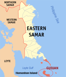
Homonhon Island ist eine den Philippinen zugehörige Insel. Sie wird politisch der Provinz Eastern Samar zugeordnet und gehört der eigenständig verwalteten Gemeinde Guiuan an. Die Insel markiert den östlichen Rand des Golfes von Leyte. Sie befindet sich westlich der Insel Leyte und liegt unterhalb des südlichen Ausläufers der Insel Samar. Sie hat eine Ausdehnung von 20 km.

Geschichte

Nach der Überquerung des Pazifiks passierten die drei Schiffe, die von Ferdinand Magellans Flotte übrig geblieben waren, die Inseln der Marianen[1] und erreichten am 16. März 1521 die Insel Humunu (früher Name der Insel Homonhon). Hier ging man an Land, um sich mit weiteren Vorräten einzudecken.[2] Kurz darauf wurde die Flotte von Booten des einheimischen Rajah Calambus entdeckt, der über die benachbarte Insel Limasawa herrschte. Die Sprache der Einheimischen war Magellans malaiischem Sklaven und Dolmetscher Enrique Melaka bekannt, der so zum ersten Menschen wurde, der nach einer Reise um die Erde seine Heimatregion wieder erreichte. Mittels des Dolmetschers Enrique gelang es Magellan, mit dem Herrscher von Limasawa in Verbindung zu treten und mit ihm Geschenke auszutauschen.[3]

Der Tag ihrer Landung war ein Sonntag während des Festes zu Ehren des heiligen Lazarus und markiert heute die Ankunft des christlichen Glaubens auf den Philippinen.

Magellan selbst gab der Insel den Namen „Homonhon Island“, der „Insel der Wasserstelle voll guter Zeichen“ bedeutet.

Fußnoten

  1. W.D. Brownlee (Master Mariner), 1974. The First Ships Around the World ISBN 0-8225-1204-1, S.44.
  2. Richard Humble, The Voyage of Magellan, Franklin Watts [1988] ISBN 0-531-10638-1 S.20.
  3. Laurence Bergreen, Over the Edge of the World : Magellan's Terrifying Circumnavigation of the Globe HarperCollins Publishers [2003] ISBN 0-06-621173-5

Wikimedia Foundation.

Игры ⚽ Нужен реферат?

Schlagen Sie auch in anderen Wörterbüchern nach:

  • Homonhon — Island is an island in the province of Eastern Samar, Philippines, on the west side of Leyte Gulf. It is about 20 km long.HistoryDuring the first circumnavigation of the globe, Ferdinand Magellan s three surviving vessels passed the Marianas, but …   Wikipedia

  • Homonhon — Homonhọn,   Insel der Philippinen, südlich von Samar, 104 km2, 23 000 Einwohner. Hier betrat F. de Magalhães am 17. 3. 1521 erstmals philippinischen Boden …   Universal-Lexikon

  • PH-EAS — Lage der Provinz Eastern Samar Die Provinz Eastern Samar liegt im Osten der Insel Samar auf den Philippinen und wird politisch dem Bezirk Eastern Visayas (Region VIII) zugeordnet. Der Hauptstadt der Provinzregierung, Borongan City, befindet sich… …   Deutsch Wikipedia

  • Eastern Samar — Lage der Provinz Eastern Samar Die Provinz Eastern Samar liegt im Osten der Insel Samar auf den Philippinen und wird politisch dem Bezirk Eastern Visayas (Region VIII) zugeordnet. Der Hauptstadt der Provinzregierung, Borongan, befindet sich im… …   Deutsch Wikipedia

  • Mazaua — is the name of a Philippine island port where Ferdinand Magellan and his Armada de Molucca fleet of three naos anchored from March 28 to April 4, 1521. At present, historians and scientists are still searching for the exact location of the said… …   Wikipedia

  • PH-08 — Karte des Bezirks Eastern Visayas Eastern Visayas (Tagalog: Silangang Kabisayaan) ist, neben dem Bezirk MIMAROPA, einer von zwei Regierungsbezirk der Philippinen, die keine Festlandgrenze zu einem anderen Bezirk besitzen. Der Bezirk umfasst die… …   Deutsch Wikipedia

  • Andrés de San Martín — was the chief pilot cosmographer of the Armada de Molucca , the fleet commanded by Ferdinand Magellan.His nationality has been variously identified as Portuguese or French. Antonio Pigafetta wrote he was from Seville, and there s every reason to… …   Wikipedia

  • History of the Philippines — The History of the Philippines is believed to have begun with the arrival of the first humans via land bridges at least 30,000 years ago.Harvnb|Dolan|1991 3] The first recorded visit from the West is the arrival of Ferdinand Magellan on Homonhon… …   Wikipedia

  • Guiuan, Eastern Samar — Guiuan is a 3rd class municipality in the province of Eastern Samar, Philippines. As of year 2004, it has a population of 43,647 people in 7,618 households.Guiuan is a significant part of the Philippine history. In the 16th century, when… …   Wikipedia

  • Suluan Island — is a small island in the Philippines, in the province of Eastern Samar. It lies east of Leyte Gulf, near Homonhon Island and Calicoan Island.It was the first ever landing place of Ferdinand Magellan s Armada after their 98 days Pacific crossing… …   Wikipedia

Share the article and excerpts

Direct link
Do a right-click on the link above
and select “Copy Link”