Holy Loch

Holy Loch
55.987-4.933
Holy Loch (Schottland)
Holy Loch
Holy Loch
Firth of Clyde mit dem Holy Loch (etwa Mitte, oberhalb von Dunoon
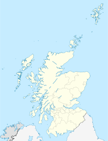
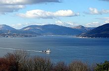
Holy Loch von Gourock aus gesehen, über den Firth of Clyde hinweg

Holy Loch (schottisch-gälisch An Loch Sianta/Seunta) ist ein Meeresarm und ein Ausläufer des Firth of Clyde in Argyll and Bute, Schottland.

Holy Loch öffnet sich an seinem Ostende zum Firth of Clyde, ist eine Meile breit und – je nach Tidenstand – zwei bis drei Meilen lang. Südlich des Meeresarms liegt auf der Cowal-Halbinsel die Stadt Dunoon, von dort folgen entlang des Südufers die Ortschaften Kirn, Hunter’s Quay, Ardnadam und Sandbank. Die Landschaft am Ende des Lochs ist unbesiedelt, während am Nordufer Kilmun und Strone folgen. Ein Teil der Orte ist durch Fähren untereinander und mit Gourock verbunden. Über Land ist die Gegend durch eine Straße mit Oban verbunden.

Während des Zweiten Weltkriegs diente Dunoon bzw. Holy Loch als U-Boot-Basis der Royal Navy und wurde intensiv für Übungen und Erprobungen genutzt. Auf dem Friedhof von Dunoon erinnern die Gräber der Besatzung des bei einem Unfall gesunkenen und später gehobenen Bootes HMS Untamed an diese Zeit. Zwischen 1960 und 1992 nutzte die US Navy Holy Loch als Standort für Atom-U-Boote, gegen deren Präsenz es immer wieder Demonstrationen gegeben hat.

Der Name wird darauf zurückgeführt, dass hier angeblich im 6. Jahrhundert St. Munn an Land gegangen ist, nachdem er Irland verlassen hatte.

Weblinks


Wikimedia Foundation.

Игры ⚽ Поможем решить контрольную работу

Schlagen Sie auch in anderen Wörterbüchern nach:

  • Holy Loch — a narrow area of the Atlantic Ocean reaching into the land on the west coast of Scotland, northwest of Glasgow. The US Navy formerly had a base there for its nuclear submarines …   Dictionary of contemporary English

  • Holy Loch — The Holy Loch (Scottish Gaelic An Loch Sianta/Seunta ) is a sea loch in Argyll and Bute, Scotland. Open to the Firth of Clyde at its eastern end, the loch is approximately one mile wide and between two and three miles (5 km) long, varying with… …   Wikipedia

  • Holy Loch — 55° 59′ 13″ N 4° 55′ 59″ W / 55.987, 4.933 …   Wikipédia en Français

  • Holy Loch — geographical name inlet of Firth of Clyde W Scotland on NW shore of the firth opposite mouth of the Clyde …   New Collegiate Dictionary

  • Loch Eck — von Norden Geographische Lage Loch Lomond and the Trossachs National Park, Argyll and Bute, Schottland …   Deutsch Wikipedia

  • Loch Lomond and the Trossachs National Park — Infobox protected area | name = Loch Lomond and The Trossachs National Park iucn category = II caption = Looking eastwards along Loch Katrine in the Loch Lomond and the Trossachs National Park locator x = locator y = location = Scotland, Argyll… …   Wikipedia

  • Loch Maree — Infobox lake lake name = Loch Maree image lake = Loch Maree.jpg caption lake = View of the islands image bathymetry = caption bathymetry = location = Northwest Highlands, Scotland coords = coord|57|41|23|N|5|27|27|W|region:GB… …   Wikipedia

  • Liste schottischer Lochs — Loch ist das schottisch gälische Wort für einen See oder eine Meeresbucht, einen Fjord (englisch Firth). Das Wort, lɔx, «loch» mit kehligem «ch» ausgesprochen, ist verwandt mit dem altirischen Lough, rekonstruierte indogermanische Wurzel… …   Deutsch Wikipedia

  • Dunoon — This article is about the town. For the small town, see Dunoon, New South Wales. Coordinates: 55°56′48″N 4°55′23″W / 55.946730°N 4.923000°W / …   Wikipedia

  • USS Theodore Roosevelt (SSBN-600) — USS Theodore Roosevelt (SSBN 600), a George Washington class submarine, was the second ship of the United States Navy to be named for President Theodore Roosevelt. Initially unnamed and assign hull classification symbol SSGN 600, her keel was… …   Wikipedia

Share the article and excerpts

Direct link
Do a right-click on the link above
and select “Copy Link”