- Holmes County (Ohio)
-
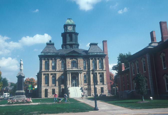
Verwaltung US-Bundesstaat: Ohio Verwaltungssitz: Millersburg Adresse des
Verwaltungssitzes:Old Jail Office Building
2 Court Street
Millersburg, OH 44654-2001Gründung: 20. Januar 1824 Gebildet aus: Coshocton County
Tuscarawas County
Wayne CountyVorwahl: 001 330 Demographie Einwohner: 41.369 (2007) Bevölkerungsdichte: 37,8 Einwohner/km² Geographie Fläche gesamt: 1.098 km² Wasserfläche: 3 km² Karte 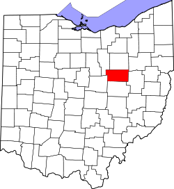
Website: www.holmescounty.com/gov Holmes County[2] ist ein County im Bundesstaat Ohio der Vereinigten Staaten von Amerika. Der Verwaltungssitz (County Seat) ist Millersburg. Holmes County hat die weltweit höchste Konzentration von Siedlungen der Amischen.
Inhaltsverzeichnis
Geografie
Das County liegt im mittleren Nordosten von Ohio und hat eine Fläche von 1098 Quadratkilometern, wovon 3 Quadratkilometer Wasserfläche sind. Es grenzt im Uhrzeigersinn an folgende Countys: Wayne County, Stark County, Tuscarawas County, Coshocton County, Knox County und Ashland County.
Geschichte
Holmes County wurde am 20. Januar 1824 aus Teilen des Coshocton-, Tuscarawas- und Wayne County gebildet. Benannt wurde es nach Abdrew Holmes, einem Offizier im Britisch-Amerikanischen Krieg.
Demografische Daten
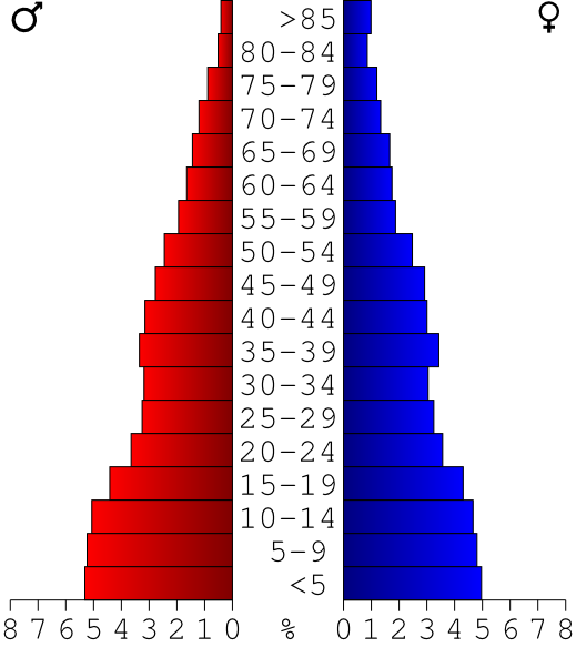
Historische Einwohnerzahlen Census Einwohner ± in % 1830 9135 — 1840 18.088 100 % 1850 20.452 10 % 1860 20.589 0,7 % 1870 18.177 -10 % 1880 20.776 10 % 1890 21.139 2 % 1900 19.511 -8 % 1910 17.909 -8 % 1920 16.965 -5 % 1930 16.726 -1 % 1940 17.876 7 % 1950 18.760 5 % 1960 21.591 20 % 1970 23.024 7 % 1980 29.416 30 % 1990 32.849 10 % 2000 38.943 20 % Vor 1900[3] 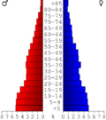 Alterspyramide des Holmes Countys (Stand: 2000)
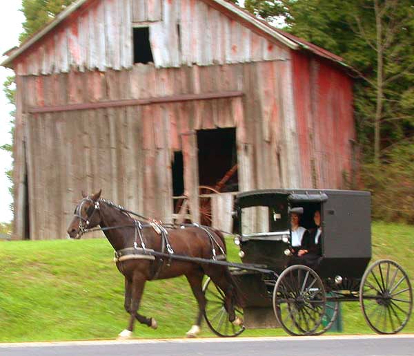
 Ein Amisch-Paar in einem Pferdewagen im Holmes County
Nach der Volkszählung im Jahr 2000 lebten im Holmes County 38.943 Menschen in 11.337 Haushalten und 9.194 Familien. Die Bevölkerungsdichte betrug 36 Einwohner pro Quadratkilometer. Ethnisch betrachtet setzte sich die Bevölkerung zusammen aus 99,03 Prozent Weißen, 0,33 Prozent Afroamerikanern, 0,06 Prozent amerikanischen Ureinwohnern, 0,06 Prozent Asiaten, 0,01 Prozent Bewohnern aus dem pazifischen Inselraum und 0,13 Prozent aus anderen ethnischen Gruppen; 0,40 Prozent stammten von zwei oder mehr Ethnien ab. 0,75 Prozent der Bevölkerung waren spanischer oder lateinamerikanischer Abstammung.
Von den 11.337 Haushalten hatten 44,3 Prozent Kinder und Jugendliche unter 18 Jahre, die bei ihnen lebten. 71,5 Prozent waren verheiratete, zusammenlebende Paare, 6,5 Prozent waren allein erziehende Mütter, 18,9 Prozent waren keine Familien, 16,1 Prozent waren Singlehaushalte und in 6,9 Prozent lebten Menschen im Alter von 65 Jahren oder darüber. Die Durchschnittshaushaltsgröße betrug 3,35 und die durchschnittliche Familiengröße lag bei 3,82 Personen.
Auf das gesamte County bezogen setzte sich die Bevölkerung zusammen aus 35,6 Prozent Einwohnern unter 18 Jahren, 10,4 Prozent zwischen 18 und 24 Jahren, 25,7 Prozent zwischen 25 und 44 Jahren, 17,8 Prozent zwischen 45 und 64 Jahren und 10,5 Prozent waren 65 Jahre alt oder darüber. Das Durchschnittsalter betrug 28 Jahre. Auf 100 weibliche Personen kamen 99,6 männliche Personen. Auf 100 Frauen im Alter von 18 Jahren oder darüber kamen statistisch 95,5 Männer.
Das jährliche Durchschnittseinkommen eines Haushalts betrug 36.944 USD, das Durchschnittseinkommen der Familien betrug 40.230 USD. Männer hatten ein Durchschnittseinkommen von 28.490 USD, Frauen 20.602 USD. Das Prokopfeinkommen betrug 14.197 USD. 10,5 Prozent der Familien und 12,9 Prozent der Bevölkerung lebten unterhalb der Armutsgrenze. Davon waren 17,4 Prozent Kinder oder Jugendliche unter 18 Jahre und 13,3 Prozent waren Menschen über 65 Jahre. [6]
Ortschaften
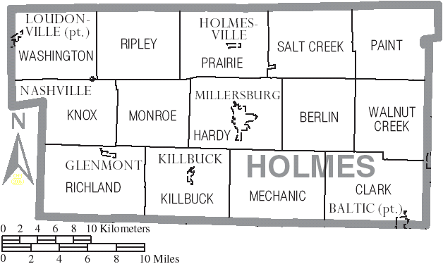
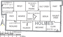 Verwaltungsgliederung des Holmes Countys
Villages
- Baltic
- Glenmont
- Holmesville
- Killbuck
- Loudonville
- Millersburg
- Nashville
Townships
- Berlin
- Clark
- Hardy
- Killbuck
- Knox
- Mechanic
- Monroe
- Paint
- Prairie
- Richland
- Ripley
- Salt Creek
- Walnut Creek
- Washington
Unincorporated communitys
- Berlin
- Big Prairie
- Charm
- Lakeville
- Mount Hope
- Walnut Creek
- Winesburg
Einzelnachweise
- ↑ Auszug aus dem National Register of Historic Places. Abgerufen am 13. März 2011
- ↑ Holmes County im Geographic Names Information System des United States Geological Survey. Abgerufen am 22. Februar 2011
- ↑ U.S. Census Bureau _ Census of Population and Housing. Abgerufen am 17. Februar 2011
- ↑ Auszug aus Census.gov. Abgerufen am 21. Februar 2011
- ↑ Auszug aus factfinder.census.gov Abgerufen am 21. Februar 2011
- ↑ Holmes County, Ohio, Datenblatt mit den Ergebnissen der Volkszählung im Jahre 2000 bei factfinder.census.gov.

Liste der Countys in Ohio
Adams | Allen | Ashland | Ashtabula | Athens | Auglaize | Belmont | Brown | Butler | Carroll | Champaign | Clark | Clermont | Clinton | Columbiana | Coshocton | Crawford | Cuyahoga | Darke | Defiance | Delaware | Erie | Fairfield | Fayette | Franklin | Fulton | Gallia | Geauga | Greene | Guernsey | Hamilton | Hancock | Hardin | Harrison | Henry | Highland | Hocking | Holmes | Huron | Jackson | Jefferson | Knox | Lake | Lawrence | Licking | Logan | Lorain | Lucas | Madison | Mahoning | Marion | Medina | Meigs | Mercer | Miami | Monroe | Montgomery | Morgan | Morrow | Muskingum | Noble | Ottawa | Paulding | Perry | Pickaway | Pike | Portage | Preble | Putnam | Richland | Ross | Sandusky | Scioto | Seneca | Shelby | Stark | Summit | Trumbull | Tuscarawas | Union | Van Wert | Vinton | Warren | Washington | Wayne | Williams | Wood | Wyandot
Wikimedia Foundation.
Schlagen Sie auch in anderen Wörterbüchern nach:
Holmes County, Ohio — Infobox U.S. County county = Holmes County state = Ohio founded = January 20 1824cite web|url = http://www.odod.state.oh.us/research/FILES/S0/Holmes.pdf |title = Ohio County Profiles: Holmes County |accessdate = 2007 04 28 |publisher = Ohio… … Wikipedia
National Register of Historic Places listings in Holmes County, Ohio — Location of Holmes County in Ohio This is a list of the National Register of Historic Places listings in Holmes County, Ohio. This is intended to be a complete list of the properties and districts on the National Register of Historic Places in… … Wikipedia
Clark Township, Holmes County, Ohio — Township Municipalities and townships of Holmes Co … Wikipedia
Mechanic Township, Holmes County, Ohio — Mechanic Township, Ohio Township Municipalities and townships of Holmes County … Wikipedia
Monroe Township, Holmes County, Ohio — Monroe Township, Ohio Township Municipalities and townships of Holmes County … Wikipedia
Paint Township, Holmes County, Ohio — Infobox Settlement official name = Paint Township, Holmes County, Ohio settlement type = Township nickname = motto = imagesize = image caption = image mapsize = 250px map caption = Municipalities and townships of Holmes County. mapsize1 = map… … Wikipedia
Prairie Township, Holmes County, Ohio — Infobox Settlement official name = Prairie Township, Holmes County, Ohio settlement type = Township nickname = motto = imagesize = image caption = image mapsize = 250px map caption = Municipalities and townships of Holmes County. mapsize1 = map… … Wikipedia
Washington Township, Holmes County, Ohio — Infobox Settlement official name = Washington Township, Holmes County, Ohio settlement type = Township nickname = motto = imagesize = image caption = image mapsize = 250px map caption = Municipalities and townships of Holmes County. mapsize1 =… … Wikipedia
Salt Creek Township, Holmes County, Ohio — Infobox Settlement official name = Salt Creek Township, Holmes County, Ohio settlement type = Township nickname = motto = imagesize = image caption = image mapsize = 250px map caption = Municipalities and townships of Holmes County. mapsize1 =… … Wikipedia
Walnut Creek Township, Holmes County, Ohio — Infobox Settlement official name = Walnut Creek Township, Holmes County, Ohio settlement type = Township nickname = motto = imagesize = image caption = image mapsize = 250px map caption = Municipalities and townships of Holmes County. mapsize1 =… … Wikipedia
Holmes County (Ohio)

18+
© Academic, 2000-2024
- Kontaktieren Sie uns: Unterstützung, Werbung
Wörterbücher Export, schritte mit PHP, Joomla, Drupal, WordPress, MODx.