- Hokota
-
Hokota-shi
鉾田市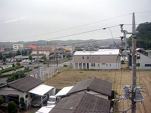
Geographische Lage in Japan 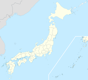

Region: Kantō Präfektur: Ibaraki Koordinaten: 36° 9′ N, 140° 31′ O36.15140.51666666667Koordinaten: 36° 9′ 0″ N, 140° 31′ 0″ O Basisdaten Fläche: 203,90 km² Einwohner: 49.202
(1. Juli 2011)Bevölkerungsdichte: 241 Einwohner je km² Gemeindeschlüssel: 08234-1 Rathaus Adresse: Hokota City Hall
1444-1, Hokota
Hokota-shi
Ibaraki 311-1592Webadresse: http://www.city.hokota.lg.jp Lage Hokotas in der Präfektur Ibaraki 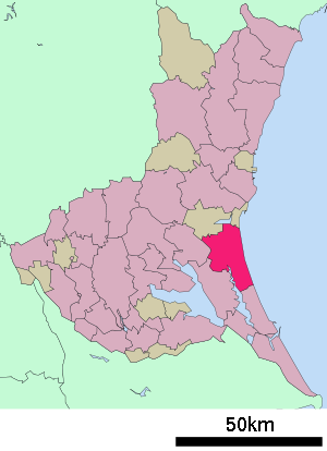
Hokota (jap. 鉾田市, -shi) ist eine Stadt in Japan in der Präfektur Ibaraki.
Inhaltsverzeichnis
Geographie
Hokota liegt südlich von Mito und nördlich von Kashima am Pazifischen Ozean.
Geschichte
Die Stadt Hokota wurde am 11. Oktober 2005 aus den ehemaligen Gemeinden Asahi, Hokota und Taiyo gegründet.
Verkehr
- Zug:
- Kashima-Rinkai-Eisenbahn
- Straße:
- Nationalstraße 51,124,354
Angrenzende Städte und Gemeinden
Weblinks
-
 Commons: Hokota – Sammlung von Bildern, Videos und Audiodateien
 - Offizielle Website (japanisch)
 Gemeinden und Landkreise in der Präfektur Ibaraki
Kreisfreie Städte (shi): Bandō | Chikusei | Hitachi | Hitachinaka | Hitachi-Ōmiya | Hitachi-Ōta | Hokota | Inashiki | Ishioka | Itako | Jōsō | Kamisu | Kasama | Kashima | Kasumigaura | Kitaibaraki | Koga | Moriya | Mito (Verwaltungssitz) | Naka | Namegata | Omitama | Ryūgasaki | Sakuragawa | Shimotsuma | Takahagi | Toride | Tsuchiura | Tsukuba | Tsukubamirai | Ushiku | Yūki
Higashiibaraki-gun: Ibaraki | Oarai | Shirosato | Inashiki-gun: Ami | Kawachi | Miho | Kitasouma-gun: Tone | Kuji-gun: Daigo | Naka-gun: Tōkai | Sashima-gun: Goka | Sakai | Yūki-gun: Yachiyo
Wikimedia Foundation.
Schlagen Sie auch in anderen Wörterbüchern nach:
Hokota, Ibaraki — nihongo|Hokota|鉾田市|Hokota shi is a city located in Ibaraki Prefecture, Japan.Hokota city was established in October 11, 2005, by the merger of Hokota town, Asahi village and Taiyō village from Kashima District.As of September 1, 2005, the city… … Wikipedia
Hokota-shi — Admin ASC 2 Code Orig. name Hokota shi Country and Admin Code JP.14.7452799 JP … World countries Adminstrative division ASC I-II
Asahi, Ibaraki — This article is about the village in Ibaraki Prefecture, Japan. Asahi is a common name in Japan, for other uses see Asahi. Map of Asahi, Ibaraki Asahi (旭村; mura) was a village located in Kashima District, Ibaraki, Japan. On October 11, 2005 Asahi … Wikipedia
Kashima District, Ibaraki — Kashima (鹿島郡; gun) is a district located in Ibaraki, Japan.As of 2003, the district has an estimated population of 141,935 and a density of 404.21 persons per km². The total area is 351.14 km².Mergers* On August 1, 2005, the municipalities of… … Wikipedia
Kashima Railway Line — The nihongo|Kashima Railway Line|鹿島鉄道線|Kashima Tetsudōsen was the sole line operated by the Kashima Railway Company in Ibaraki Prefecture, Japan. It operated between Ishioka Station and Hokota Station. It closed on 1 April 2007.Data*Length: 27.2… … Wikipedia
Mito Station (Ibaraki) — Mito Station 水戸駅 Mito Station north entrance, January 2007 Location P … Wikipedia
Kawasaki Ki-48 — infobox Aircraft name = Ki 48 type = Light bomber manufacturer = Kawasaki caption = Kawasaki Ki 48 designer = Takeo Doi first flight = introduction = 1940 retired = status = primary user = Imperial Japanese Army Air Force more users = produced =… … Wikipedia
List of dissolved districts of Japan — A district of Japan is dissolved when all towns or villages in the district become cities or are merged into the city. The following is a list of dissolved districts of Japan.The date shown is the day the district was dissolved i.e. the district… … Wikipedia
List of mergers in Ibaraki Prefecture — The following is a list of mergers that occurred in the 2000s in Ibaraki Prefecture, Japan.(as of December 8, 2007)Mergers from April 1, 1999 to March 31, 2000Mergers from April 1, 2000 to March 31, 2001Mergers from April 1, 2001 to March 31,… … Wikipedia
Hitachi-Omiya — 常陸大宮市 Hitachi Ōmiya shi … Deutsch Wikipedia
- Zug:
Hokota


18+
© Academic, 2000-2024
- Kontaktieren Sie uns: Unterstützung, Werbung
Wörterbücher Export, schritte mit PHP, Joomla, Drupal, WordPress, MODx.