Hokianga Harbour

Hokianga Harbour
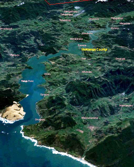
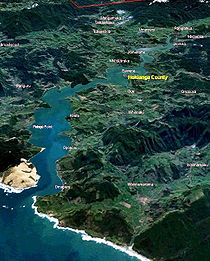
NASA World Wind Satelliten-Aufnahme des Hokianga Harbour

Der Hokianga Harbour, der auch als Hokianga River bezeichnet wird, ist ein Naturhafen an der Westküste der nördlichen neuseeländischen Nordinsel. Der etwas weiter gefasste Begriff The Hokianga schließt neben der eigentlichen Wasserfläche auch noch das umliegende Gebiet mit ein.

Die ersten Bewohner des Pazifikstaates, die Māori, gaben dieser von Wasser umspülten Tälerlandschaft gleich drei Namen: Zum einen „Te Kohanga o Te Tai Tokerau“ (Maorisch für Das Nest der nördlichen Menschen), des Weiteren „Te Puna o Te Ao Marama“, was so viel wie Die Quelle des Mondlichts bedeutet sowie zu guter Letzt das schlussendlich namensgebende „Te Hokianga-nui-a-Kupe“, das für den Ort der großartigen Rückkehr des Kupe steht.

Geographie

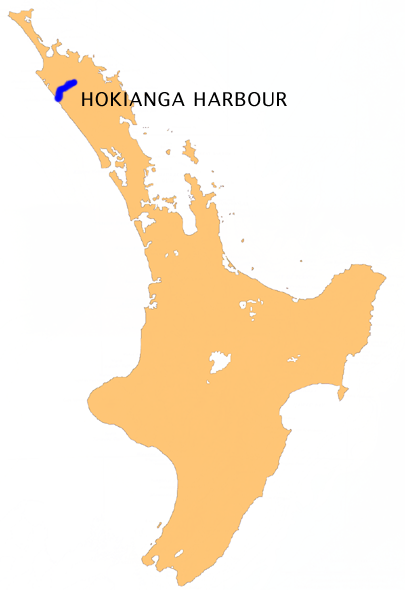
Die Lage des Hokianga Harbour auf der neuseeländischen Nordinsel

Der Hafen von Hokianga befindet sich im nördlichsten Landesteil im Far-North-Distrikt in der Region Northland etwa 85 Kilometer nordwestlich von Whangarei und 25 Kilometer westlich von Kaikohe. Von der Tasmanischen See im Westen aus erstreckt sich der Ästuar auf eine Länge von 30 Kilometern landeinwärts.

Vor ungefähr 12.000 Jahren stellte der Hokianga River ein Flusstal dar, das von Büschen und Bäumen gesäumt wurde. Mit dem Ausklingen der letzten Eiszeit und dem damit verbundenen dramatischen Anstieg des Meeresspiegels wurde das Tal langsam überflutet und das Süßwasser durch das noch heute vorherrschende Salzwasser ersetzt, an dessen Ufer sich zahlreiche Ankerplätze finden. Die Umgebung des überfluteten Ästuars lässt sich geographisch in drei Bereiche aufgliedern: Im Süden schließen sich die Ortschaften Waimamaku, Omapere, Opononi, Pakanae, Koutu, Whirinaki, Rawene, Waima und Taheke an, während die Menschen im Norden in Siedlungen wie Broadwood, Pawarenga, Panguru, Mitimiti und Rangi Point leben. Abschließend sind noch die Orte Horeke, Kohukohu und Mangamuka zu nennen, die im Osten an die Wasserfläche anschließen.

-35.525173.370833333337Koordinaten: 35° 32′ S, 173° 22′ O


Wikimedia Foundation.

Игры ⚽ Нужен реферат?

Schlagen Sie auch in anderen Wörterbüchern nach:

  • Hokianga — Image of the Hokianga generated by NASA s World Wind program Hokianga (or the Hokianga) is an area surrounding the Hokianga Harbour, also known as The Hokianga River, a long estuarine drowned valley on the west coast in the north of the North… …   Wikipedia

  • Hokianga — NASA World Wind Satelliten Aufnahme des Hokianga Harbour Der Hokianga Harbour, der auch als Hokianga River bezeichnet wird, ist ein Naturhafen an der Westküste der nördlichen neuseeländischen Nordinsel. Der etwas weiter gefasste Begriff The… …   Deutsch Wikipedia

  • Copthorne Hotel & Resort Hokianga (Hokianga) — Copthorne Hotel & Resort Hokianga country: New Zealand, city: Hokianga (Omapere) Copthorne Hotel & Resort Hokianga Situated at Omapere, the Copthorne Hotel and Resort Hokianga is a perfect place to discover the rich history and beauty of the city …   International hotels

  • Whangape Harbour — Location map North Island label=Whangape Harbour lat dir=S | lat deg=35 | lat min=21 lon dir=E | lon deg=173 | lon min=14 position=right width= 150 float=right caption=Whangape Harbour is a harbour on the west coast of Northland, New Zealand.… …   Wikipedia

  • Otago Harbour — Location of Otago Harbour in Southern Island. Otago Harbour is the natural harbour of Dunedin, New Zealand, consisting of a long, much indented stretch of generally navigable water separating the Otago Peninsula from the mainland. They join at… …   Wikipedia

  • Whangaroa Harbour — Location map North Island label=Whangaroa Harbour lat dir=S | lat deg=35 | lat min=3 lon dir=E | lon deg=173 | lon min=44 position=right width= 150 float=right caption=Whangaroa Harbour Pronunciation needed is an inlet on the northern coast of… …   Wikipedia

  • Whangaroa Harbour — …   Deutsch Wikipedia

  • Kupe — of some tribes, Kupe was involved in the Polynesian discovery of New Zealand.ContentionThere is contention concerning the status of Kupe. The contention turns on the authenticity of later versions of the legends, the so called orthodox versions… …   Wikipedia

  • Rawene — Infobox Settlement name = Rawene population total = 438 population as of = 2006 subdivision type = Country subdivision name = New Zealand subdivision type1= Region subdivision name1= Northland Region subdivision type2= District subdivision name2 …   Wikipedia

  • Mangamuka — Mangamuka …   Wikipedia

Share the article and excerpts

Direct link
Do a right-click on the link above
and select “Copy Link”