- Hertsmere
-
Borough of Hertsmere 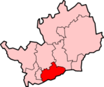
Lage in HertfordshireStatus Borough Region East of England Verw.grafschaft Hertfordshire Verwaltungssitz Borehamwood Fläche 101,16 km² (243.) Einwohner 97.000 (234.) ONS-Code 26UE Website www.hertsmere.gov.uk Hertsmere ist ein Verwaltungsbezirk mit dem Status eines Borough in der Grafschaft Hertfordshire in England. Verwaltungssitz ist Borehamwood.
Der Bezirk wurde am 1. April 1974 gebildet und entstand aus der Fusion der Urban Districts Bushey und Potters Bar, des Rural District Elstree und eines Teils des Rural District Watford.
Der Name Hertsmere ist eine Kombination aus dem Namen der Grafschaft und dem Wort "mere", das im Altenglischen für "Grenze" steht. Dies ist insofern einleuchtend, als Hertsmere im Süden an Greater London grenzt. Nach seiner Gründung war Hertsmere zunächst ein District, wurde aber 1977 durch königliches Dekret zu einem Borough.
Orte im Borough
- Aldenham
- Borehamwood
- Bushey
- Elstree
- Potters Bar
- Ridge
- Shenley
Broxbourne | Dacorum | East Hertfordshire | Hertsmere | North Hertfordshire | St Albans | Stevenage | Three Rivers | Watford | Welwyn Hatfield
Wikimedia Foundation.
Schlagen Sie auch in anderen Wörterbüchern nach:
Hertsmere — is a local government district and borough in Hertfordshire, England. Its council is based in Borehamwood. Other towns in the borough include Bushey, Elstree, Radlett and Potters Bar.HistoryThe district was formed on 1 April 1974, under the Local … Wikipedia
Hertsmere — 51° 40′ N 0° 16′ W / 51.66, 0.27 … Wikipédia en Français
Hertsmere — ▪ district, England, United Kingdom borough (district), administrative county of Hertfordshire, England. Most of the borough belongs to the historic county of Hertfordshire, but the eastern part of the borough, including Potters Bar, lies… … Universalium
Hertsmere Borough Council — is the local authority for the Hertsmere non metropolitan district of England, the United Kingdom. Hertsmere is located in the south of Hertfordshire, in the East of England region. The Council itself is based in Borehamwood, the largest… … Wikipedia
Hertsmere (UK Parliament constituency) — UK constituency infobox Name = Hertsmere Map1 = Hertsmere Map2 = Hertfordshire Type = County Year = 1983 Entity = Hertfordshire County = Hertfordshire EP = East of England MP = James Clappison Party = ConservativeHertsmere is a constituency… … Wikipedia
Potters Bar — infobox UK place country = England official name= Potters Bar map type= Greater London latitude= 51.698 longitude= 0.183 population= 21,618 [http://www.hertsdirect.org/infobase/docs/pdfstore/tabKS01sett.pdf Herfordshire County Council] Office for … Wikipedia
Radlett — infobox UK place country = England official name= Radlett latitude= 51.682 longitude= 0.314 MapY= 203 population= 8,034 (2001 census) shire district= Hertsmere shire county = Hertfordshire region= East of Englandconstituency westminster=… … Wikipedia
Parliamentary constituencies in Hertfordshire — The county of Hertfordshire in relation to England The county of Hertfordshire in England is divided into eleven Parliamentary constituencies. Each of the eleven elects a Member of Parliament (MP) to represent it at the United K … Wikipedia
Watford — This article is about the town in Hertfordshire. For other uses, see Watford (disambiguation). For the council, see Watford Borough Council. Watford Town and Borough Borough of Watford … Wikipedia
James Clappison — Infobox MP honorific prefix = name = James Clappison honorific suffix = caption = constituency MP = Hertsmere parliament = term start = 9 April 1992 term end = majority = 11,093 (26.1%) predecessor = Cecil Parkinson successor = birth date = Birth … Wikipedia
Hertsmere

18+
© Academic, 2000-2024
- Kontaktieren Sie uns: Unterstützung, Werbung
Wörterbücher Export, schritte mit PHP, Joomla, Drupal, WordPress, MODx.