- Hernando County
-
 Hernando County Courthouse
Verwaltung US-Bundesstaat: Florida Verwaltungssitz: Brooksville Adresse des
Verwaltungssitzes:Board of County Commissioners
20 North Main Street
Brooksville, Florida 34601Gründung: 27. Februar 1843 Gebildet aus: Alachua County Vorwahl: 001 352 Demographie Einwohner: 130.802 (2000) Bevölkerungsdichte: 105,6 Einwohner/km² Geographie Fläche gesamt: 1.526 km² Wasserfläche: 287 km² Karte 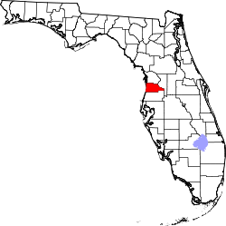
Website: www.co.hernando.fl.us Das Hernando County[1] ist ein County im Bundesstaat Florida der Vereinigten Staaten von Amerika. Der Verwaltungssitz (County Seat) ist Brooksville.
Inhaltsverzeichnis
Geschichte
Etwa um 1840 wurde das Fort DeSoto im Nordosten des heutigen Hernando County erbaut. Fort Desoto wurde ein kleiner Stützpunkt und Zwischenstation auf dem Weg nach Tampa. Das Damals wesentlich größere Hernando County wurde am 27. Februar 1843 aus Teilen des Alachua County gebildet, benannt nach Hernando de Soto. Vom 6. März 1844 bis zu 24. Dezember 1850 war es umbenannt in "Benton County". 1854 wurde die kleine Hafenstadt Bayport Sitz der Verwaltung. 1856 wurde die Stadt in Brooksville umbenannt. 1855 spendete der Gründer der Stadt, Joseph Hale, ein Stück Land für ein Bezirksgerichtsgebäude im Zentrum des heutigen Brooksville. Am 2. Januar 1887 wurde durch die Regierung von Florida das Hernando County in drei unabhängige Countys geteilt: In das Pasco County im Süden, das Citrus County im Norden und das Hernando County in der Mitte. Seitdem sind die Grenzen des Hernando County unverändert geblieben.
Geografie
Das County hat eine Fläche von 1.526 Quadratkilometern, wovon 287 Quadratkilometer Wasserfläche sind. Es grenzt im Uhrzeigersinn an folgende Countys: Citrus County, Sumter County, Pasco County.
Demografische Daten
Historische Einwohnerzahlen Census Einwohner ± in % 1850 926 — 1860 1200 30 % 1870 2938 100 % 1880 4248 40 % 1890 2476 -40 % 1900 3638 50 % 1910 4997 40 % 1920 4548 -9 % 1930 4948 9 % 1940 5641 10 % 1950 6693 20 % 1960 11.205 70 % 1970 17.004 50 % 1980 44.469 200 % 1990 101.115 100 % 2000 130.802 30 % Vor 1900[2] 1900–1990[3]
Nach der Volkszählung im Jahr 2000 lebten im Hernando County 130.802 Menschen in 55.425 Haushalten und 40.016 Familien. Die Bevölkerungsdichte betrug 106 Einwohner pro Quadratkilometer. Ethnisch betrachtet setzte sich die Bevölkerung zusammen aus 92,85 Prozent Weißen, 4,07 Prozent Afroamerikanern, 0,30 Prozent amerikanischen Ureinwohnern, 0,64 Prozent Asiaten, 0,02 Prozent Bewohnern aus dem pazifischen Inselraum und 0,98 Prozent aus anderen ethnischen Gruppen; 1,13 Prozent stammten von zwei oder mehr Ethnien ab. 5,04 Prozent der Gesamtbevölkerung waren spanischer oder lateinamerikanischer Abstammung.
 Alterspyramide des Hernando County
Von den 55.425 Haushalten hatten 21,8 Prozent Kinder und Jugendliche unter 19 Jahre, die bei ihnen lebten. 60,4 Prozent waren verheiratete, zusammenlebende Paare, 8,7 Prozent waren allein erziehende Mütter und 27,8 Prozent waren keine Familien. 23,3 Prozent waren Singlehaushalte und in 14,7 Prozent lebten Menschen im Alter von 65 Jahren oder darüber. Die Durchschnittshaushaltsgröße betrug 2,32 und die durchschnittliche Familiengröße betrug 2,70 Personen.
18,9 Prozent der Bevölkerung waren unter 18 Jahre alt, 5,4 Prozent zwischen 18 und 24, 20,4 Prozent zwischen 25 und 44, 24,4 Prozent zwischen 45 und 64 und 30,9 Prozent der Bevölkerung war 65 Jahre oder älter. Das Durchschnittsalter betrug 50 Jahre. Auf 100 weibliche Personen kamen statistisch 90,5 männliche Personen und auf 100 Frauen im Alter von 18 Jahren oder darüber kamen 87,5 Männer.
Das jährliche Durchschnittseinkommen eines Haushalts betrug 32.572 USD, das Durchschnittseinkommen der Familien 37.509 USD. Männer hatten ein Durchschnittseinkommen von 30.295 USD, Frauen 21.661 USD. Das Prokopfeinkommen betrug 18.321 USD. 7,1 Prozent der Familien und 10,3 Prozent der Bevölkerung lebten unterhalb der Armutsgrenze. [4]
Weiterführende Bildungseinrichtungen
- Pasco-Hernando Community College in Brooksville
- Pasco-Hernando Community College in Spring Hill
Die wichtigsten Städte
- Bayport
- Brookridge
- Brooksville
- Hernando Beach
- High Point
- Hill 'n Dale
- Istachatta
- Lake Lindsey
- Masaryktown
- Nobleton
- North Brooksville
- North Weeki Wachee
- Pine Island
- Ridge Manor
- South Brooksville
- Spring Hill
- Spring Lake
- Timber Pines
- Weeki Wachee Gardens
- Weeki Wachee
Einzelnachweise
- ↑ GNIS-ID: 295751. Abgerufen am 22. Februar 2011 (englisch).
- ↑ U.S. Census Bureau - Census of Population and Housing. Abgerufen am 15. März 2011
- ↑ Auszug aus Census.gov. Abgerufen am 14. Februar 2011
- ↑ Hernando County, Florida, Datenblatt mit den Ergebnissen der Volkszählung im Jahre 2000 bei factfinder.census.gov.
Weblinks
 Commons: Hernando County – Sammlung von Bildern, Videos und Audiodateien
- offizielle Webseite (Englisch)

Liste der Countys in Florida
Alachua | Baker | Bay | Bradford | Brevard | Broward | Calhoun | Charlotte | Citrus | Clay | Collier | Columbia | De Soto | Dixie | Duval | Escambia | Flagler | Franklin | Gadsden | Gilchrist | Glades | Gulf | Hamilton | Hardee | Hendry | Hernando | Highlands | Hillsborough | Holmes | Indian River | Jackson | Jefferson | Lafayette | Lake | Lee | Leon | Levy | Liberty | Madison | Manatee | Marion | Martin | Miami-Dade | Monroe | Nassau | Okaloosa | Okeechobee | Orange | Osceola | Palm Beach | Pasco | Pinellas | Polk | Putnam | Santa Rosa | Sarasota | Seminole | St. Johns | St. Lucie | Sumter | Suwannee | Taylor | Union | Volusia | Wakulla | Walton | Washington
Wikimedia Foundation.
Schlagen Sie auch in anderen Wörterbüchern nach:
Hernando County — Admin ASC 2 Code Orig. name Hernando County Country and Admin Code US.FL.053 US … World countries Adminstrative division ASC I-II
Hernando County, Florida — Seal … Wikipedia
Hernando County, Florida Sheriff's Office — Infobox Police Department name = Hernando County Sheriff s Office motto = established = jurisdiction = County sworn = non sworn = CSO = stations = jails = helicopters = policeboats = chief = sheriff = Richard B. Nugent commissioner = supervisor … Wikipedia
Hernando County Courthouse — Infobox Historic building name = Hernando County Courthouse caption = map type = latitude = longitude = location town = Brooksville, Florida location country = United States architect = William Augustus Edwards client = engineer = construction… … Wikipedia
Hernando County Airport — industrial park, prison, land rentals, and tree farming.cite web title = Hernando County Airport and Aviation Authority url = http://www.co.hernando.fl.us/Airport/index.htm] Army National GuardSince 2000, the Hernando County Airport has been home … Wikipedia
List of county roads in Hernando County, Florida — County road shields used in Florida Highway names County: County Road X (CR X) System links Florida State an … Wikipedia
National Register of Historic Places listings in Hernando County, Florida — Location of Hernando County in Florida This is a list of the National Register of Historic Places listings in Hernando County, Florida. This is intended to be a complete list of the properties and districts on the National Register of Historic… … Wikipedia
High Point, Hernando County, Florida — Infobox Settlement official name = High Point, Florida other name = native name = nickname = settlement type = CDP motto = imagesize = image caption = flag size = image seal size = image shield = shield size = image blank emblem = blank emblem… … Wikipedia
Hernando High School (Florida) — Hernando High School is a public high school located in Brooksville, Florida. It is part of the Hernando County School District. It has been in operation since 1889, which makes it one of the oldest, continuously operating public high schools in… … Wikipedia
Hernando de Soto (Entdecker) — Hernando de Soto (* 1496 oder 1500 in Barcarrota oder Jerez de los Caballeros, Extremadura; † 21. Mai 1542 wahrscheinlich am Mississippi River wenige Kilometer flussabwärts vom heutigen Memphis) war ein spanischer Seefahrer und Konquistador. Er… … Deutsch Wikipedia
Hernando County


18+
© Academic, 2000-2024
- Kontaktieren Sie uns: Unterstützung, Werbung
Wörterbücher Export, schritte mit PHP, Joomla, Drupal, WordPress, MODx.