Harden Shire

Harden Shire
Shire of Harden
Australia-Map-NSW-LGA-Harden.png
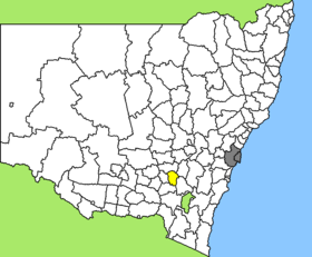
Lage des Harden Shire in New South Wales
Gliederung
Staat: Australien Australien
Bundesstaat: Flag of New South Wales.svg New South Wales
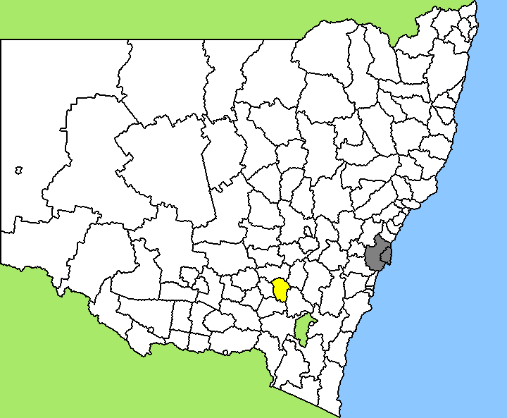
Verwaltungssitz: Harden
Daten und Zahlen
Fläche: 1.896 km²
Einwohner: 3.582 (2006) [1]
Bevölkerungsdichte: 1,9 Einwohner je km²
-34.55148.36666666667

Harden Shire ist ein lokales Verwaltungsgebiet (LGA) im australischen Bundesstaat New South Wales. Das Gebiet ist 1.896 km² groß und hat etwa 3.600 Einwohner.

Harden liegt in der Südostregion des Staates etwa 130 km nordöstlich der australischen Hauptstadt Canberra und 335 km südöstlich der Metropole Sydney. Das Gebiet umfasst 25 Ortsteile und Ortschaften: Aurville, Beggan Beggan, Berremangra, Bogolara, Boyeo, Cumbamurra, Cunningar, Currawong, Demondrille, Galong, Garangula, Harden, Kingsvale, McMahons Reef, Murrumburrah, Nannong, Nubba, Old Barwang, Prunevale, Redbridge, St Clements, Stanley Park und Teile von Jugiong, Wombat und Young. Der Sitz des Shire Councils befindet sich in Harden im Zentrum der LGA.

Verwaltung

Der Harden Shire Council hat sieben Mitglieder, die von den Bewohnern der LGA gewählt werden. Harden ist nicht in Bezirke untergliedert. Aus dem Kreis der Councillor rekrutiert sich auch der Mayor (Bürgermeister) des Councils.

Weblinks

Einzelnachweise

  1. Australian Bureau of Statistics (25. Oktober 2007): Harden (A) (Local Government Area) (Englisch). 2006 Census QuickStats. Abgerufen am 6. April 2010.

Wikimedia Foundation.

Игры ⚽ Поможем написать курсовую

Schlagen Sie auch in anderen Wörterbüchern nach:

  • Harden Shire Council — Infobox Australian Place | type = lga name = Harden Shire caption = Location in New South Wales state=New South Wales region=South West Slopes area=1869 cite web title=Harden Shire Council publisher = Department of Local Government url =… …   Wikipedia

  • Harden — ist der Familienname folgender Personen: Arthur Harden (1865–1940), britischer Chemiker und Nobelpreisträger Cecil M. Harden (1894–1984), US amerikanische Politikerin Ingo Harden (* 1928), deutscher Musikkritiker und Autor James Harden (* 1989),… …   Deutsch Wikipedia

  • Harden County — Map of all coordinates from Google Map of all coordinates from Bing Export all coordinates as KML …   Wikipedia

  • Harden, New South Wales — Infobox Australian Place | type = town name = Harden state = nsw caption = lga = Harden Shire postcode = 2587 est = pop = 1,996 (2006)Census 2006 AUS|id=UCL157400|name=Murrumburrah (Harden) (Urban Centre/Locality)|accessdate=2008 03 22|quick=on]… …   Wikipedia

  • Harden — /ˈhadn/ (say hahdn) noun a town and shire in south eastern NSW near Cootamundra; adjacent to Murrumburrah, its twin town …  

  • Wakool Shire — Shire of Wakool New South Wales Location in New South Wales Population: 4,427(2009) …   Wikipedia

  • Cootamundra Shire — New South Wales Location in New South Wales Population …   Wikipedia

  • Muswellbrook Shire — New South Wales Location in New South Wales Population …   Wikipedia

  • Conargo Shire — New South Wales Location in New South Wales Population: 1,700(2009) …   Wikipedia

  • Murray Shire — This article is about the Murray Shire in New South Wales. For the Western Australia shire, see Shire of Murray. Murray Shire New South Wales …   Wikipedia

Share the article and excerpts

Direct link
Do a right-click on the link above
and select “Copy Link”