- Hakarimata Range
-
Hakarimata Range 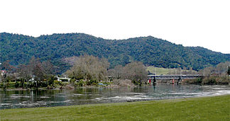
Hakarimata Range, im Vordergrund der Waikato River
Lage Region Waikato, Neuseeland Koordinaten 37° 44′ S, 175° 3′ O-37.734340111667175.04928588861Koordinaten: 37° 44′ S, 175° 3′ O Hakarimata Range ist eine Bezeichnung für die Hügel und Küstenzüge der neuseeländischen Region Waikato, die sich zwischen der Flutebene des Waikato River und der Tasmansee erstrecken.
Teile des Gebietes sind durch Landschaftsschutzgebiete bei den Orten Huntly und Ngaruawahia sowie den Pirongia Forest Park geschützt. Es gibt mehrere Wanderwege durch die Berge, die einen guten Ausblick auf die Waikato Plains darunter bieten.
Der State Highway 36 folgt annähernd der Ostseite des Gebirgszuges. Die Stadt Hamilton befindet sich etwa 20 km östlich.
Quellen
- New Zealand Travel Atlas, Wise Maps Auckland, Karte 13, ISBN 0-908794-47-9
Kategorien:- Waikato (Region)
- Gebirge in Neuseeland

Wikimedia Foundation.