- Hachinohe
-
Hachinohe-shi
八戸市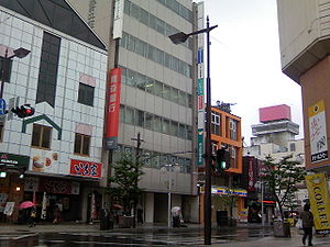
Geographische Lage in Japan 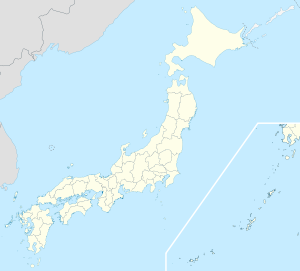

Region: Tōhoku Präfektur: Aomori Koordinaten: 40° 31′ N, 141° 29′ O40.512222222222141.48833333333Koordinaten: 40° 30′ 44″ N, 141° 29′ 18″ O Basisdaten Fläche: 305,19 km² Einwohner: 236.535
(1. Oktober 2011)Bevölkerungsdichte: 775 Einwohner je km² Gemeindeschlüssel: 02203-9 Symbole Flagge/Wappen: 
Baum: Japanische Eibe Blume: Garten-Chrysantheme Vogel: Japanmöwe Rathaus Adresse: Hachinohe City Hall
1-1-1, Uchimaru
Hachinohe-shi
Aomori 031-8686Webadresse: http://www.city.hachinohe.aomori.jp Lage Hachinohes in der Präfektur Aomori 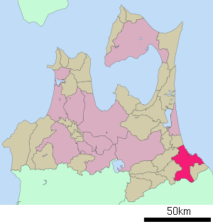
Hachinohe (jap. 八戸市, -shi) ist eine Hafenstadt in der Präfektur Aomori im Nordosten von Honshū, der Hauptinsel Japans. Die Stadt zählt über 243.000 Einwohner, neben der Fischerei spielt Textilindustrie und Holzverarbeitung eine wirtschaftliche Rolle.
Inhaltsverzeichnis
Geographie
Hachinohe liegt südöstlich von Aomori und nördlich von Morioka am Pazifischen Ozean.
Geschichte
Die Stadt besteht seit dem 1. Mai 1929.
Am 11. März 2011 war Hachinohe vom größten bisher in Japan registrierten Erdbeben, dem Tōhoku-Erdbeben und nachfolgendem Tsunami heimgesucht. Im Hafen Hachinohe entstand beträchtlicher Schaden, große und kleine Fischerboote wurden umgeworfen und fortgeschwemmt, die Straßen im Hafenviertel wurden überschwemmt. Der Hafen wurde vom ausgeflossenen Öl schwarz gefärbt, das Stadtbild veränderte sich. Die Evakuierung dauerte bis in den nächsten Tag. Ein Todesopfer wurde gemeldet, zwei weitere Personen gelten als vermisst, alle in den 60er Lebensjahren. 210 Gebäude wurden beschädigt und 915 weitere überschwemmt, 100 Autos fortgeschwemmt.[1].
Verkehr
- Zug
- Straße:
- Hachinohe-Autobahn
- Nationalstraße 45,104,340,454
Städtepartnerschaften
 Federal Way, seit 1993
Söhne und Töchter der Stadt
- Yūto Hara (* 1986), Eishockeyspieler
- Michio Hashimoto (* 1977), Eishockeyspieler
- Chiharu Ichō (* 1981), Ringerin
- Kaori Ichō (* 1984), Ringerin
- Tetsuo Miura (1931–2010), Schriftsteller
- Tadamori Ōshima (* 1946), Politiker
Einzelnachweise
- ↑ 大津波で3人死亡, Drei Tote in Aomori, Yomiuri Shimbun (japanisch)
Weblinks
 Commons: Hachinohe – Sammlung von Bildern, Videos und Audiodateien
 Gemeinden und Landkreise in der Präfektur Aomori
Kreisfreie Städte (shi): Aomori (Verwaltungssitz) | Goshogawara | Hachinohe | Hirakawa | Hirosaki | Kuroishi | Misawa | Mutsu | Towada | Tsugaru
Higashitsugaru-gun: Hiranai | Imabetsu | Sotogahama | Yomogita | Kamikita-gun: Noheji | Oirase | Rokkasho | Rokunohe | Shichinohe | Tōhoku | Yokohama | Kitatsugaru-gun: Itayanagi | Nakadomari | Tsuruta | Minamitsugaru-gun: Fujisaki | Inakadate | Ōwani | Nakatsugaru-gun: Nishimeya | Nishitsugaru-gun: Ajigasawa | Fukaura | Sannohe-gun: Gonohe | Hashikami | Nambu | Sannohe | Shingō | Takko | Shimokita-gun: Higashidōri | Kazamaura | Ōma | Sai
Wikimedia Foundation.
Schlagen Sie auch in anderen Wörterbüchern nach:
Hachinohe — [ tʃ ], Hatschinohe, Hafenstadt an der Ostküste von Honshū, Japan, Präfektur Aomori, 241 100 Einwohner; Fischereizentrum, Düngemittelherstellung, Textil , Baustoffindustrie, Holzverarbeitung; Flugplatz … Universal-Lexikon
Hachinohe — Original name in latin Hachinohe Name in other language Hachinohe, ba hu State code JP Continent/City Asia/Tokyo longitude 40.5 latitude 141.5 altitude 20 Population 239046 Date 2012 01 19 … Cities with a population over 1000 database
Hachinohe — Ha·chi·no·he (hä chē nōʹhĕ) A city of northern Honshu, Japan, on the Pacific Ocean. It is a major fishing and commercial port. Population: 241,229. * * * ▪ Japan city, Aomori ken (prefecture), Honshu, Japan, facing the Pacific Ocean. It was … Universalium
Hachinohe Grand Hotel — (Hachinohe,Япония) Категория отеля: 3 звездочный отель Адрес: 031 0031 Аомори, Hachinohe, Bancyo 14, Япония … Каталог отелей
Hachinohe Castle — is a castle that is located in Hachinohe, Aomori, Japan. During the Edo Era, the castle was the headquarters of the Nanbu clan. All that remains of the castle today are a few slight slopes which indicate the location of the walls.External links*… … Wikipedia
Hachinohe Station — infobox japan station caption=West entrance of Hachinohe Station name=八戸 namerom=Hachinohe pref=Aomori district= city=Hachinohe ward= address= Shiriuchi machi jaloc= 八戸市尻内町舘田 open= 1891 close= oldname=Shiriuchi presentname=1971 line=Tōhoku… … Wikipedia
Hachinohe, Aomori — Infobox City Japan Name= Hachinohe JapaneseName= 八戸市 Map Region= Tōhoku Prefecture= Aomori District= Area km2= 305.17 PopDate= April 30, 2008 Population= 245,921 Density km2= 806 Coords= LatitudeDegrees= 40 LatitudeMinutes= 30 LatitudeSeconds=… … Wikipedia
Hachinohe Expressway — Infobox road highway name = Hachinohe Expressway (八戸自動車道) marker length = 81.3 km [cite web| url= http://www.e nexco.co.jp/more expressway/data/ | title= E NEXCO Expressway Data | accessdate= 2008 04 13 ] established = 1986 [cite web| url=… … Wikipedia
Hachinohe Rinkai Railway Line — The nihongo|Hachinohe Rinkai Railway Line|八戸臨海鉄道線|Hachinohe Rinkai Tetsudō sen is a Japanese freight only railway line between Hachinohe Freight Station and Kitanuma Station, all within Hachinohe, Aomori. This is the only railway line of the… … Wikipedia
Hachinohe mine — The Nihongo|Hachinohe mine|八戸鉱山|Hachinohe Kōzan is an open pit mine in Hachinohe, Aomori Prefecture, Japan. It is mined for limestone and currently operated by the Sumimetal Mining Company.The mine is the lowest point in Japan at 160 meters below … Wikipedia
Hachinohe


18+
© Academic, 2000-2024
- Kontaktieren Sie uns: Unterstützung, Werbung
Wörterbücher Export, schritte mit PHP, Joomla, Drupal, WordPress, MODx.