- Gōtsu
-
Gōtsu-shi
江津市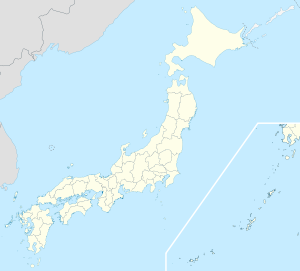

Geographische Lage in Japan Region: Chūgoku Präfektur: Shimane Koordinaten: 35° 1′ N, 132° 13′ O35.011388888889132.22111111111Koordinaten: 35° 0′ 41″ N, 132° 13′ 16″ O Basisdaten Fläche: 269,5 km² Einwohner: 25.454
(1. Juli 2011)Bevölkerungsdichte: 94 Einwohner je km² Gemeindeschlüssel: 32207-5 Symbole Baum: Japanische Schwarzkiefer Blume: Azalee Rathaus Adresse: Gōtsu City Hall
1525 Gōtsu-chō
Gōtsu-shi
Shimane 695-8501Webadresse: http://www.city.gotsu.shimane.jp Lage Gōtsus in der Präfektur Shimane 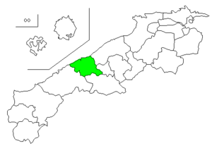
Gōtsu (jap. 江津市, -shi) ist eine Stadt in der Präfektur Shimane in Japan.
Inhaltsverzeichnis
Geschichte
Die Stadt Gōtsu wurde am 1. April 1954 gegründet
Verkehr
- Zug:
- JR Sanin-Hauptlinie
- JR Sankō-Linie
- Straße:
- Sanin-Autobahn
- Nationalstraße 9
- Nationalstraße 186,261
Städtepartnerschaften
Söhne und Töchter der Stadt
- Masashi Tanaka (Manga-Zeichner)
Angrenzende Städte und Gemeinden
Weblinks
 Commons: Gōtsu – Sammlung von Bildern, Videos und Audiodateien
 Gemeinden und Landkreise in der Präfektur Shimane
Kreisfreie Städte (shi): Gōtsu | Hamada | Izumo | Masuda | Matsue (Verwaltungssitz) | Ōda | Unnan | Yasugi
Hikawa-gun: Hikawa | Iishi-gun: Iinan | Kanoashi-gun: Tsuwano | Yoshika | Nita-gun: Okuizumo | Ōchi-gun: Kawamoto | Misato | Ōnan | Oki-gun: Ama | Chibu | Nishinoshima | Okinoshima | Yatsuka-gun: Higashiizumo
Wikimedia Foundation.
Schlagen Sie auch in anderen Wörterbüchern nach:
Gotsu — 江津市 Gōtsu shi DEC … Deutsch Wikipedia
Gotsu — Original name in latin Gtsu Name in other language Gatsu, Gotsu, Gotu, Gozu, Gtsu, Gtu, Gzu State code JP Continent/City Asia/Tokyo longitude 35 latitude 132.21667 altitude 22 Population 24597 Date 2012 01 19 … Cities with a population over 1000 database
Gōtsu, Shimane — nihongo|Gōtsu|江津市|Gōtsu shi is a city located in Shimane Prefecture, Japan.The city was founded on April 1, 1954. As of 2003, the city has an estimated population of 25,064 and the density of 158.22 persons per km². The total area is 158.41… … Wikipedia
Gotsu Shi — Admin ASC 2 Code Orig. name Gōtsu Shi Country and Admin Code JP.36.1863519 JP … World countries Adminstrative division ASC I-II
Chigane Station — 千金駅 Location Prefecture Shimane (See other stations in Shimane) City Gōtsu Neighborhood etc … Wikipedia
Shimane Prefecture — Infobox Prefecture Japan Name = Shimane JapaneseName = 島根県 Rōmaji = Shimane ken Symbol = PrefSymbol Shimane.png Capital = Matsue Region = Chūgoku Island = Honshū TotalArea = 6,707.29 AreaRank = 18th PCWater = 2.7 PopDate = October 1, 2000… … Wikipedia
Miyoshi Station (Hiroshima) — Miyoshi Station 三次駅 Station front Location … Wikipedia
Гоцу — Город Гоцу яп. 江津市 Страна ЯпонияЯпония … Википедия
Ōda, Shimane — Ooda redirects here. For the strategic process, see OODA loop. Ōda 大田市 City … Wikipedia
Ōchi District, Shimane — Ōchi (邑智郡, Ōchi gun?) is a district located in Shimane, Japan. As of 2003, the district has an estimated population of 27,648 and a density of 30.10 persons per km². The total area is 918.63 km². Towns and villages Kawamoto Misato … Wikipedia
- Zug:
Gōtsu


18+
© Academic, 2000-2024
- Kontaktieren Sie uns: Unterstützung, Werbung
Wörterbücher Export, schritte mit PHP, Joomla, Drupal, WordPress, MODx.