Gwydir Shire

Gwydir Shire
Shire of Gwydir
Australia-Map-NSW-LGA-Gwydir.png
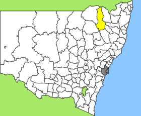
Lage des Gwydir Shire in New South Wales
Gliederung
Staat: Australien Australien
Bundesstaat: Flag of New South Wales.svg New South Wales
Verwaltungssitz: Bingara
Daten und Zahlen
Fläche: 9.453 km²
Einwohner: 5.311 (2006) [1]
Bevölkerungsdichte: 0,6 Einwohner je km²
-29.866666666667150.56666666667

Gwydir Shire ist ein lokales Verwaltungsgebiet (LGA) im australischen Bundesstaat New South Wales. Das Gebiet ist 9.453 km² groß und hat etwa 5.300 Einwohner.

Gwydir liegt an der Nordostgrenze des Staates zu Queensland etwa 580 km nördlich der Metropole Sydney und 500 km südöstlich von Brisbane. Das Gebiet umfasst 68 Ortsteile und Ortschaften, darunter Bingara, Upper Bingara, Cobbadah, Coolatai, Crooble, Croppa Creek, Elcombe, Dinoga, Gineroi, Gravesend, Gulf Creek, Horton Valley, Gravesend, Mosquito Creek, North Star, Warialda, Warialda Rail und Yallaroi. Der Sitz des Shire Councils befindet sich in Bingara in der Südhälfte der LGA, wo etwa 1.200 Einwohner leben.

Verwaltung

Der Gwydir Shire Council hat neun Mitglieder, die von den Bewohnern der LGA gewählt werden. Gwydir ist nicht in Bezirke untergliedert. Aus dem Kreis der Councillor rekrutiert sich auch der Mayor (Bürgermeister) des Councils.

Weblinks

Einzelnachweise

  1. Australian Bureau of Statistics (25. Oktober 2007): Gwydir (A) (Local Government Area) (Englisch). 2006 Census QuickStats. Abgerufen am 6. April 2010.

Wikimedia Foundation.

Игры ⚽ Нужен реферат?

Schlagen Sie auch in anderen Wörterbüchern nach:

  • Gwydir Shire Council — Infobox Australian Place | type = lga name = Gwydir Shire state = nsw caption = Location in New South Wales pop = 5,530 cite web publisher = Australian Bureau of Statistics title=Regional Population Growth, Australia, 2004 05 url = http://abs.gov …   Wikipedia

  • Division of Gwydir — Gwydir Australian House of Representatives Division Created: 1901 Abolished: 2007 Namesake: Gwydir River The Division of Gwydir was an A …   Wikipedia

  • Wakool Shire — Shire of Wakool New South Wales Location in New South Wales Population: 4,427(2009) …   Wikipedia

  • Moree Plains Shire — New South Wales Location in New South Wales Population …   Wikipedia

  • Moree Plains Shire Council — Infobox Australian Place | type = lga name = Moree Plains Shire state = nsw caption = Location in New South Wales pop = 15,680Census 2001 AUS|id=LGA15300|name=Moree Plains (A) (Local Government Area)|accessdate=2007 06 30] area = 17928 est = seat …   Wikipedia

  • Inverell Shire Council — Infobox Australian Place | type = lga name = Inverell Shire caption = Location in New South Wales state=New South Wales region=North West Slopes area=8606 est = seat=Inverell (144 Otho Street)cite web title=Inverell Shire Council publisher =… …   Wikipedia

  • Narrabri Shire — New South Wales Population: 13,693(2009) …   Wikipedia

  • Narrabri Shire Council — Infobox Australian Place | type = lga name = Narrabri Shire state = nsw caption = pop = 13,800 Census 2001 AUS|id=LGA15750|name=Narrabri (A) (Local Government Area)|accessdate=2007 06 30|quick=on] area = 13031 est = seat = Narrabri (46 48… …   Wikipedia

  • Muswellbrook Shire — New South Wales Location in New South Wales Population …   Wikipedia

  • Conargo Shire — New South Wales Location in New South Wales Population: 1,700(2009) …   Wikipedia

Share the article and excerpts

Direct link
Do a right-click on the link above
and select “Copy Link”