Gunnedah Shire

Gunnedah Shire
Shire of Gunnedah
Australia-Map-NSW-LGA-Gunnedah.png
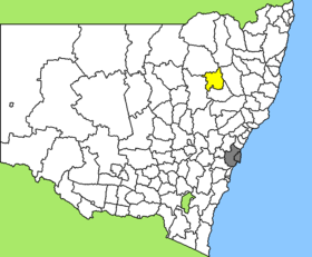
Lage des Gunnedah Shire in New South Wales
Gliederung
Staat: Australien Australien
Bundesstaat: Flag of New South Wales.svg New South Wales
Verwaltungssitz: Gunnedah
Daten und Zahlen
Fläche: 4.994 km²
Einwohner: 11.525 (2006) [1]
Bevölkerungsdichte: 2,3 Einwohner je km²
-30.966666666667150.25

Gunnedah Shire ist ein lokales Verwaltungsgebiet (LGA) im australischen Bundesstaat New South Wales. Das Gebiet ist 4.994 km² groß und hat etwa 11.500 Einwohner.

Gunnedah liegt im Nordosten des Staates etwa 450 km nördlich der Metropole Sydney und 650 km südwestlich von Brisbane. Das Gebiet umfasst 37 Ortsteile und Ortschaften, darunter Breeza, Carroll, Carroll Gap, Coocooboonah, Curlewis, Emerald Hill, Gunnedah, Kelvin, Meermaul, Mullaley, Piallaway, Tambar Springs. Der Sitz des Shire Councils befindet sich in Gunnedah im Zentrum der LGA, wo etwa 7.500 Einwohner leben.

Verwaltung

Der Gunnedah Shire Council hat neun Mitglieder, die von den Bewohnern der LGA gewählt werden. Gunnedah ist nicht in Bezirke untergliedert. Aus dem Kreis der Councillor rekrutiert sich auch der Mayor (Bürgermeister) des Councils.

Weblinks

Einzelnachweise

  1. Australian Bureau of Statistics (25. Oktober 2007): Gunnedah (A) (Local Government Area) (Englisch). 2006 Census QuickStats. Abgerufen am 6. April 2010.

Wikimedia Foundation.

Игры ⚽ Нужно решить контрольную?

Schlagen Sie auch in anderen Wörterbüchern nach:

  • Gunnedah Shire Council — Infobox Australian Place | type = lga name = Gunnedah Shire caption = Location in New South Wales state=New South Wales region=North West Slopes area=4994 est = seat=Gunnedah (63 Elgin Street} cite web title=Gunnedah Shire Council publisher =… …   Wikipedia

  • Gunnedah, New South Wales — Infobox Australian Place | type = town name = Gunnedah state = nsw caption = Gunnedah viewed from Mt Porcupine. lga = Gunnedah Shire Council county = Pottinger postcode = 2380 est = 1833 pop = 7,542 (2006) elevation= 264 maxtemp = mintemp =… …   Wikipedia

  • Liverpool Plains Shire Council — Infobox Australian Place | type = lga name = Liverpool Plains Shire state = nsw caption = Location in New South Wales pop = 7,910 density = 1.55 area = 5086 est = seat = Quirindi (60 Station Street mayor = Ian Lobsey region = North West Slopes… …   Wikipedia

  • Wakool Shire — Shire of Wakool New South Wales Location in New South Wales Population: 4,427(2009) …   Wikipedia

  • Narrabri Shire — New South Wales Population: 13,693(2009) …   Wikipedia

  • Muswellbrook Shire — New South Wales Location in New South Wales Population …   Wikipedia

  • Conargo Shire — New South Wales Location in New South Wales Population: 1,700(2009) …   Wikipedia

  • Murray Shire — This article is about the Murray Shire in New South Wales. For the Western Australia shire, see Shire of Murray. Murray Shire New South Wales …   Wikipedia

  • Narrandera Shire — New South Wales Location in New South Wales Population: 6 …   Wikipedia

  • Cowra Shire — New South Wales Location in NSW Population: 12,945(2009) …   Wikipedia

Share the article and excerpts

Direct link
Do a right-click on the link above
and select “Copy Link”