- Guilhufe
-
Guilhufe Wappen Karte 
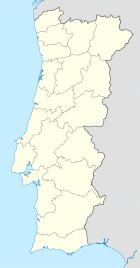

Basisdaten Region: Norte Unterregion: Tâmega Distrikt: Porto Concelho: Penafiel Koordinaten: 41° 12′ N, 8° 17′ W41.203888888889-8.2772222222222Koordinaten: 41° 12′ N, 8° 17′ W Einwohner: 2.621 (Stand: 2001) Fläche: 4,45 km² Bevölkerungsdichte: 589 Einwohner pro km² Guilhufe ist eine Gemeinde im Norden Portugals.
Guilhufe gehört zum Kreis Penafiel im Distrikt Porto, besitzt eine Fläche von 4,45 km² und hat 2.621 Einwohner (2001).
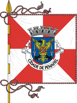
Wappen
In Rot umgeben drei (2;1) goldene Weinreben mit silbernen Blättern ein silbernes Zahnrad. Auf dem Schild ruht eine dreitürmige Mauerkrone. Im weißen Band am Schildfuß der Ortsname in schwarzen Buchstaben „GUILHUFE -PENAFIEL“.
Weblinks
- Karte der Freguesia Guilhufe beim Instituto Geográfico do Exército
 Freguesias im Concelho Penafiel
Abragão | Boelhe | Bustelo | Cabeça Santa | Canelas | Capela | Castelões | Croca | Duas Igrejas | Eja | Figueira | Fonte Arcada | Galegos | Guilhufe | Irivo | Lagares | Luzim | Marecos | Milhundos | Novelas | Oldrões | Paço de Sousa | Penafiel | Perozelo | Pinheiro | Portela | Rans | Rio de Moinhos | Santa Marta | Santiago de Subarrifana | São Mamede de Recezinhos | São Martinho de Recezinhos | São Miguel de Paredes | Sebolido | Urrô | Valpedre | Vila Cova
Wikimedia Foundation.
Schlagen Sie auch in anderen Wörterbüchern nach:
Guilhufe — Freguesia de Portugal … Wikipedia Español
Autoroute portugaise A4 — Autoroute Porto Quintanilha A 4 Longueur 88 km (223 km) De Matosinhos Intersections … Wikipédia en Français
Районы округа Порту — … Википедия
Гильуфе — Район Гильуфе Guilhufe Герб … Википедия
List of postal codes in Portugal — Aveiro districtMealhada municipality*3050 Antes *3050 Barcouço *3050 Casal Comba *3050 Luso *3050 Mealhada *3050 Pampilhosa *3050 Vacariça *3050 Ventosa do BairroMurtosa municipality*3870 Bunheiro *3870 Monte *3870 Murtosa *3870 TorreiraOliveira… … Wikipedia
Penafiel — (pron. IPA2|pɨnɐfi ɛɫ or [IPA|penɐfi ɛɫ] ) is a Portuguese city of the Porto district in the North of the country.The city of Penafiel itself had, as of 2001, a population of 9,343. The municipal areas surrounding Penafiel City have a population… … Wikipedia
Abragão — Wappen Karte … Deutsch Wikipedia
Boelhe — Wappen Karte … Deutsch Wikipedia
Bustelo (Penafiel) — Bustelo Wappen Karte … Deutsch Wikipedia
Cabeça Santa — Wappen Karte … Deutsch Wikipedia
Guilhufe


18+
© Academic, 2000-2024
- Kontaktieren Sie uns: Unterstützung, Werbung
Wörterbücher Export, schritte mit PHP, Joomla, Drupal, WordPress, MODx.