- Guilford County
-
Verwaltung US-Bundesstaat: North Carolina Verwaltungssitz: Greensboro Adresse des
Verwaltungssitzes:County Courthouse
P.O. Box 3427
Greensboro, NC 27402-3427Gründung: 1770 Gebildet aus: Rowan County Vorwahl: 001 336 Demographie Einwohner: 421.048 (2000) Bevölkerungsdichte: 250,3 Einwohner/km² Geographie Fläche gesamt: 1.703 km² Wasserfläche: 21 km² Karte 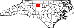
Website: www.co.guilford.nc.us Guilford County[1] ist ein County im Bundesstaat North Carolina der Vereinigten Staaten von Amerika. Der Verwaltungssitz (County Seat) ist Greensboro, das nach Nathaniel Greene, einem General im Amerikanischen Unabhängigkeitskrieg benannt wurde.
Inhaltsverzeichnis
Geografie
Das County liegt nordwestlich des geographischen Zentrums von North Carolina, ist im Norden etwa 40 km von Virginia entfernt und hat eine Fläche von 1703 Quadratkilometern, wovon 21 Quadratkilometer Wasserfläche sind. Es grenzt im Uhrzeigersinn an folgende Countys: Rockingham County, Alamance County, Randolph County, Davidson County und Forsyth County.
Guilford County ist in 18 Townships aufgeteilt: Bruce, Center Grove, Clay, Deep River, Fentress, Friendship, Gilmer, Greene, High Point, Jamestown, Jefferson, Madison, Monroe, Morehead, Oak Ridge, Rock Creek, Sumner und Washington.
Geschichte
Guilford County wurde 1770 aus Teilen des Rowan County gebildet. Benannt wurde es nach Francis North, 1. Earl Guilford.
Demografische Daten
Historische Einwohnerzahlen Census Einwohner ± in % 1790 7191 — 1800 9442 30 % 1810 11.420 20 % 1820 14.511 30 % 1830 18.737 30 % 1840 19.175 2 % 1850 19.751 3 % 1860 20.056 2 % 1870 21.736 8 % 1880 23.585 9 % 1890 28.052 20 % 1900 39.074 40 % 1910 60.497 50 % 1920 79.272 30 % 1930 133.010 70 % 1940 153.916 20 % 1950 191.057 20 % 1960 246.520 30 % 1970 288.590 20 % 1980 317.154 10 % 1990 347.420 10 % 2000 421.048 20 % Vor 1900[2] Nach der Volkszählung im Jahr 2000 lebten im Guilford County 421.048 Menschen in 168.667 Haushalten und 109.802 Familien. Die Bevölkerungsdichte beträgt 250 Einwohner pro Quadratkilometer. Ethnisch betrachtet setzt sich die Bevölkerung zusammen aus 64,53 Prozent Weißen, 29,27 Prozent Afroamerikanern, 0,46 Prozent amerikanischen Ureinwohnern, 2,44 Prozent Asiaten, 0,03 Prozent Bewohnern aus dem pazifischen Inselraum und 1,81 Prozent aus anderen ethnischen Gruppen; 1,45 Prozent stammten von zwei oder mehr Ethnien ab. 3,80 Prozent der Bevölkerung waren spanischer oder lateinamerikanischer Abstammung.
Von den 168.667 Haushalten hatten 30,4 Prozent Kinder unter 18 Jahren, die bei ihnen lebten. 48,0 Prozent davon waren verheiratete, zusammenlebende Paare, 13,4 Prozent waren allein erziehende Mütter und 34,9 Prozent waren keine Familien. 27,9 Prozent waren Singlehaushalte und in 8,3 Prozent lebten Menschen mit 65 Jahren oder älter. Die Durchschnittshaushaltsgröße betrug 2,41 und die durchschnittliche Familiengröße war 2,96 Personen.
23,7 Prozent der Bevölkerung waren unter 18 Jahre alt. 11,0 Prozent zwischen 18 und 24 Jahre, 31,4 Prozent zwischen 25 und 44 Jahre, 22,1 Prozent zwischen 45 und 64, und 11,8 Prozent waren 65 Jahre alt oder Älter. Das Durchschnittsalter betrug 35 Jahre. Auf alle weibliche Personen kamen 92,0 männliche Personen. Auf alle Frauen im Alter von 18 Jahren oder darüber kamen 88,6 Männer.
Das jährliche Durchschnittseinkommen eines Haushalts betrug 42.618 $ und das jährliche Durchschnittseinkommen einer Familie betrug 52.638 $. Männer hatten ein durchschnittliches Einkommen von 35.940 $ gegenüber den Frauen mit 27.092 $. Das Prokopfeinkommen betrug 23.340 $. 10,6 Prozent der Bevölkerung und 7,6 Prozent der Familien lebten unterhalb der Armutsgrenze. 13,8 Prozent von ihnen sind Kinder und Jugendliche unter 18 Jahre und 9,9 Prozent sind 65 Jahre oder älter. [5]
Siehe auch
Einzelnachweise
- ↑ GNIS-ID: 1008558. Abgerufen am 22. Februar 2011 (englisch).
- ↑ U.S. Census Bureau - Census of Population and Housing. Abgerufen am 15. März 2011
- ↑ Auszug aus Census.gov. Abgerufen am 20. Februar 2011
- ↑ Auszug aus factfinder.census.gov Abgerufen am 20. Februar 2011
- ↑ Guilford County, North Carolina, Datenblatt mit den Ergebnissen der Volkszählung im Jahre 2000 bei factfinder.census.gov.

Liste der Countys in North Carolina
Alamance | Alexander | Alleghany | Anson | Ashe | Avery | Beaufort | Bertie | Bladen | Brunswick | Buncombe | Burke | Cabarrus | Caldwell | Camden | Carteret | Caswell | Catawba | Chatham | Cherokee | Chowan | Clay | Cleveland | Columbus | Craven | Cumberland | Currituck | Dare | Davidson | Davie | Duplin | Durham | Edgecombe | Forsyth | Franklin | Gaston | Gates | Graham | Granville | Greene | Guilford | Halifax | Harnett | Haywood | Henderson | Hertford | Hoke | Hyde | Iredell | Jackson | Johnston | Jones | Lee | Lenoir | Lincoln | Macon | Madison | Martin | McDowell | Mecklenburg | Mitchell | Montgomery | Moore | Nash | New Hanover | Northampton | Onslow | Orange | Pamlico | Pasquotank | Pender | Perquimans | Person | Pitt | Polk | Randolph | Richmond | Robeson | Rockingham | Rowan | Rutherford | Sampson | Scotland | Stanly | Stokes | Surry | Swain | Transylvania | Tyrrell | Union | Vance | Wake | Warren | Washington | Watauga | Wayne | Wilkes | Wilson | Yadkin | Yancey
Wikimedia Foundation.
Schlagen Sie auch in anderen Wörterbüchern nach:
Guilford County — Admin ASC 2 Code Orig. name Guilford County Country and Admin Code US.NC.081 US … World countries Adminstrative division ASC I-II
Guilford County, North Carolina — Infobox U.S. County county = Guilford County state = North Carolina map size = 250 founded = 1771 seat = Greensboro | area total sq mi =658 area land sq mi =649 area water sq mi =8 area percentage = 1.26% census yr = 2007 (est.) pop = 465,931… … Wikipedia
Guilford County Schools — Infobox School System name = Guilford County Schools motto = Striving. Achieving. Excelling. superintendent = Maurice Mo Green faculty = 8,469 (Full Time) students = 70,426 location = North Carolina esnum = 65 msnum = 22 hsnum = 25 website =… … Wikipedia
National Register of Historic Places listings in Guilford County, North Carolina — Map of all coordinates from Google Map of all coordinates from Bing … Wikipedia
Monticello, Guilford County, North Carolina — Monticello Unincorporated area … Wikipedia
Guilford Technical Community College — (GTCC) is a two year accredited community college in Guilford County, North Carolina. GTCC offers certificates, one year and two year career related programs, a two year college transfer program, personal enrichment courses, a variety of adult… … Wikipedia
Guilford — ist der Name mehrerer Orte in Großbritannien: Guilford (Surrey) in den Vereinigten Staaten: Guilford (Connecticut) Guilford (Indiana) Guilford (Maine) Guilford (Maryland) Guilford (Missouri) Guilford (New York) Guilford (North Carolina) Guilford… … Deutsch Wikipedia
Guilford Court House, North Carolina — Guilford Court House, North Carolina, was the county seat of Guilford County before being replaced by Greensboro. It was the site of the Battle of Guilford Court House, which is now commemorated at Guilford Courthouse National Military Park … Wikipedia
Guilford Middle School — is a middle school in Greensboro, North Carolina. HistoryHistory traces the school back to the mid 1890s. The name Guilford Middle didn t come up until around the 1930s. During the 30s the school included kindergarten to 12 grade. Current… … Wikipedia
Guilford Native American Association — The Guilford Native American Association (GNAA) is a Native American community association in Guilford County, North Carolina. The GNAA is a North Carolina State recognized American Indian Organization , [cite journal | author = | title =… … Wikipedia
Guilford County

18+
© Academic, 2000-2024
- Kontaktieren Sie uns: Unterstützung, Werbung
Wörterbücher Export, schritte mit PHP, Joomla, Drupal, WordPress, MODx.