- Greenwood County (Kansas)
-
Verwaltung US-Bundesstaat: Kansas Verwaltungssitz: Eureka Adresse des
Verwaltungssitzes:County Courthouse
311 N. Main Street
Eureka, KS 67045-1321Gründung: 25. August 1855 Vorwahl: 001 620 Demographie Einwohner: 7673 (2000) Bevölkerungsdichte: 2,6 Einwohner/km² Geographie Fläche gesamt: 2.985 km² Wasserfläche: 33 km² Karte 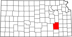
Website: www.greenwoodcounty.org Greenwood County[1] ist ein County im Bundesstaat Kansas der Vereinigten Staaten von Amerika. Der Verwaltungssitz (County Seat) ist Eureka.
Inhaltsverzeichnis
Geografie
Das County liegt im mittleren Südosten von Kansas, ist im Süden etwa 70 km vom Oklahoma entfernt und hat eine Fläche von 2985 Quadratkilometern, wovon 33 Quadratkilometer Wasserfläche sind. Es grenzt im Uhrzeigersinn an folgende Countys: Lyon County, Coffey County, Woodson County, Wilson County, Elk County, Butler County und Chase County.
Geschichte
Greenwood County wurde am 25. August 1855 gebildet und gehört zu den ersten 33 Countys, die von der ersten Territorial-Verwaltung gebildet wurden. Benannt wurde es nach Alfred B. Greenwood, einem US-Commissioner für indianische Angelegenheiten.
Demografische Daten
Historische Einwohnerzahlen Census Einwohner ± in % 1860 769 — 1870 3484 400 % 1880 10.548 200 % 1890 16.309 50 % 1900 16.196 -0,7 % 1910 16.060 -0,8 % 1920 14.715 -8 % 1930 19.235 30 % 1940 16.495 -10 % 1950 13.574 -20 % 1960 11.253 -20 % 1970 9141 -20 % 1980 8764 -4 % 1990 7847 -10 % 2000 7673 -2 % Vor 1900[2] 1900–1990[3]
 Alterspyramide für das Greenwood County
Nach der Volkszählung im Jahr 2000 lebten im Greenwood County 7673 Menschen in 3234 Haushalten und 2153 Familien im Greenwood County. Die Bevölkerungsdichte betrug 3 Einwohner pro Quadratkilometer. Ethnisch betrachtet setzte sich die Bevölkerung zusammen aus 96,53 Prozent Weißen, 0,14 Prozent Afroamerikanern, 0,83 Prozent amerikanischen Ureinwohnern, 0,10 Prozent Asiaten und 0,81 Prozent aus anderen ethnischen Gruppen; 1,58 Prozent stammten von zwei oder mehr Ethnien ab. 1,72 Prozent der Bevölkerung waren spanischer oder lateinamerikanischer Abstammung.
 Karte des Greenwood Countys
Von den 3234 Haushalten hatten 27,1 Prozent Kinder unter 18 Jahren, die mit ihnen gemeinsam lebten. 56,5 Prozent waren verheiratete, zusammenlebende Paare, 6,6 Prozent waren allein erziehende Mütter und 33,4 Prozent waren keine Familien. 30,3 Prozent aller Haushalte waren Singlehaushalte und in 16,8 Prozent lebten Menschen mit 65 Jahren oder darüber. Die Durchschnittshaushaltsgröße betrug 2,31 und die durchschnittliche Familiengröße betrug 2,86 Personen.
23,7 Prozent der Bevölkerung waren unter 18 Jahre alt. 6,5 Prozent zwischen 18 und 24 Jahre, 23,2 Prozent zwischen 25 und 44 Jahre, 23,7 Prozent zwischen 45 und 64 Jahre und 22,8 Prozent waren 65 Jahre alt oder älter. Das Durchschnittsalter betrug 43 Jahre. Auf 100 weibliche Personen kamen 95,5 männliche Personen. Auf 100 erwachsene Frauen ab 18 Jahren kamen 91,5 Männer.
Das jährliche Durchschnittseinkommen eines Haushalts betrug 30.169 USD, das Durchschnittseinkommen einer Familie betrug 38.140 USD. Männer hatten ein Durchschnittseinkommen von 27.021 USD, Frauen 19.356 USD. Das Prokopfeinkommen betrug 15.976 USD. 8,2 Prozent der Familien und 12,5 Prozent der Bevölkerung lebten unterhalb der Armutsgrenze. [4]
Siehe auch
Einzelnachweise
- ↑ GNIS-ID: 485003. Abgerufen am 22. Februar 2011 (englisch).
- ↑ U.S. Census Bureau - Census of Population and Housing. Abgerufen am 15. März 2011
- ↑ Auszug aus Census.gov. Abgerufen am 17. Februar 2011
- ↑ Greenwood County, Kansas, Datenblatt mit den Ergebnissen der Volkszählung im Jahre 2000 bei factfinder.census.gov.
Weblinks
- Homepage Kansas Government (engl.)

Liste der Countys in Kansas
Allen | Anderson | Atchison | Barber | Barton | Bourbon | Brown | Butler | Chase | Chautauqua | Cherokee | Cheyenne | Clark | Clay | Cloud | Coffey | Comanche | Cowley | Crawford | Decatur | Dickinson | Doniphan | Douglas | Edwards | Elk | Ellis | Ellsworth | Finney | Ford | Franklin | Geary | Gove | Graham | Grant | Gray | Greeley | Greenwood | Hamilton | Harper | Harvey | Haskell | Hodgeman | Jackson | Jefferson | Jewell | Johnson | Kearny | Kingman | Kiowa | Labette | Lane | Leavenworth | Lincoln | Linn | Logan | Lyon | Marion | Marshall | McPherson | Meade | Miami | Mitchell | Montgomery | Morris | Morton | Nemaha | Neosho | Ness | Norton | Osage | Osborne | Ottawa | Pawnee | Phillips | Pottawatomie | Pratt | Rawlins | Reno | Republic | Rice | Riley | Rooks | Rush | Russell | Saline | Scott | Sedgwick | Seward | Shawnee | Sheridan | Sherman | Smith | Stafford | Stanton | Stevens | Sumner | Thomas | Trego | Wabaunsee | Wallace | Washington | Wichita | Wilson | Woodson | Wyandotte
Wikimedia Foundation.
Schlagen Sie auch in anderen Wörterbüchern nach:
Greenwood County, Kansas — Infobox U.S. County county=Greenwood County state=Kansas founded=August 25, 1855 seat=Eureka area total km2=2985|area total sq mi=1153 area land km2=2952|area land sq mi=1140 area water km2=33|area water sq mi=13 area percentage=1.12% census… … Wikipedia
National Register of Historic Places listings in Greenwood County, Kansas — Location of Greenwood County in Kansas This is a list of the National Register of Historic Places listings in Greenwood County, Kansas. This is intended to be a complete list of the properties on the National Register of Historic Places in… … Wikipedia
Otter Creek Township, Greenwood County, Kansas — Otter Creek Township Township Location in Greenwood County … Wikipedia
Eureka Township, Greenwood County, Kansas — Infobox Settlement official name = Eureka Township settlement type = Township nickname = motto = imagesize = image caption = image imagesize = image caption = image mapsize = map caption = Location in Greenwood County mapsize1 = map caption1 =… … Wikipedia
Bachelor Township, Greenwood County, Kansas — Infobox Settlement official name = Bachelor Township settlement type = Township nickname = motto = imagesize = image caption = image imagesize = image caption = image mapsize = map caption = Location in Greenwood County mapsize1 = map caption1 =… … Wikipedia
Fall River Township, Greenwood County, Kansas — Infobox Settlement official name = Fall River Township settlement type = Township nickname = motto = imagesize = image caption = image imagesize = image caption = image mapsize = map caption = Location in Greenwood County mapsize1 = map caption1 … Wikipedia
Janesville Township, Greenwood County, Kansas — Infobox Settlement official name = Janesville Township settlement type = Township nickname = motto = imagesize = image caption = image imagesize = image caption = image mapsize = map caption = Location in Greenwood County mapsize1 = map caption1 … Wikipedia
Lane Township, Greenwood County, Kansas — Infobox Settlement official name = Lane Township settlement type = Township nickname = motto = imagesize = image caption = image imagesize = image caption = image mapsize = map caption = Location in Greenwood County mapsize1 = map caption1 =… … Wikipedia
Madison Township, Greenwood County, Kansas — Infobox Settlement official name = Madison Township settlement type = Township nickname = motto = imagesize = image caption = image imagesize = image caption = image mapsize = map caption = Location in Greenwood County mapsize1 = map caption1 =… … Wikipedia
Pleasant Grove Township, Greenwood County, Kansas — Infobox Settlement official name = Pleasant Grove Township settlement type = Township nickname = motto = imagesize = image caption = image imagesize = image caption = image mapsize = map caption = Location in Greenwood County mapsize1 = map… … Wikipedia
Greenwood County (Kansas)


18+
© Academic, 2000-2024
- Kontaktieren Sie uns: Unterstützung, Werbung
Wörterbücher Export, schritte mit PHP, Joomla, Drupal, WordPress, MODx.