Great Cumbrae

Great Cumbrae

Vorlage:Infobox Insel/Wartung/Fläche fehlt

Great Cumbrae
Blick auf Great Cumbrae von Goat Fell aus
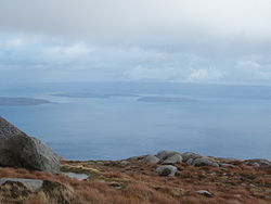
Gewässer Firth of Clyde
Geographische Lage 55° 46′ 8″ N, 4° 55′ 3″ W55.768888888889-4.9175127Koordinaten: 55° 46′ 8″ N, 4° 55′ 3″ W
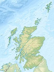
Great Cumbrae (Schottland)
Great Cumbrae
Höchste Erhebung 127 m
Einwohner 2.000 w3
Hauptort Millport
Firthofclydemap.png

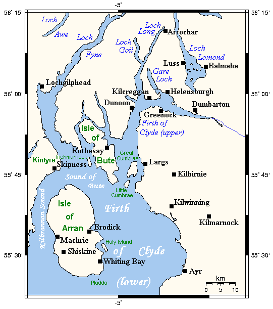
Great Cumbrae (Schott.-gäl.: Cumaradh Mòr) oder Isle of Cumbrae (es gibt eine kleine Schwesterinsel namens Little Cumbrae Island) ist eine kleine Insel im Firth of Clyde an der schottischen Westküste, rund 20 Fährminuten von Largs entfernt.

Hauptort der Insel ist Millport, wo etwa 1600 der 2000 Einwohner der Insel leben. Dort befindet sich auch die Hauptattraktion der Insel - die Cathedral of the Isles, die kleinste Kathedrale Europas. Weitere Sehenswürdigkeiten sind ein bemalter Felsen namens Crocodile Rock an der Nordküste sowie das Marine Life Museum im Südosten. Höchste Erhebung ist der Glaid Stone im Zentrum der Insel mit einer Höhe von 127 Metern. Von dort aus hat man bei gutem Wetter Ausblick auf das Festland, auf die Inseln Bute und Arran sowie auf die Halbinsel Kintyre.


Wikimedia Foundation.

Игры ⚽ Поможем написать реферат

Schlagen Sie auch in anderen Wörterbüchern nach:

  • Great Cumbrae — Location OS grid reference NS169566 …   Wikipedia

  • Great Cumbrae — Géographie Pays  Royaume Uni Archipel Îles Britanniques L …   Wikipédia en Français

  • Great Cumbrae — Isla Great Cumbrae Cumaradh Mòr Cima del monte Glaidstane, el más alto de la isla Localización País …   Wikipedia Español

  • Little Cumbrae — Isla Little Cumbrae Cumaradh Beag Little Cumbrae vista desde Haylie Brae, en el continente (véase Great Cumbrae en primer plano, a la derecha, y Arran más atrás. Localización País …   Wikipedia Español

  • Little Cumbrae — Infobox Scottish island | latitude=55.72 longitude= 4.95 GridReference=NS148517 celtic name=Cumaradh Beag norse name=Kumrey Litla meaning of name=Possibly Little Island of the Cymry area=313 ha area rank=84 highest elevation=Lighthouse Hill 123 m …   Wikipedia

  • Millport, Isle of Cumbrae — Coordinates: 55°45′07″N 4°55′48″W / 55.752°N 4.930°W / 55.752; 4.930 …   Wikipedia

  • Isle of Cumbrae — Blick auf Great Cumbrae von Goat Fell aus. Great Cumbrae (Schott. gäl.: Cumaradh Mòr) oder Isle of Cumbrae (es gibt eine kleine Schwesterinsel namens Little Cumbrae Island) ist eine kleine Insel im Firth of Clyde an der schottischen Westküste,… …   Deutsch Wikipedia

  • Isle of Cumbrae — Original name in latin Isle of Cumbrae Name in other language Cumaradh Mor, Cumaradh Mr, Cumbrae, Great Cumbrae, Isle of Cumbrae State code GB Continent/City Europe/London longitude 55.76933 latitude 4.91913 altitude 116 Population 1434 Date 2012 …   Cities with a population over 1000 database

  • List of Acts of Parliament of the Great Britain Parliament, 1740-1759 — This is an incomplete list of Acts of the Parliament of Great Britain for the years 1740 1759. For acts passed prior to 1707 see List of Acts of Parliament of the English Parliament and List of Acts of Parliament of the Scottish Parliament.For… …   Wikipedia

  • Острова Фёрт-оф-Клайд — Острова залива Фёрт оф Клайд …   Википедия

Share the article and excerpts

Direct link
Do a right-click on the link above
and select “Copy Link”