- Gove County
-
Verwaltung US-Bundesstaat: Kansas Verwaltungssitz: Gove Adresse des
Verwaltungssitzes:County Courthouse
520 Washington
Gove, KS 67736-0128Gründung: 2. März 1868 Gebildet aus: Original-County Vorwahl: 001 785 Demographie Einwohner: 3068 (2000) Bevölkerungsdichte: 1,1 Einwohner/km² Geographie Fläche gesamt: 2.775 km² Wasserfläche: 0 ha Karte 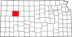
Gove County[1] ist ein County im Bundesstaat Kansas der Vereinigten Staaten von Amerika. Der Verwaltungssitz (County Seat) ist Gove City. Das County gehört zu den Dry Countys, was bedeutet, dass der Verkauf von Alkohol eingeschränkt oder verboten ist.
Inhaltsverzeichnis
Geografie
Das County liegt im mittleren Nordwesten von Kansas und hat eine Fläche von 2775 Quadratkilometern ohne nennenswerte Wasserfläche. Es grenzt im Uhrzeigersinn an folgende Countys: Sheridan County, Graham County, Trego County, Ness County, Scott County, Logan County und Thomas County.
Geschichte
Gove County wurde am 2. März 1868 als Original-County aus freiem Territorium gebildet. Benannt wurde es nach Grenville L. Gove, einem Offizier im Amerikanischen Bürgerkrieg.
Demografische Daten
Historische Einwohnerzahlen Census Einwohner ± in % 1880 1196 — 1890 2994 200 % 1900 2441 -20 % 1910 6044 100 % 1920 4748 -20 % 1930 5643 20 % 1940 4793 -20 % 1950 4447 -7 % 1960 4107 -8 % 1970 3940 -4 % 1980 3726 -5 % 1990 3231 -10 % 2000 3068 -5 % Vor 1900[2] 1900–1990[3]
 Alterspyramide für das Gove County
Nach der Volkszählung im Jahr 2000 lebten im Gove County 3.068 Menschen in 1.245 Haushalten und 861 Familien im Gove County. Die Bevölkerungsdichte betrug 1 Einwohner pro Quadratkilometer. Ethnisch betrachtet setzte sich die Bevölkerung zusammen aus 97,95 Prozent Weißen, 0,10 Prozent Afroamerikanern, 0,16 Prozent amerikanischen Ureinwohnern, 0,10 Prozent Asiaten und 0,72 Prozent aus anderen ethnischen Gruppen; 0,98 Prozent stammten von zwei oder mehr Ethnien ab. 1,24 Prozent der Bevölkerung waren spanischer oder lateinamerikanischer Abstammung.
 Karte des Gove Countys
Von den 1.245 Haushalten hatten 28,4 Prozent Kinder unter 18 Jahren, die mit ihnen gemeinsam lebten. 63,5 Prozent waren verheiratete, zusammenlebende Paare, 3,5 Prozent waren allein erziehende Mütter und 30,8 Prozent waren keine Familien. 29,7 Prozent aller Haushalte waren Singlehaushalte und in 17,5 Prozent lebten Menschen mit 65 Jahren oder darüber. Die Durchschnittshaushaltsgröße betrug 2,42 und die durchschnittliche Familiengröße betrug 3,01 Personen.
26,2 Prozent der Bevölkerung waren unter 18 Jahre alt. 5,4 Prozent zwischen 18 und 24 Jahre, 22,1 Prozent zwischen 25 und 44 Jahre, 23,7 Prozent zwischen 45 und 64 Jahre und 22,7 Prozent waren 65 Jahre alt oder älter. Das Durchschnittsalter betrug 43 Jahre. Auf 100 weibliche Personen kamen 95,2 männliche Personen. Auf 100 erwachsene Frauen ab 18 Jahren kamen 92,3 Männer.
Das jährliche Durchschnittseinkommen eines Haushalts betrug 33.510 USD, das Durchschnittseinkommen einer Familie betrug 40.438 USD. Männer hatten ein Durchschnittseinkommen von 26.863 USD, Frauen 21.357 USD. Das Prokopfeinkommen betrug 17.852 USD.
8,0 Prozent der Familien und 10,3 Prozent der Bevölkerung lebten unterhalb der Armutsgrenze. [4]Orte in Gove County
Städte
- Gove City, 98 Einwohner[5]
- Grainfield, 307 Einwohner[5]
- Grinnell, 308 Einwohner[5]
- Park, 141 Einwohner[5]
- Quinter, 874 Einwohner[5]
Townships
- Baker Township, 1,357 Einwohner[6]
- Gaeland Township, 46 Einwohner[6]
- Gove Township, 215 Einwohner[6]
- Grainfield Township, 430 Einwohner[6]
- Grinnell Township, 480 Einwohner[6]
- Jerome Township, 132 Einwohner[6]
- Larrabee Township, 80 Einwohner[6]
- Lewis Township, 13 Einwohner[6]
- Payne Township, 315 Einwohner[6]
Siehe auch
Einzelnachweise
- ↑ GNIS-ID: 485000. Abgerufen am 22. Februar 2011 (englisch).
- ↑ U.S. Census Bureau - Census of Population and Housing. Abgerufen am 15. März 2011
- ↑ Auszug aus Census.gov. Abgerufen am 17. Februar 2011
- ↑ Gove County, Kansas, Datenblatt mit den Ergebnissen der Volkszählung im Jahre 2000 bei factfinder.census.gov.
- ↑ a b c d e Gove County KS (Englisch), Kansas State Library, 2. Februar 2006. 28. Juli 2007.
- ↑ a b c d e f g h i Kansas Counties (Englisch), Kansas State Historical Society, 2007. 28. Juli 2007.
Weblinks
- Homepage Kansas Government (engl.)

Liste der Countys in Kansas
Allen | Anderson | Atchison | Barber | Barton | Bourbon | Brown | Butler | Chase | Chautauqua | Cherokee | Cheyenne | Clark | Clay | Cloud | Coffey | Comanche | Cowley | Crawford | Decatur | Dickinson | Doniphan | Douglas | Edwards | Elk | Ellis | Ellsworth | Finney | Ford | Franklin | Geary | Gove | Graham | Grant | Gray | Greeley | Greenwood | Hamilton | Harper | Harvey | Haskell | Hodgeman | Jackson | Jefferson | Jewell | Johnson | Kearny | Kingman | Kiowa | Labette | Lane | Leavenworth | Lincoln | Linn | Logan | Lyon | Marion | Marshall | McPherson | Meade | Miami | Mitchell | Montgomery | Morris | Morton | Nemaha | Neosho | Ness | Norton | Osage | Osborne | Ottawa | Pawnee | Phillips | Pottawatomie | Pratt | Rawlins | Reno | Republic | Rice | Riley | Rooks | Rush | Russell | Saline | Scott | Sedgwick | Seward | Shawnee | Sheridan | Sherman | Smith | Stafford | Stanton | Stevens | Sumner | Thomas | Trego | Wabaunsee | Wallace | Washington | Wichita | Wilson | Woodson | Wyandotte
Wikimedia Foundation.
Schlagen Sie auch in anderen Wörterbüchern nach:
Gove County — Admin ASC 2 Code Orig. name Gove County Country and Admin Code US.KS.063 US … World countries Adminstrative division ASC I-II
Gove County, Kansas — Infobox U.S. County county=Gove County state=Kansas founded=March 11, 1868 seat=Gove area total km2=2775|area total sq mi=1071 area land km2=2775|area land sq mi=1071 area water km2=0|area water sq mi=0 area percentage=0.01% census estimate… … Wikipedia
Gove Township, Gove County, Kansas — Infobox Settlement official name = Gove Township settlement type = Township nickname = motto = imagesize = image caption = image imagesize = image caption = image mapsize = map caption = Location in Gove County mapsize1 = map caption1 =… … Wikipedia
Jerome Township, Gove County, Kansas — Jerome Township Township Location in Gove County … Wikipedia
Baker Township, Gove County, Kansas — Infobox Settlement official name = Baker Township settlement type = Township nickname = motto = imagesize = image caption = image imagesize = image caption = image mapsize = map caption = Location in Gove County mapsize1 = map caption1 =… … Wikipedia
Gaeland Township, Gove County, Kansas — Infobox Settlement official name = Gaeland Township settlement type = Township nickname = motto = imagesize = image caption = image imagesize = image caption = image mapsize = map caption = Location in Gove County mapsize1 = map caption1 =… … Wikipedia
Grainfield Township, Gove County, Kansas — Infobox Settlement official name = Grainfield Township settlement type = Township nickname = motto = imagesize = image caption = image imagesize = image caption = image mapsize = map caption = Location in Gove County mapsize1 = map caption1 =… … Wikipedia
Grinnell Township, Gove County, Kansas — Infobox Settlement official name = Grinnell Township settlement type = Township nickname = motto = imagesize = image caption = image imagesize = image caption = image mapsize = map caption = Location in Gove County mapsize1 = map caption1 =… … Wikipedia
Larrabee Township, Gove County, Kansas — Infobox Settlement official name = Larrabee Township settlement type = Township nickname = motto = imagesize = image caption = image imagesize = image caption = image mapsize = map caption = Location in Gove County mapsize1 = map caption1 =… … Wikipedia
Lewis Township, Gove County, Kansas — Infobox Settlement official name = Lewis Township settlement type = Township nickname = motto = imagesize = image caption = image imagesize = image caption = image mapsize = map caption = Location in Gove County mapsize1 = map caption1 =… … Wikipedia
Gove County


18+
© Academic, 2000-2024
- Kontaktieren Sie uns: Unterstützung, Werbung
Wörterbücher Export, schritte mit PHP, Joomla, Drupal, WordPress, MODx.