- Gorreto
-
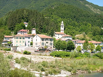
Gorreto 

Staat: Italien Region: Ligurien Provinz: Genua (GE) Koordinaten: 44° 36′ N, 9° 18′ O44.6047222222229.2972222222222533Koordinaten: 44° 36′ 17″ N, 9° 17′ 50″ O Höhe: 533 m s.l.m. Fläche: 18,5 km² Einwohner: 113 (31. Dez. 2010)[1] Bevölkerungsdichte: 6 Einw./km² Postleitzahl: 16020 Vorwahl: 010 ISTAT-Nummer: 010026 Demonym: Gorretesi Schutzpatron: San Fermo Gorreto ist eine kleine Gemeinde in der italienischen Provinz Genua mit 113 Einwohnern (Stand 31. Dezember 2010).

Lage
Die Gemeinde liegt am Fluss Trebbia im gleichnamigen Tal und befindet sich 63 Kilometer entfernt von der ligurischen Hauptstadt Genua.
Zusammen mit weiteren sieben Kommunen bildet Gorreto die Berggemeinde Alta Val Trebbia. Das Gemeindegebiet gehört zum Parco naturale regionale dell'Antola (Regionaler Naturpark Antola).
Nach der italienischen Klassifizierung bezüglich seismischer Aktivität wurde Gorreto der Zone 3 zugeordnet. Das bedeutet, dass sich die Gemeinde in einer seismisch wenig aktiven Zone befindet[2].
Quellen
- ↑ Statistiche demografiche ISTAT. Bevölkerungsstatistiken des Istituto Nazionale di Statistica vom 31. Dezember 2010.
- ↑ Ordinanza PCM n. 3274 vom 20/03/2003
Weblink
 Commons: Gorreto – Album mit Bildern und/oder Videos und Audiodateien
 Gemeinden in der Provinz Genua in der Region Ligurien
Arenzano | Avegno | Bargagli | Bogliasco | Borzonasca | Busalla | Camogli | Campo Ligure | Campomorone | Carasco | Casarza Ligure | Casella | Castiglione Chiavarese | Ceranesi | Chiavari | Cicagna | Cogoleto | Cogorno | Coreglia Ligure | Crocefieschi | Davagna | Fascia | Favale di Malvaro | Fontanigorda | Genua | Gorreto | Isola del Cantone | Lavagna | Leivi | Lorsica | Lumarzo | Masone | Mele | Mezzanego | Mignanego | Mocònesi | Moneglia | Montebruno | Montoggio | Ne | Neirone | Orero | Pieve Ligure | Portofino | Propata | Rapallo | Recco | Rezzoaglio | Ronco Scrivia | Rondanina | Rossiglione | Rovegno | San Colombano Certénoli | Sant’Olcese | Santa Margherita Ligure | Santo Stefano d’Aveto | Savignone | Serra Riccò | Sestri Levante | Sori | Tiglieto | Torriglia | Tribogna | Uscio | Valbrevenna | Vobbia | Zoagli
Wikimedia Foundation.
Schlagen Sie auch in anderen Wörterbüchern nach:
Gorreto — Administration Pays Italie … Wikipédia en Français
Gorreto — Gorreto … Wikipedia Español
Gorreto — Infobox CityIT img coa = official name = Gorreto name = Gorreto region = Liguria province = Province of Genoa (GE) elevation m = 533 area total km2 = 18.6 population as of = Dec. 2004 population total = 147 population density km2 = 8 timezone =… … Wikipedia
Gorreto — Original name in latin Gorreto Name in other language Goreio, Gorreto State code IT Continent/City Europe/Rome longitude 44.60485 latitude 9.29126 altitude 528 Population 147 Date 2012 02 15 … Cities with a population over 1000 database
Trebbia — 45°04′N 9°41′E / 45.067, 9.683 … Wikipédia en Français
Горрето — Коммуна Горрето Gorreto Страна ИталияИталия … Википедия
Val Trebbia — Vue du val Trebbia au sud de Bobbio. Massif Apennins Pays Italie … Wikipédia en Français
Rondanina — Infobox CityIT img coa = official name = Rondanina name = Rondanina region = Liguria province = Province of Genoa (GE) elevation m = 981 area total km2 = 12.7 population as of = Dec. 2004 population total = 83 population density km2 = 7 timezone … Wikipedia
Berggemeinde Alta Val Trebbia — Comunità Montana Alta Val Trebbia Staat: Italien Region: Ligurien Provinz: Genua … Deutsch Wikipedia
Carrega — Ligure … Deutsch Wikipedia
Gorreto


18+
© Academic, 2000-2024
- Kontaktieren Sie uns: Unterstützung, Werbung
Wörterbücher Export, schritte mit PHP, Joomla, Drupal, WordPress, MODx.