Gidy

Gidy
Gidy
Gidy (Frankreich)
Gidy
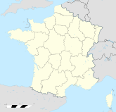
Region Centre
Département Loiret
Arrondissement Orléans
Kanton Artenay
Koordinaten 47° 59′ N, 1° 50′ O47.9869444444441.8366666666667120Koordinaten: 47° 59′ N, 1° 50′ O
Höhe 120 m (117–128 m)
Fläche 23,91 km²
Einwohner 1.502 (1. Jan. 2008)
Bevölkerungsdichte 63 Einw./km²
Postleitzahl 45520
INSEE-Code

Gidy ist eine französische Gemeinde im Département Loiret in der Region Centre mit 1502 Einwohnern (Stand 1. Januar 2008) und liegt etwa 20 km von Orléans entfernt. Bürgermeister ist seit 2001 Andreas Lopès.

Geographie

Mit einer Fläche von 23,8 km² beträgt die Einwohnerdichte etwa 63 Einwohner/km². Die im Internet angegebene Höhe von 131 Metern ist offensichtlich falsch.

Einwohnerentwicklung

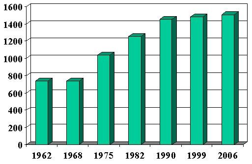
Einwohnerentwicklung seit 1962, in einem Säulendiagramm dargestellt
  • 1962: 735 Einwohner
  • 1968: 736 Einwohner
  • 1975: 1037 Einwohner
  • 1982: 1252 Einwohner
  • 1990: 1450 Einwohner
  • 1999: 1482 Einwohner
  • 2006: 1504 Einwohner

Weblinks


Wikimedia Foundation.

Игры ⚽ Нужен реферат?

Schlagen Sie auch in anderen Wörterbüchern nach:

  • Gidy — País …   Wikipedia Español

  • Gidy — is a village and commune in the Loiret département of northern central France.ee also*Communes of the Loiret department …   Wikipedia

  • Gidy — 47° 59′ 22″ N 1° 50′ 08″ E / 47.989445, 1.835556 …   Wikipédia en Français

  • Gidy — Original name in latin Gidy Name in other language Gidy State code FR Continent/City Europe/Paris longitude 47.98539 latitude 1.83816 altitude 122 Population 1580 Date 2012 01 18 …   Cities with a population over 1000 database

  • gidyə — f. dilənçi, yolçu …   Klassik Azərbaycan ədəbiyyatında islənən ərəb və fars sözləri lüğəti

  • Гиди — (Gidy) дер. во фр. дпт. Луары. Здесь 4 дек. 1870 г. происходила кровавая битва между наступавшим на Орлеан 9 м прусским корпусом и отступавшей луарской армией …   Энциклопедический словарь Ф.А. Брокгауза и И.А. Ефрона

  • Armorial des communes du Loiret — Cette page donne les armoiries (figures et blasonnements) des communes du département français du Loiret. Sur les autres projets Wikimedia : « Armorial des communes du Loiret », sur Wikimedia Commons …   Wikipédia en Français

  • Schlacht bei Orléans — Teil von: Deutsch Französischer Krieg Datum 3. 4. Dezember 1870 Ort Orléans, Arrondissement Orléans …   Deutsch Wikipedia

  • Aire urbaine d'Orléans — Orléans, centre de l aire urbaine L’aire urbaine d Orléans est une aire urbaine française centrée sur la ville d Orléans et répartie sur le territoire des départements du Loiret, de Loir et Cher et de l Eure et Loir, tous situés dans la …   Wikipédia en Français

  • Chevilly (Loiret) — Pour les articles homonymes, voir Chevilly. 48° 01′ 47″ N 1° 52′ 29″ E …   Wikipédia en Français

Share the article and excerpts

Direct link
Do a right-click on the link above
and select “Copy Link”