- Alabama River
-
Alabama River 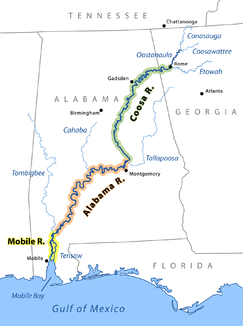
Übersicht von Mobile, Alabama und Coosa River
Daten Gewässerkennzahl US: 154961 Lage Alabama (USA) Flusssystem Mobile River Ursprung Zusammenfluss des Coosa River mit dem Tallapoosa River
32° 30′ 5″ N, 86° 15′ 43″ W32.5015-86.262Zusammenfluss mit dem Tombigbee River zum Mobile River 31.136287-87.943887Koordinaten: 31° 8′ 11″ N, 87° 56′ 38″ W
31° 8′ 11″ N, 87° 56′ 38″ W31.136287-87.943887Länge 502 km Rechte Nebenflüsse Cahaba River Mittelstädte Montgomery Kleinstädte Selma 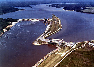
Millers Ferry Lock and Dam am Alabama River
Der Alabama River ist ein Fluss im US-Bundesstaat Alabama. Er entsteht durch den Zusammenfluss des Coosa River mit dem Tallapoosa River ungefähr sechs Meilen von Montgomery entfernt.
Er verläuft westlich bis nach Selma, dann südwestlich, bis er sich etwa 72 km von Mobile entfernt mit dem Tombigbee River vereinigt, welche sich dort wieder zum Mobile River und Tensaw River teilen. Diese laufen parallel nebeneinander, bis sie in der Mobile Bay wieder zusammenfließen.
Die Breite des Flusses variiert zwischen 200 und 300 m, seine Tiefe liegt zwischen ein und zwei Metern. Nach Messung der US Geological Survey hat der Fluss eine Länge von 502 km, nach Messungen der Stadt Steamboat gar 676 km.
Der Alabama River durchfließt reiche landwirtschaftliche Nutzfläche und wird durch Eisenbahnlinien mit der Mineralregion im zentralen Nordalabama verbunden.
Namensvarianten
Der Fluss besitzt mehrere Bezeichnungsvarianten:
- Alabama Fiume[1]
- Albama River[2]
- Halibama River[3]
- Moville River[4]
- Piache[5]
- Riviere des Alibamons[6]
- Río de Mobila[7]
Siehe auch
Einzelnachweise
- ↑ Fite, Emerson D., and Archibald Freeman. A Book of Old Maps. New York: Arno Press, 1926. Reprint, 1969. Delineates American history from the time of the Vikings to the end of the American Revolution. Each map is excellently annotated. p277
- ↑ Swift, Michael. Historical Maps of North America. London: PRC Publishing, 2001. Contains maps from the Public Records Office. p55
- ↑ Swift, Michael. Historical Maps of North America. London: PRC Publishing, 2001. Contains maps from the Public Records Office. p69
- ↑ Swift, Michael. Historical Maps of North America. London: PRC Publishing, 2001. Contains maps from the Public Records Office. p64
- ↑ Weddle, Robert S. Spanish Sea: The Gulf of Mexico in North American Discovery, 1500 1685. College Station, Texas: Texas A&M University Press, 1985. p268
- ↑ Foscue, Virginia. Place Names in Alabama. Tuscaloosa, Alabama : University of Alabama Press, 1989. p7
- ↑ Weddle, Robert S. Spanish Sea: The Gulf of Mexico in North American Discovery, 1500 1685. College Station, Texas: Texas A&M University Press, 1985. p9
Alabama River im Geographic Names Information System des United States Geological Survey
Kategorien:- Fluss in Alabama
- Fluss in Nordamerika
- Flusssystem Mobile River


Wikimedia Foundation.