- Etobicoke
-
Etobicoke 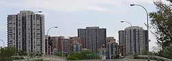
Skyline von EtobicokeLage in Ontario 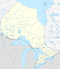

Etobicoke Staat: Kanada Provinz: Ontario Stadtteil von: Toronto Koordinaten: 43° 39′ N, 79° 31′ W43.644444-79.523056Koordinaten: 43° 39′ N, 79° 31′ W Fläche: 123,93 km² Einwohner: 338.117 (Stand: 2001) Bevölkerungsdichte: 2.728,3 Einw./km² Zeitzone: Eastern Time (UTC−5) Postleitzahl: M8V-M9C, M9P-M9R, M9V-M9W Bürgermeister: Rob Ford 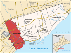
Lage von Etobicoke (rot) in TorontoEtobicoke [ɛˈtoʊ̯bɪˌkoʊ̯] ist ein westlicher Stadtteil von Toronto mit etwa 345.000 Einwohner (Stand 2005) und einer Fläche von 123,93 Quadratkilometer.
Dabei erstreckt er sich vom Ontariosee bis hin zu Mississauga. Die Hauptverkehrsader von Etobicoke ist der Highway 427, der bereits in der Innenstadt von Toronto beginnt, und den direkten Weg zum Flughafen Pearson International bildet.
Der weiße Rapper Snow der mit dem Titel Informer in den neunziger Jahren des zwanzigsten Jahrhunderts einen Hit hatte, wurde in Etobicoke geboren.
Etobicoke war 1998 einer der Austragungsorte der CONCACAF Women’s Championship.
Persönlichkeiten
- Paul Stalteri, (* 1977) kanadischer Fußballspieler
- Katheryn Winnick, (* 1978) kanadische Schauspielerin
Weblinks
-
 Commons: Etobicoke – Sammlung von Bildern, Videos und Audiodateien
 - Liste der Bürgermeister von Etobicoke
 Stadtteile von Toronto
East York | Etobicoke | North York | Old Toronto | Scarborough | York
Wikimedia Foundation.
Schlagen Sie auch in anderen Wörterbüchern nach:
Etobicoke — Saltar a navegación, búsqueda Ciudad de Etobicoke (City of Etobicoke) Ubicación … Wikipedia Español
Etobicoke — [i tō′bi kō΄] 〚ult. < Ojibwa (? Wahdobekaug or Wadopikang), place where the black alders grow〛 city in SE Ontario, Canada: part of metropolitan Toronto: pop. 329,000 * * * City (pop., 2001: 2,481,494), southeastern Ontario, Canada. With the… … Universalium
Etobicoke — [i tō′bi kō΄] [ult. < Ojibwa (? Wahdobekaug or Wadopikang), place where the black alders grow] city in SE Ontario, Canada: part of metropolitan Toronto: pop. 329,000 … English World dictionary
Etobicoke — Infobox Settlement official name = City of Etobicoke (Dissolved) other name = native name = nickname = motto = imagesize = image caption = flag size = image seal size = image shield = shield size = image blank emblem = blank emblem size = mapsize … Wikipedia
Etobicoke — 43° 38′ 40″ N 79° 31′ 23″ W / 43.6444, 79.5231 Etobicoke est la partie … Wikipédia en Français
Etobicoke — Ciudad (pob., 2001: 2.481.494 hab.), en el sudeste de la provincia de Ontario en Canadá. Con las ciudades de North York, Scarborough, York y Toronto y el distrito municipal de East York, forma la municipalidad de Toronto Metropolitano. Etobicoke… … Enciclopedia Universal
Etobicoke — Original name in latin Etobicoke Name in other language Ehtobiko, Etobiko, etobiko, yi tao bi gu, Етобіко, Этобико State code CA Continent/City America/Toronto longitude 43.65421 latitude 79.56711 altitude 148 Population 347948 Date 2012 02 22 … Cities with a population over 1000 database
Etobicoke (electoral district) — Etobicoke was a federal electoral district represented in the Canadian House of Commons from 1968 to 1979. It was located in the province of Ontario. This riding was created in 1966 from parts of York Humber riding.It consisted of that part of… … Wikipedia
Etobicoke-Centre — est une circonscription électorale fédérale et provinciale de l Ontario. Sommaire 1 Circonscription fédérale 1.1 Résultats électoraux 1.2 Historique … Wikipédia en Français
Etobicoke North (disambiguation) — Etobicoke North may refer to:*Etobicoke North GO Station, a station in the GO Transit network located in the community *Etobicoke North, a federal electoral district in Ontario, Canada *Etobicoke North (provincial electoral district), a… … Wikipedia
Etobicoke


18+
© Academic, 2000-2024
- Kontaktieren Sie uns: Unterstützung, Werbung
Wörterbücher Export, schritte mit PHP, Joomla, Drupal, WordPress, MODx.