- Erith
-
London Borough of Bexley 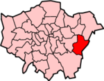
Lage in Greater LondonStatus London Borough Region Greater London Verwaltungssitz Bexleyheath Fläche 60,56 km² (289.) Einwohner (2007) 220.100 (56.) ONS-Code 00AD Website www.bexley.gov.uk London Borough of Bexley [ˈbɛksli] ist ein Stadtbezirk von London und liegt im Osten der Stadt. Bei der Gründung von Greater London im Jahr 1965 wurde er aus folgenden Gemeinden der Grafschaft Kent gebildet: Bexley, Crayford, Erith sowie etwa die Hälfte von Chislehurst and Sidcup.
Partnerstädte sind Arnsberg und Évry. Die Bevölkerung setzt sich aus 91,4 % Weißen, 3,4 % Südasiaten und 2,9 % Schwarzen zusammen.
Stadtteile
- Albany Park
- Barnehurst
- Barnes Cray
- Belvedere
- Bexley
- Bexleyheath
- Blackfen
- Blendon
- Bostall
- Bridgen
- Coldblow
- Crayford
- Crook Log
- East Wickham
- Erith
- Falconwood
- Foots Cray
- Lamorbey
- Lessness Heath
- Longlands
- May Place
- North Cray
- North End
- Northumberland Heath
- Old Bexley
- Sidcup
- Slade Green
- Thamesmead
- Upper Belvedere
- Upton
- Welling
- West Heath
Persönlichkeiten
- Kate Bush - Sängerin
- Boy George - Sänger
- Robert Knox - Nachwuchsschauspieler
Weblinks
- Bexley Borough Council (Bezirksverwaltung)
Stadtbezirke von LondonBarking and Dagenham | Barnet | Bexley | Brent | Bromley | Camden | City of London | City of Westminster | Croydon | Ealing | Enfield | Greenwich | Hackney | Hammersmith and Fulham | Haringey | Harrow | Havering | Hillingdon | Hounslow | Islington | Kensington and Chelsea | Kingston | Lambeth | Lewisham | Merton | Newham | Redbridge | Richmond | Southwark | Sutton | Tower Hamlets | Waltham Forest | Wandsworth
Sonstige Einteilung: Greater London | Inner London | Outer London | County of London

Wikimedia Foundation.