- Erie County (New York)
-
 Erie County Courthouse
Verwaltung US-Bundesstaat: New York Verwaltungssitz: Buffalo Adresse des
Verwaltungssitzes:95 Franklin Street
Buffalo, New York 14202Gründung: 2. April 1821 Gebildet aus: Niagara County Vorwahl: 001 716 Demographie Einwohner: 950.265 (2000) Bevölkerungsdichte: 351,3 Einwohner/km² Geographie Fläche gesamt: 3.178 km² Wasserfläche: 473 km² Karte 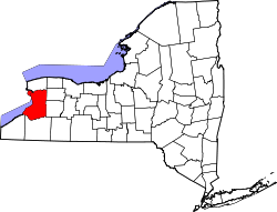
Website: www.erie.gov Erie County[1] ist ein County im Bundesstaat New York der Vereinigten Staaten von Amerika. Bei der Volkszählung im Jahr 2000 hatte das County 950.265 Einwohner und eine Bevölkerungsdichte von 351 Einwohnern pro Quadratkilometer. Der Verwaltungssitz (County Seat) ist Buffalo.
Inhaltsverzeichnis
Geschichte
Das County wurde am 2. April 1821 gebildet und nach den Erie-Indianern benannt.
Geografie
Das County hat eine Fläche von 3.178 Quadratkilometern, wovon 473 Quadratkilometer Wasserfläche sind. Erie County grenzt im Westen an den Eriesee.
Städte und Ortschaften
- Concord
- Depew
- East Aurora
- Eden
- Elma Center
- Elma
- Evans
- Farnham
- Grand Island
- Hamburg
- Harris Hill
- Holland
- Kenmore
- Lackawanna
- Lake Erie Beach
- Lancaster
- Marilla
- Newstead
- North Boston
- North Collins
- Orchard Park
- Sardinia
- Sloan
- Springville
- Tonawanda
- Town Line
- Wales
- West Seneca
- Williamsville
- Cattaraugus Reservation
- Tonawanda Reservation
Einzelnachweise
- ↑ GNIS-ID: 974113. Abgerufen am 22. Februar 2011 (englisch).
Weblinks
-
 Commons: Erie County, New York – Sammlung von Bildern, Videos und Audiodateien

Liste der Countys in New York
Albany | Allegany | Bronx | Broome | Cattaraugus | Cayuga | Chautauqua | Chemung | Chenango | Clinton | Columbia | Cortland | Delaware | Dutchess | Erie | Essex | Franklin | Fulton | Genesee | Greene | Hamilton | Herkimer | Jefferson | Kings (Brooklyn) | Lewis | Livingston | Madison | Monroe | Montgomery | Nassau | New York (Manhattan) | Niagara | Oneida | Onondaga | Ontario | Orange | Orleans | Oswego | Otsego | Putnam | Queens | Rensselaer | Richmond (Staten Island) | Rockland | Saratoga | Schenectady | Schoharie | Schuyler | Seneca | St. Lawrence | Steuben | Suffolk | Sullivan | Tioga | Tompkins | Ulster | Warren | Washington | Wayne | Westchester | Wyoming | Yates
Wikimedia Foundation.
Schlagen Sie auch in anderen Wörterbüchern nach:
County Route 574 (Erie County, New York) — County Route 574 Jamison Road Map of the Buffalo area with CR 574 … Wikipedia
County Route 560 (Erie County, New York) — Infobox NY County Route county=Erie route=560 road name=Salt Road length mi=6.67 length round=2 length ref=cite web|publisher=Erie County, New York|url=http://www.erie.gov/assessment.pdf|title=Erie County Highway Assessment|year=… … Wikipedia
Erie County, New York — Infobox U.S. County county = Erie County state = New York map size = 250 founded = 1821 seat = Buffalo | area total sq mi =1227 area land sq mi =1044 area water sq mi =183 area percentage = 14.89% census yr = 2000 pop = 950265 density km2 =351… … Wikipedia
List of county routes in Erie County, New York (545–580) — County routes in Erie County, New York (545–580) CR 546 • CR 547 • CR 548 • CR 550 • CR 551 • CR 552 • CR 553 • CR 554 • CR 555 • CR 557 •… … Wikipedia
List of county routes in Erie County, New York (513–544) — County routes in Erie County, New York (513–544) CR 519 • CR 521 • CR 523 • CR 524 • CR 526 • CR 527 • CR 528 • CR 529 • CR 530 • CR 531 •… … Wikipedia
List of county routes in Erie County, New York (385–416) — County routes in Erie County, New York (385–416) CR 385 • CR 387 • CR 388 • CR 389 • CR 390 • CR 392 • CR 393 • CR 394 • CR 395 • CR 396 •… … Wikipedia
List of county routes in Erie County, New York (65–96) — County routes in Erie County, New York (65–96) CR 65 • CR 67 • CR 68 • CR 73 • CR 74 • CR 75 • CR 82 • CR 84 • CR 85 • CR 87 • CR 90 •… … Wikipedia
List of county routes in Erie County, New York (161–192) — County routes in Erie County, New York (161–192) CR 161 • CR 162 • CR 163 • CR 164 • CR 165 • CR 166 • CR 167 • CR 169 • CR 170 • CR 171 •… … Wikipedia
List of county routes in Erie County, New York (129–160) — County routes in Erie County, New York (129–160) CR 129 • CR 130 • CR 133 • CR 134 • CR 136 • CR 137 • CR 139 • CR 140 • CR 141 • CR 142 •… … Wikipedia
List of county routes in Erie County, New York (289–320) — County routes in Erie County, New York (289–320) CR 289 • CR 290 • CR 294 • CR 295 • CR 297 • CR 299 • CR 301 • CR 303 • CR 306 • CR 307 •… … Wikipedia
Erie County (New York)


18+
© Academic, 2000-2024
- Kontaktieren Sie uns: Unterstützung, Werbung
Wörterbücher Export, schritte mit PHP, Joomla, Drupal, WordPress, MODx.